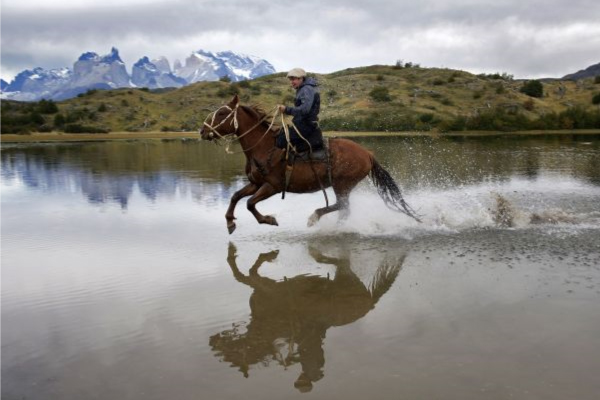
Torres del Paine
Patagonia, Chile
Explorations in
Torres del Paine
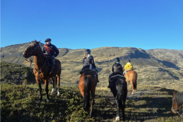
Activity
Difficulty
Areas
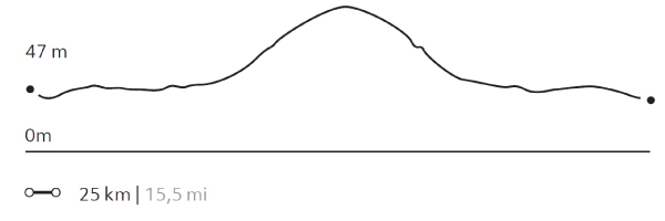
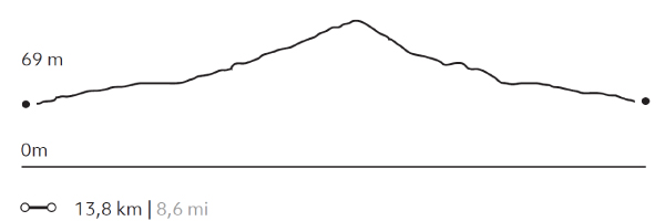
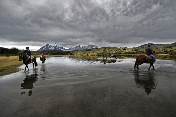
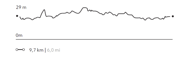
Laguna Linda
Encuentro
-
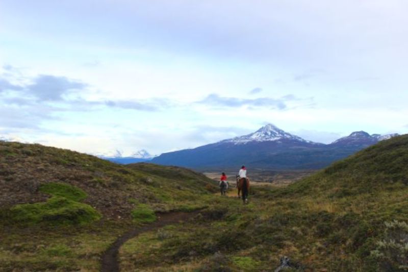
 Horseback Ride
 -
Easy
-
Half-day
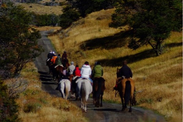
We leave from the stables and ride through an area of small hills, gaining altitude to reach the Linda Lagoon with views of the Paine massif...
More details >Laguna Linda


-
Exploration Path
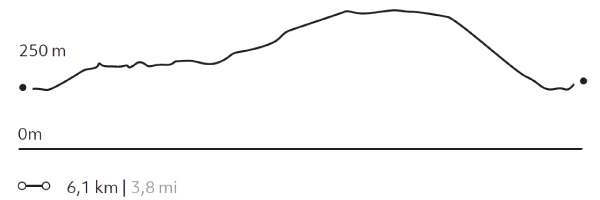
We leave from the stables and ride through an area of small hills, gaining altitude to reach the Linda Lagoon with views of the Paine massif. During this ride, we make different ascents and descents, during which we can Nothofagus forests and birds such as Fochas and Queltehues.
AONIKENK
Estepa
-
Hike
-
Moderate
-
Half-day
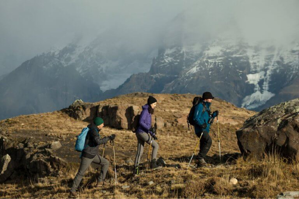
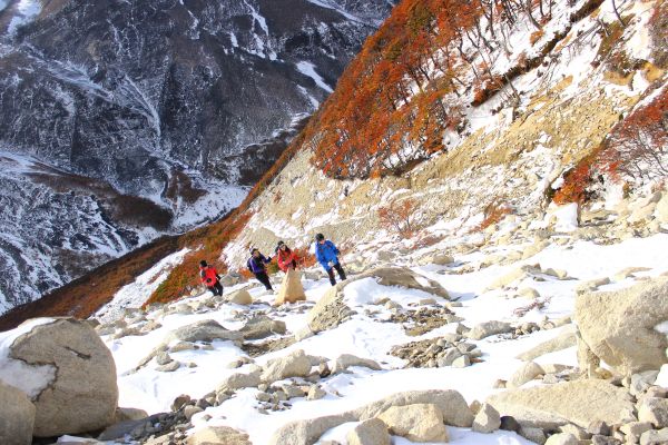
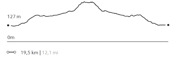
We travel by van to the eastern sector of the park, where we hike, exploring the wildlife. During the walk, we visit a cave...
More details >AONIKENK


-
Exploration Path
We travel by van to the eastern sector of the park, where we hike, exploring the wildlife. During the walk, we visit a cave with paintings that are over 4,000 years old. We can observe the geese, ducks and swans in the lagoons that are on the way. The terrain has various ascents and descents without steep slopes. Return by van.
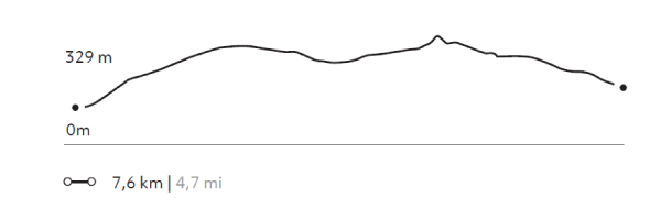
303 m 994 ft
-237 m -778 ft
329 m 1079 ft
95 m 312 ftElevation Profile
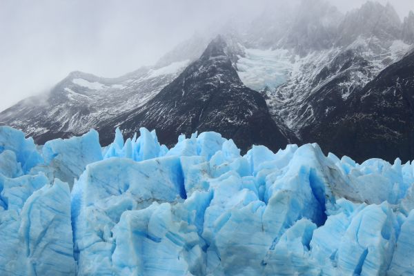
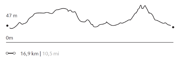
CAMPAMENTO BRITANICO
Glaciar
-
Hike
-
Expert
-
Full-day
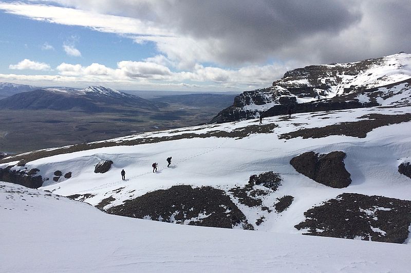
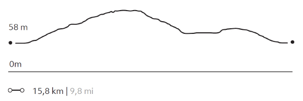
This exploration is one of the stretches of the W. We cross Pehoé Lake by catamaran to the Paine Grande refuge where we start our trek...
More details >CAMPAMENTO BRITANICO

-
Exploration Path
This exploration is one of the stretches of the W. We cross Pehoé Lake by catamaran to the Paine Grande refuge where we start our trek to the heart of the Francés Valley. We arrive at the Britanico viewpoint while trekking through lenga forests, approaching the Paine Horns.
872 m 2861 ft
-872 m -2861 ft
712 m 2.336 ft
39 m 128 ftElevation Profile
GUARDAS
Glaciar
-
Hike
-
Expert
-
Full-day
We cross Pehoé Lake on a catamaran to the Paine Grande refuge where we begin our trek to the Grey refuge...
More details >GUARDAS
-
Exploration Path
We cross Pehoé Lake on a catamaran to the Paine Grande refuge where we begin our trek to the Grey refuge. From there, we walk towards the viewpoint at Guardas camp with panoramic views of the glacier. We return to the refuge. There we board a boat that will take us to the glacier and then leave us on the other side of Grey Lake. We walk back to the van.
*Browsing is subject to the availability of Explora's external operator.
857 m 2812 ft
-849 m -2785 ft
306 m 1.004 ft
39 m 128 ftElevation Profile
BASE TORRES
Montañas
-
High Mountain Ascent
-
Expert
-
Full-day
This exploration goes through one of the most iconic sectors of the W. We travel by van to the Cerro Paine ranch where we begin...
More details >BASE TORRES

-
Exploration Path
This exploration goes through one of the most iconic sectors of the W. We travel by van to the Cerro Paine ranch where we begin our ascent to the base of the Torres del Paine. At the top, we can appreciate the magnitude of the granite towers and the lagoon at our feet. We return by the same road.
1153 m 3783 ft
-1153 m -3783 ft
885 m 2.904 ft
123 m 404 ftElevation Profile
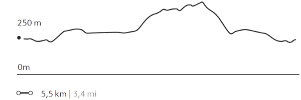
Cerro Castillo
Montañas
-
High Mountain Ascent
-
Expert
-
Full-day
We travel by van to El Bote Bay, a sector located outside the park. We start our walk in a cattle area and go up the slope of Castillo Hill...
More details >Cerro Castillo
-
Exploration Path
We travel by van to El Bote Bay, a sector located outside the park. We start our walk in a cattle area and go up the slope of Castillo Hill until we reach the summit. From there, we have a 360 ° view of the park and its surroundings. We see hills, glaciers, pampas, lakes and mountains. We descend through a forested area to the van.
1170 m 3839 ft
-1170 m -3839 ft
983 m 3.225 ft
57 m 187 ftElevation Profile
CERRO TENERIFE
Montañas
-
High Mountain Ascent
-
Expert
-
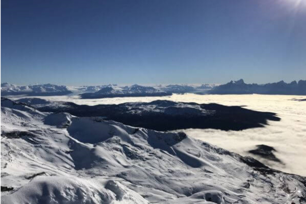
Full-day
We travel by van to the base of the Tenerife Hill. We begin our ascent through a forest of ñirres, lengas and coigües, continue among...
More details >CERRO TENERIFE
-
Exploration Path
We travel by van to the base of the Tenerife Hill. We begin our ascent through a forest of ñirres, lengas and coigües, continue among humid scrub vegetation and finally through a high desert area. This is a remarkable exploration for the panoramic views it offers: to the Southern Ice Fields and the Chacabuco mountain range, among others.
1582 m 5190 ft
-1582 m -5190 ft
1.564 m 5.131 ft
67 m 220 ftElevation Profile
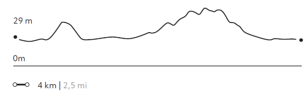
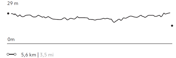
LAGUNA NEGRA
Encuentro
-
Horseback Ride
-
Easy
-
Half-day
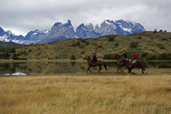
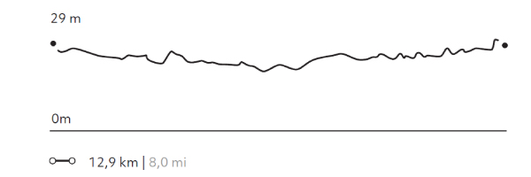
We depart from the stables and ride across rivers, forests and pampas as we ascend towards the viewpoint of the Negra Lagoon...
More details >LAGUNA NEGRA
-
Exploration Path
We depart from the stables and ride across rivers, forests and pampas as we ascend towards the viewpoint of the Negra Lagoon. On the way we pass by several lagoons, ideal for spotting different species of birds such as Queltehues or Magellanic geese.
54 m 177 ft
-54 m -177 ft
53 m 174 ft
28 m 92 ftElevation Profile
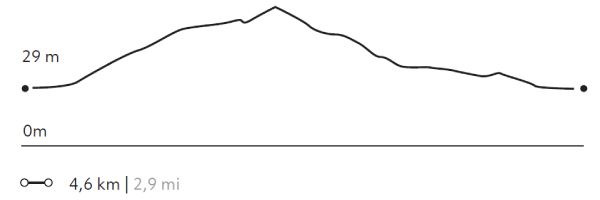
PUNTILLA DEL TORO
Estepa
-
Horseback Ride
-
Easy
-
Half-day
We depart from the stables riding through the Pampa Serrano, crossing streams and rivers with the Paine massif behind us...
More details >PUNTILLA DEL TORO
-
Exploration Path
We depart from the stables riding through the Pampa Serrano, crossing streams and rivers with the Paine massif behind us. We ride along the banks of the Serrano River and the Toro Lake, which we cross at different points. We return by way of the Pampa with clear views to the massif.
14 m 46 ft
-14 m -46 ft
30 m 98 ft
26 m 85 ftElevation Profile
BUENA VISTA
Encuentro
-
Horseback Ride
-
Easy
-
Half-day
We leave from the stables towards a plain with abundant flora and fauna. Then we ascend a hill...
More details >BUENA VISTA
-
Exploration Path
We leave from the stables towards a plain with abundant flora and fauna. Then we ascend a hill, gaining altitude until we reach the Buena Vista viewpoint, from where we see the mouth of the Paine River and the massif in the background. We return to the stables by a steep path.
181 m 594 ft
-181 m -594 ft
176 m 577 ft
28 m 92 ftElevation Profile
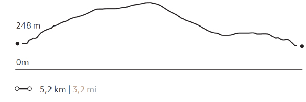
CAÑADÓN MACHO
Bosque

-
Horseback Ride
-
Easy
-
Half-day
We ride from our quincho to an extensive forest of beech trees. Leaving the forest, we have panoramic views of the Las Chinas River...
More details >CAÑADÓN MACHO
-
Exploration Path
We ride from our quincho to an extensive forest of beech trees. Leaving the forest, we have panoramic views of the Las Chinas River and the waterfall located in the river gorge. We continue riding on a more open road until we arrive back at the quincho.
194 m 636 ft
-194 m -636 ft
408 m 1.339 ft
251 m 823 ftElevation Profile
PUENTE GREY
Estepa
-
Horseback Ride
-
Advanced
-
Half-day
We start riding from the explora stables towards the Grey River on mostly flat and open terrains. We arrive at the river bank...
More details >PUENTE GREY

-
Exploration Path
We start riding from the Explora stables towards the Grey River on mostly flat and open terrains. We arrive at the river bank and continue riding along its channel. Finally, we return to the stables along the same road.
*For experienced and advanced riders only. This exploration is only available for advanced riders who have mastered rising trot and canter over uneven terrain in open spaces and on all types of horses. Advanced riders are physically fit and able to canter for long stretches without getting tired.
35 m 115 ft
-35 m -115 ft
35 m 115 ft
26 m 85 ftElevation Profile
MERCADO
Estancia
-
Horseback Ride
-
Advanced
-
Half-day
We set off from the quincho and cross the Las Chinas River on horseback, riding towards the Mercado estancia valley...
More details >MERCADO
-
Exploration Path
We set off from the quincho and cross the Las Chinas River on horseback, riding towards the Mercado estancia valley. On the way, we can gallop and trot through extensions of Patagonian steppe. On our way back to the quincho, we cross the river again.
* Not recommended for travelers with fear of heights.
**For experienced and advanced riders only. This exploration is only available for advanced riders who have mastered rising trot and canter over uneven terrain in open spaces and on all types of horses. Advanced riders are physically fit and able to canter for long stretches without getting tired.
294 m 965 ft
-294 m -965 ft
414 m 1.358 ft
234 m 768 ftElevation Profile
SANTA GEMITA
Estancia
-
Horseback Ride
-
Advanced
-
Half-day
We ride from the quincho to the Las Chinas River, which we cross to begin a climb towards the foot of the Jara mountain range...
More details >SANTA GEMITA
-
Exploration Path
We ride from the quincho to the Las Chinas River, which we cross to begin a climb towards the foot of the Jara mountain range. We go along the mountain range until we reach Santa Gemita, where we have views of the Azul Lagoon and the Torres del Paine. Finally, we descend to return.
* Not recommended for travelers with fear of heights.
** For experienced and advanced riders only. This exploration is only available for advanced riders who have mastered rising trot and canter over uneven terrain in open spaces and on all types of horses. Advanced riders are physically fit and able to canter for long stretches without getting tired.
228 m 748 ft
-228 m -748 ft
385 m 1.263 ft
233 m 764 ftElevation Profile
SERRANO
Estepa
-
Horseback Ride
-
Advanced
-
Half-day
We depart from the stables riding on a plain along the Serrano River. Then, we cross some paths to a viewpoint...
More details >SERRANO
-
Exploration Path
We depart from the stables riding on a plain along the Serrano River. Then, we cross some paths to a viewpoint from where we see a village on the outskirts of the park and the immensity of the plain that surrounds us. On the way back, we cross a small forest.
* For experienced and advanced riders only. This exploration is only available for advanced riders who have mastered rising trot and canter over uneven terrain in open spaces and on all types of horses. Advanced riders are physically fit and able to canter for long stretches without getting tired.
31 m 102 ft
-31 m -102 ft
30 m 98 ft
28 m 92 ftElevation Profile
-
Other options: