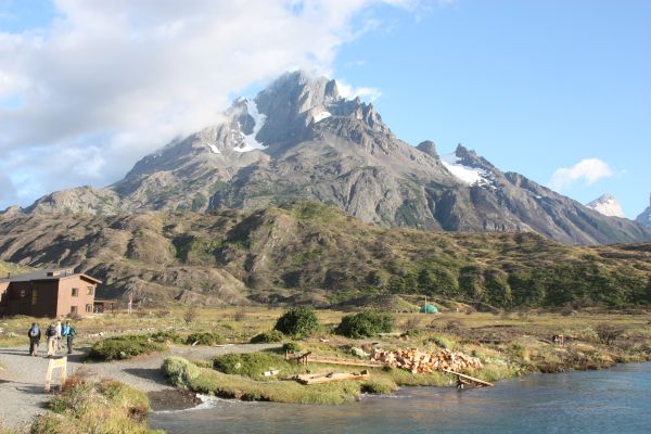
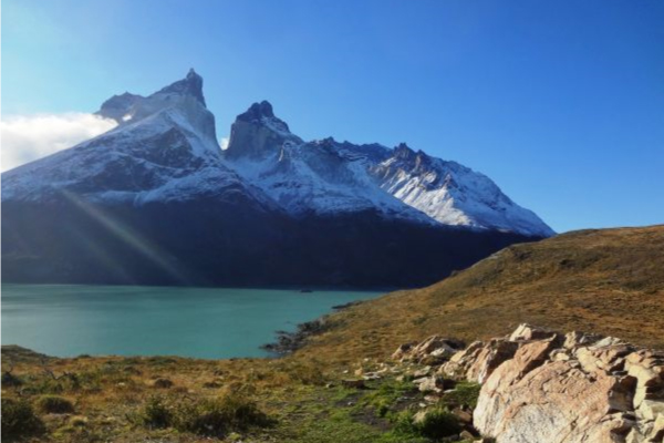
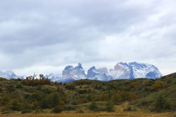
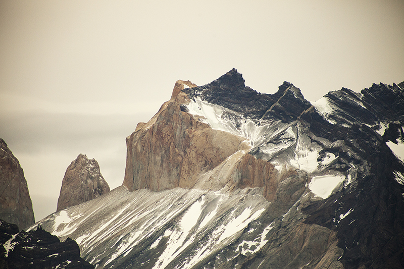
Torres del Paine
Patagonia, Chile
Explorations in
Torres del Paine
Activity
Difficulty
Areas
DONOSITO
Encuentro
-
 Horseback Ride
 -
Advanced
-
Half-day
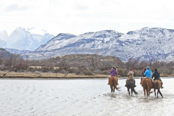
We depart from the stables riding through the Serrano pampas, cross the Grey bridge and ride along the river bank...
More details >DONOSITO


-
Exploration Path
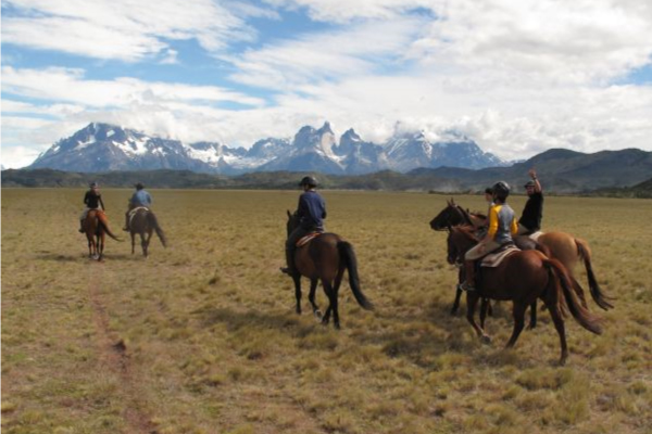
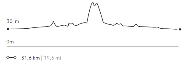
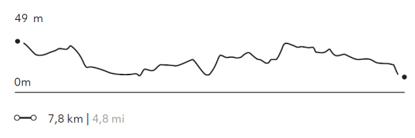
We depart from the stables riding through the Serrano pampas, cross the Grey bridge and ride along the river bank. From there, we ascend a hill with dense vegetation. We pass through wetlands until we reach the Donosito viewpoint with views of the Serrano and Grey rivers, the plain and the Paine massif.
* For experienced and advanced riders only. This exploration is only available for advanced riders who have mastered rising trot and canter over uneven terrain in open spaces and on all types of horses. Advanced riders are physically fit and able to canter for long stretches without getting tired.
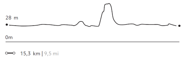
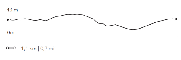
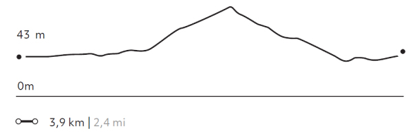
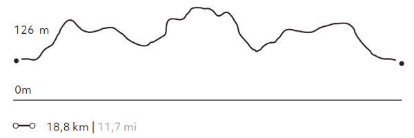
143 m 469 ft
-143 m -469 ft
101 m 331 ft
28 m 92 ftElevation Profile
DONOSO
Encuentro
-
Horseback Ride
-
Advanced
-
Full-day
We depart from the stables riding through the Pampa Serrano. We cross the Grey River and climb a hill crossing streams...
More details >DONOSO
-
Exploration Path
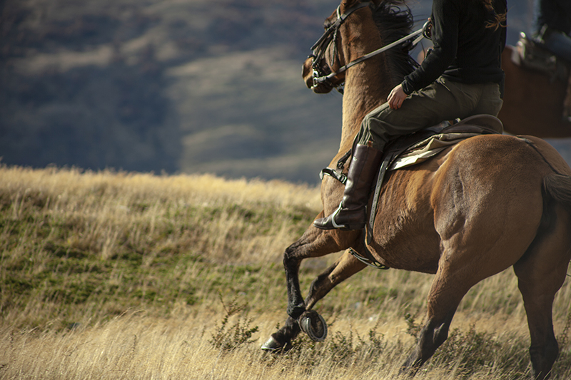
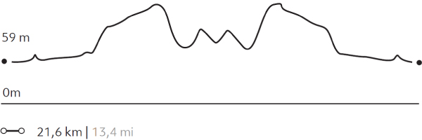
We depart from the stables riding through the Pampa Serrano. We cross the Grey River and climb a hill crossing streams, lagoons, plains and wetlands to the Donosito overlook with views of rivers, the Pampas and the Paine massif. We ascend up a narrow and pronounced path between trees to the Choros Lagoon. After lunch in the forest, we return to the stables.
* For experienced and advanced riders only. This exploration is only available for advanced riders who have mastered rising trot and canter over uneven terrain in open spaces and on all types of horses. Advanced riders are physically fit and able to canter for long stretches without getting tired.
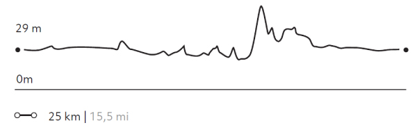
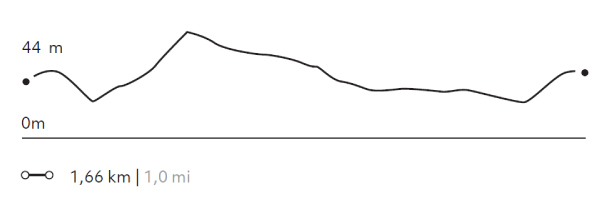
260 m 853 ft
-260 m -853 ft
87 m 285 ft
14 m 46 ftElevation Profile
TÉMPANOS
Encuentro
-
Horseback Ride
-
Expert
-
Full-day
We depart from the stables, galloping through plains and rocky terrain until we reach the banks of the Grey River...
More details >TÉMPANOS

-
Exploration Path
We depart from the stables, galloping through plains and rocky terrain until we reach the banks of the Grey River. We continue towards a hill, up a steep slope to the Témpanos viewpoint, from where we can see Grey Lake, its ice fields and the glacier in the distance.
* For experienced and advanced riders only. This exploration is only available for advanced riders who have mastered rising trot and canter over uneven terrain in open spaces and on all types of horses. Advanced riders are physically fit and able to canter for long stretches without getting tired.
505 m 1657 ft
-505 m -1657 ft
217 m 712 ft
28 m 92 ftElevation Profile
2 DE ENERO
Estancia
-
Horseback Ride
-
Expert
-
Half-day
We depart from the quincho in the direction of the bank of the Seca Lagoon, along a steep slope...
More details >2 DE ENERO
-
Exploration Path
We depart from the quincho in the direction of the bank of the Seca Lagoon, along a steep slope. Then, we arrive at a viewpoint from where we see the 2 de Enero Estancia, where the gauchos will receive us to drink hot mate. We return through irregular terrain and forests to the quincho.
* For experienced and advanced riders only. This exploration is only available for advanced riders who have mastered rising trot and canter over uneven terrain in open spaces and on all types of horses. Advanced riders are physically fit and able to canter for long stretches without getting tired.
375 m 1230 ft
-375 m -1230 ft
475 m 1.558 ft
235 m 771 ftElevation Profile
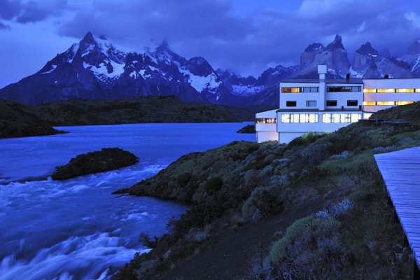
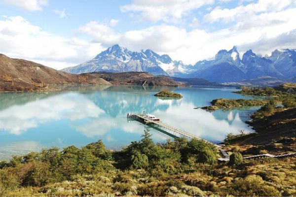
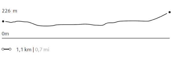
SALTO CHICO
Encuentro
-
Self Guided
-
Easy
-
Half-day
This walk of the catwalks of the hotel is an invitation to contemplate the landscapes that surround us...
More details >SALTO CHICO


-
Exploration Path
This walk of the catwalks of the hotel is an invitation to contemplate the landscapes that surround us. We suggest walking towards the pier with views of the Paine massif, continuing towards the arrival road to the hotel and then connecting with the footbridges towards the Paine River, where the spa is. Continue towards the viewpoint of the Salto Chico waterfall and from there to the entrance.
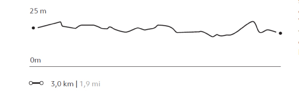
27 m 87 ft
-26 m -84 ft
49 m 161 ft
32 m 105 ftElevation Profile
RIBERA PAINE
Encuentro
-
Self Guided
-
Easy
-
Half-day
Exit through the main door and walk to the spa by the walkway. Continue on a dirt road to a path...
More details >RIBERA PAINE
-
Exploration Path
Exit through the main door and walk to the spa by the walkway. Continue on a dirt road to a path by which you will ascend a couple of minutes and turn right following stakes with orange marks between small hills. Descend to the Paine River and continue along the riverbank to the spa. Return by the catwalk.
58 m 192 ft
-58 m -191 ft
65 m 213 ft
29 m 95 ftElevation Profile
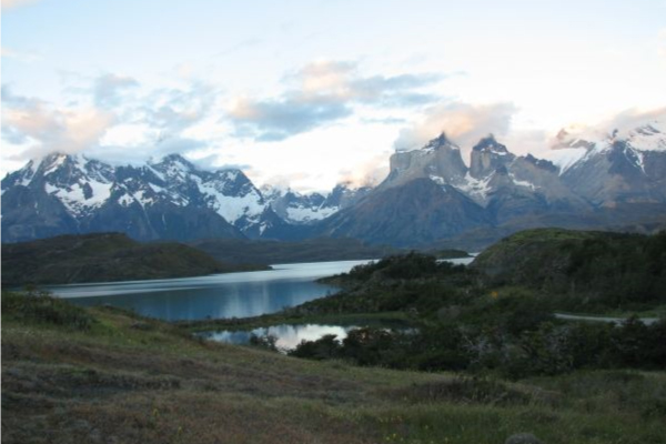
LAGO PEHOÉ
Encuentro
-
Self Guided
-
Easy
-
Half-day
This walk amongst orchids and ñirres offers incredible views of Pehoé Lake, the Paine mountain range...
More details >LAGO PEHOÉ
-
Exploration Path
This walk amongst orchids and ñirres offers incredible views of Pehoé Lake, the Paine mountain range and the Paine River in the distance. Exit the main road following the shore of Pehoé Lake and ascend to the triangular rock marked on the map.
182 m 597 ft
-181 m -594 ft
176 m 577 ft
28 m 92 ftElevation Profile
PAMPA
Estepa
-
Overland
-
Easy
-
Half-day
We will visit the south-west area of the park, making various stops and short walks that will allow us to discover important landmarks...
More details >PAMPA

-
Exploration Path
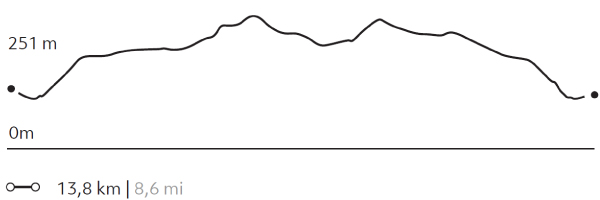
We will visit the south-west area of the park, making various stops and short walks that will allow us to discover important landmarks in the history of Patagonia and the national park. We will cross various ecosystems associated with higher humidity, such as the banks of the Serrano River or the Lenga and Ñirre forests. We will have the opportunity to see various types of waterfowl, while we make stops to observe the lake and Gray Glacier, share a tea and enjoy one of the best views of the Paine massif.
ESTEPA PATAGÓNICA
Estepa

-
Overland
-
Easy
-
Half-day
We travel through the eastern sector of the park combining stretches in van with short walks...
More details >ESTEPA PATAGÓNICA
-
Exploration Path
We travel through the eastern sector of the park combining stretches in van with short walks. This sector is mainly characterized by the presence of animals such as guanacos, pumas and diversity of birds, as well as its extensive pampas, typical of the Patagonian steppe. First we visit the Nordenskjöld Lake viewpoint and the Paine Grande waterfall, then we travel by van to the Los Cisnes Lagoon and finally to the Amarga Lagoon.
*Available only select months of the year according to the activity of the estancieros. Coordinated at the destination.
Aves Australes
Encuentro
-
Overland
-
Moderate
-
Full-day
Ideal for lovers of flora and fauna, this exploration takes place outside the park, in the surroundings of a lagoon...
More details >Aves Australes

-
Exploration Path
Ideal for lovers of flora and fauna, this exploration takes place outside the park, in the surroundings of a lagoon inhabited by different bird species. We hike while contemplating the varied vegetation and the behavior and sound of the birds. Between September and April, sightings increase due to the favorable conditions offered by spring and summer.
139 m 456 ft
-139 m -456 ft
49 m 161 ft
30 m 98 ftElevation Profile
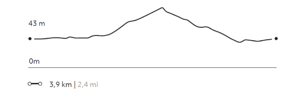
VALLE DEL RÍO PINGO
Bosque
-
Hike
-
Advanced
-
Full-day
We travel by van to the Grey Lake refuge where we start walking along the Pingo River. We cross the river to reach forests...
More details >VALLE DEL RÍO PINGO

-
Exploration Path
We travel by van to the Grey Lake refuge where we start walking along the Pingo River. We cross the river to reach forests through which the Paine Grande can be seen. We return on the same road to the refuge to get on the van and return to Explora.
745 m 2444 ft
-745 m -2444 ft
313 m 1.027 ft
57 m 187 ftElevation Profile
CUERNOS
Encuentro
-
Hike
-
Advanced
-
Full-day
We travel by van to the Cerro Paine estancia, where we begin our trek. We walk along Nordenskjöld Lake...
More details >CUERNOS
-
Exploration Path
We travel by van to the Cerro Paine estancia, where we begin our trek. We walk along Nordenskjöld Lake until we reach the uphill path of the Bader Valley with views of the horns, the Pehoé, Sarmiento and Nordenskjöld lakes and the Almirante Nieto glacier.
664 m 2178 ft
-664 m -2178 ft
269 m 883 ft
123 m 404 ftElevation Profile
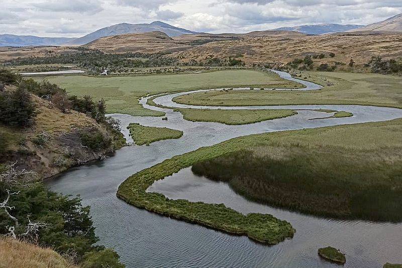
RIBERA SERRANO
Estepa
-
Hike
-
Easy
-
Half-day
We travel by van to the Serrano entrance, where we start our walk. We hike through the Pampa of the same name...
More details >RIBERA SERRANO
-
Exploration Path
We travel by van to the Serrano entrance, where we start our walk. We hike through the Pampa of the same name, guided by the channel and some birds of the Serrano River. We will appreciate the contrast of the green meadows and the granite of the Paine massif. We return to the hotel by van.
15 m 49 ft
-18 m -59 ft
28 m 92 ft
21 m 69 ftElevation Profile
LAGUNA AZUL
Bosque
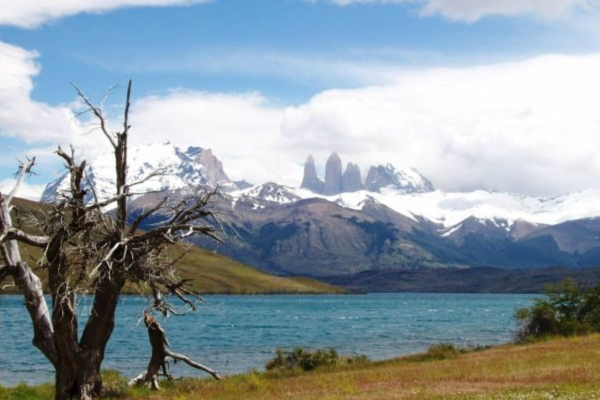
-
Hike
-
Easy
-
Half-day
We start at our quincho where we take a van to the Azul Lagoon. From there we walk around a wetland...
More details >LAGUNA AZUL
-
Exploration Path
We start at our quincho where we take a van to the Azul Lagoon. From there we walk around a wetland inhabited by multiple birds and cross the beach of the lagoon watching the Torres del Paine peek above the horizon. Finally, we arrive at a viewpoint and return by van.
22 m 72 ft
-16 m -52 ft
234 m 768 ft
223 m 732 ftElevation Profile
MIRADOR PEHOE
Encuentro
-
Hike
-
Easy
-
Half-day
We leave the hotel walking along the shore of Pehoé Lake, observing the orchids and ñirre trees that make up the local flora...
More details >MIRADOR PEHOE
-
Exploration Path
We leave the hotel walking along the shore of Pehoé Lake, observing the orchids and ñirre trees that make up the local flora. We ascend to a viewpoint from which you can see the extension of the lake and the Paine mountain range from a different perspective than you have previously from explora.
187 m 614 ft
-185 m -607 ft
181 m 594 ft
28 m 92 ftElevation Profile
-
Other options: