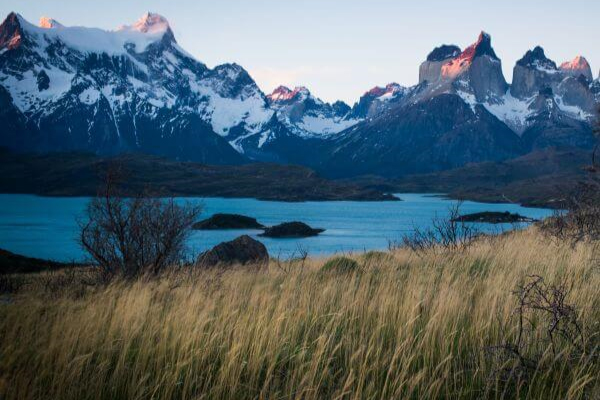
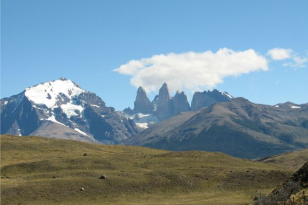
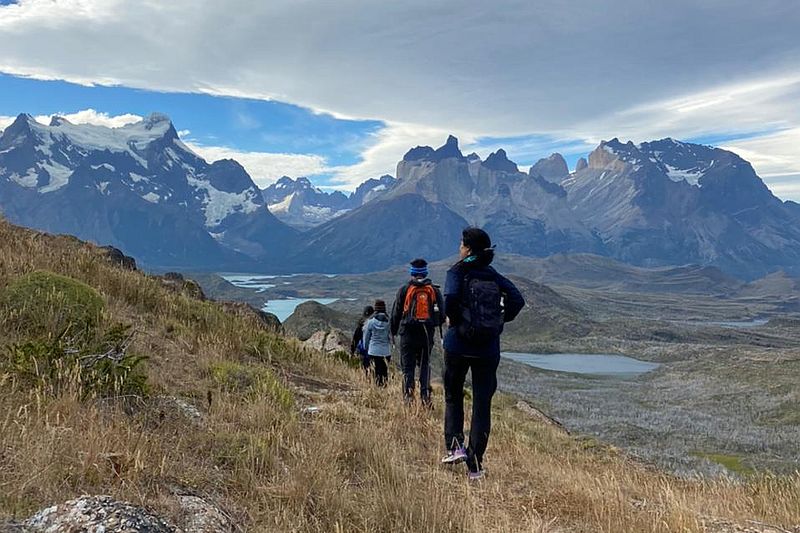
Torres del Paine
Patagonia, Chile
Explorations in
Torres del Paine
Activity
Difficulty
Areas
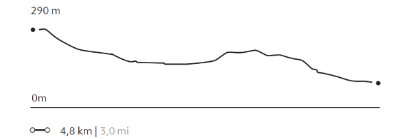
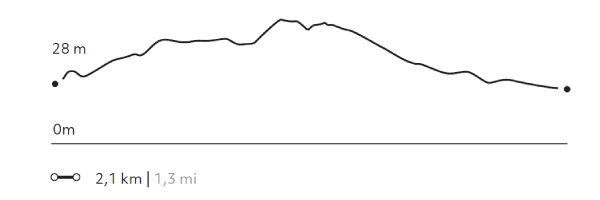
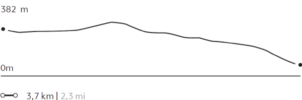
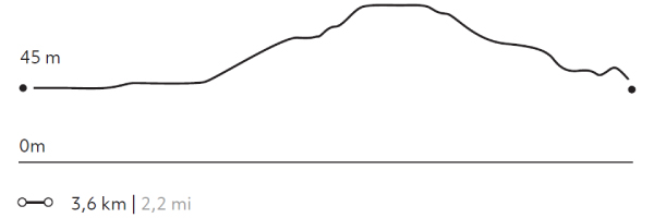
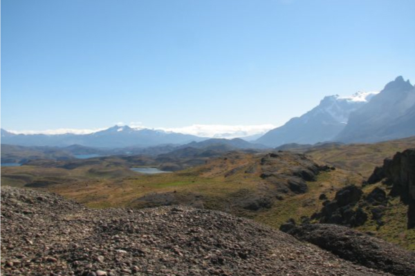
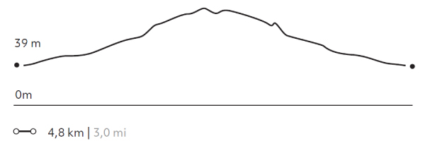
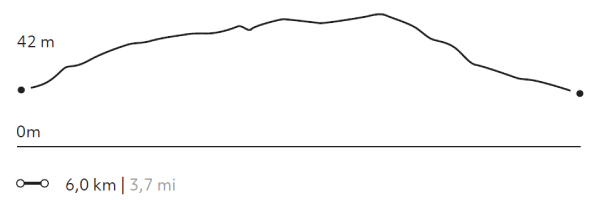
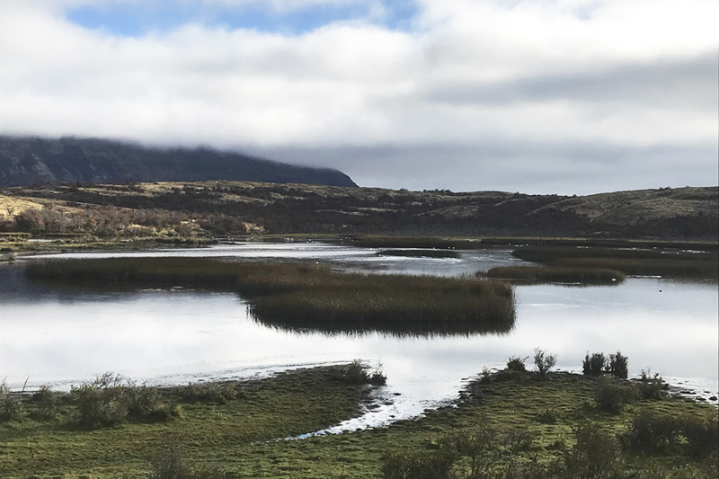
LAGUNA LARGA
Estepa
-
 Hike
Hike -
Easy
-
Half-day
We skirt the Larga Lagoon, walking among stromatolite rock formations, whose singular appearance contrasts with the colors...
More details >LAGUNA LARGA


-
Exploration Path
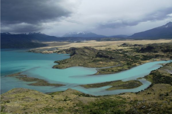
We skirt the Larga Lagoon, walking among stromatolite rock formations, whose singular appearance contrasts with the colors of the lagoon and the overall landscape. We continue walking with views of the Paine Horns to a viewpoint overlooking Nordenskjöld Lake. We return to the hotel by van.
55 m 182 ft
-212 m -696 ft
291 m 955 ft
133 m 436 ftElevation Profile
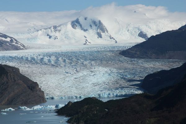
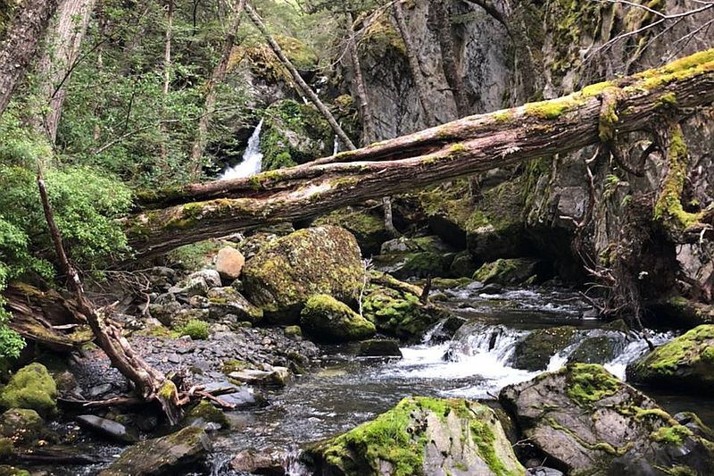
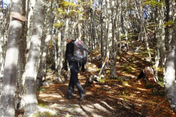
LAGO GREY
Bosque
-
Hike
-
Easy
-
Half-day
We travel by van to Grey Lake. We start our walk crossing the suspension bridge over the Pingo River and continue through a forest...
More details >LAGO GREY
-
Exploration Path
We travel by van to Grey Lake. We start our walk crossing the suspension bridge over the Pingo River and continue through a forest until we reach the lake shore. Once there we walk along the beach to see the glacier and the icebergs that come off it. We return by van.
126 m 413 ft
-126 m -413 ft
82 m 269 ft
45 m 148 ftElevation Profile
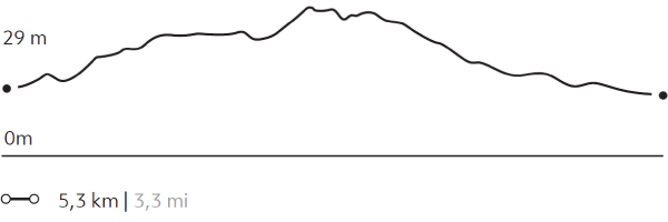
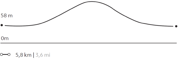
MIRADOR MASLE
Bosque
-
Hike
-
Easy
-
Half-day
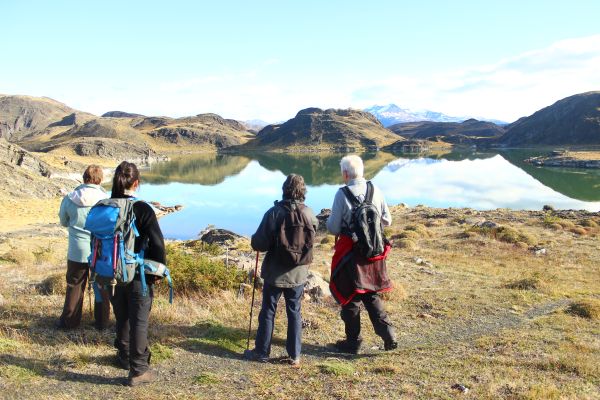
We start by hiking around the Laguna Azul where guanacos and different species of birds commonly meander. Then we ascend...
More details >MIRADOR MASLE
-
Exploration Path
We start by hiking around the Laguna Azul where guanacos and different species of birds commonly meander. Then we ascend by a path through which we arrive at an overlook with views of the Paine massif. Descending, a van waits for us to return to the lodge.
164 m 538 ft
-164 m -538 ft
375 m 1.230 ft
233 m 764 ftElevation Profile
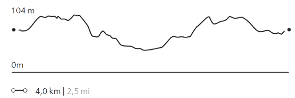
NORDENSKJÖLD
Encuentro
-
Hike
-
Easy
-
Half-day
We travel by van to Salto Grande and begin our trek with views of the Paine Grande and its hanging glaciers. Then, we reach the turquoise...
More details >NORDENSKJÖLD
-
Exploration Path
We travel by van to Salto Grande and begin our trek with views of the Paine Grande and its hanging glaciers. Then, we reach the turquoise waters of Lake Nordenskjöld, at the foot of the massif where the sound of breaking ice can occasionally be heard. We return to the lodge by van.
133 m 436 ft
-139 m -456 ft
116 m 381 ft
62 m 203 ftElevation Profile
MIRADOR TORO
Encuentro
-
Hike
-
Easy
-
Half-day
We travel by van to the Weber bridge, from which we walk to Toro Lake. On the way we can observe evidence...
More details >MIRADOR TORO
-
Exploration Path
We travel by van to the Weber bridge, from which we walk to Toro Lake. On the way we can observe evidence of the ice that once covered the park. We ascend to an overlook with panoramic views. On the descent we pass by a lagoon. We return by van.
98 m 322 ft
-98 m -322 ft
83 m 272 ft
25 m 82 ftElevation Profile
SARMIENTO
Estepa
-
Hike
-
Moderate
-
Half-day
We begin walking along a path between low-lying vegetation and colorful native flowers. Then, we descend to the beach of Sarmiento Chico Lake...
More details >SARMIENTO

-
Exploration Path
We begin walking along a path between low-lying vegetation and colorful native flowers. Then, we descend to the beach of Sarmiento Chico Lake, crossing rock formations of calcium carbonate. Finally, we ascend to panoramic views of Sarmiento Lake. We return by van.
100 m 328 ft
-100 m -328 ft
125 m 410 ft
80 m 262 ftElevation Profile
LA LOMA
Bosque
-
Hike
-
Moderate
-
Half-day
From a steppe area, we walk to a small hill overlooking the Torres del Paine. Then we cross native forests, observing the rich wild life...
More details >LA LOMA
-
Exploration Path
From a steppe area, we walk to a small hill overlooking the Torres del Paine. Then we cross native forests, observing the rich wild life of the park. At the end of our excursion, we make a descent through open terrain, allowing us to feel the Patagonian wind. We return to lodge by van.
58 m 190 ft
-234 m -768 ft
430 m 1.411 ft
205 m 673 ftElevation Profile
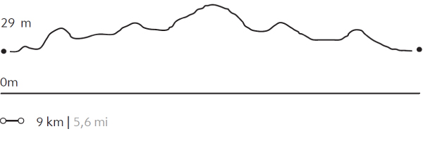
Pingo Chorrillo
Bosque
-
Hike
-
Moderate
-
Half-day
We travel by van to Grey Lake. From there, we walk along a path along the Pingo River through a forest of native trees...
More details >Pingo Chorrillo
-
Exploration Path
We travel by van to Grey Lake. From there, we walk along a path along the Pingo River through a forest of native trees. During this exploration, we can enjoy different views of the Paine massif and bird watching. The return is by the same path.
235 m 771 ft
-235 m -771 ft
105 m 344 ft
56 m 184 ftElevation Profile
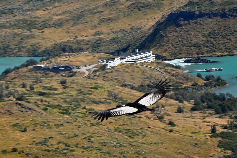
Mirador Condor
Encuentro
-
Hike
-
Moderate
-
Half-day
We leave the hotel, walking along the shore of Pehoé Lake. In the distance, we see a hill on the summit...
More details >Mirador Condor
-
Exploration Path
We leave the hotel, walking along the shore of Pehoé Lake. In the distance, we see a hill on the summit of which is the Condor lookout, our destination. On the way, we pass through lenga and ñirre forests. When we get to the top, we have a 360° view of the park. We descend down a rocky slope to the van.
253 m 830 ft
-232 m -761 ft
239 m 784 ft
45 m 148 ftElevation Profile
MIRADOR SIERRA DEL TORO
Encuentro
-
Hike
-
Advanced
-
Half-day
We travel by van to the mouth of the Paine River, where we begin a steep and rocky ascent of the sierra, a place off the beaten track...
More details >MIRADOR SIERRA DEL TORO

-
Exploration Path
We travel by van to the mouth of the Paine River, where we begin a steep and rocky ascent of the sierra, a place off the beaten track. The vegetation is low, allowing incredible views of Toro Lake, Paine River, the Pampa Serrano and the mountains of the area. We return by van.
454 m 1490 ft
-454 m -1490 ft
432 m 1.417 ft
38 m 125 ftElevation Profile
Cornisas
Encuentro
-
Hike
-
Advanced
-
Half-day
We walk towards the Paine River until we reach the cliffs that give name to this exploration. As we gain altitude...
More details >Cornisas
-
Exploration Path
We walk towards the Paine River until we reach the cliffs that give name to this exploration. As we gain altitude, we have panoramic views from different perspectives. We see the Paine River, Pehoé Lake and at the top, we can contemplate the Paine mountain range and the surrounding valleys.
414 m 1358 ft
-427 m -1401 ft
373 m 1.224 ft
28 m 92 ftElevation Profile
FERRIER
Bosque
-
Hike
-
Expert
-
Half-day
We travel by van to the Grey Lake where we begin a demanding ascent during which we get views of the Lake...
More details >FERRIER

-
Exploration Path
We travel by van to the Grey Lake where we begin a demanding ascent during which we get views of the Lake and the huge ice mass of the South Ice Fields. We cross a forest and continue to the top with panoramic views of the Grey and Pehoé lakes. We descend and return by van.
612 m 2008 ft
-612 m -2008 ft
642 m 2.106 ft
56 m 184 ftElevation Profile
Juncales
Encuentro
-
Hike
-
Moderate
-
Full-day
We travel by van to an area rich in wildlife and birds. We begin the walk bordering a lagoon with reed islets...
More details >Juncales
-
Exploration Path
We travel by van to an area rich in wildlife and birds. We begin the walk bordering a lagoon with reed islets, where a natural habitat for different types of birds has been formed. We will continue walking with views of the Toro Lake and the hills of Castillo and Tenerife. We recommend this exploration to travelers interested in bird watching.
241 m 791 ft
-239 m -784 ft
85 m 279 ft
30 m 98 ftElevation Profile
VALLE DEL FRANCÉS
Glaciar

-
Hike
-
Moderate
-
Full-day
We cross the Pehoé Lake by catamaran to the Paine Grande refuge where we start the trek. We enter the Francés Valley...
More details >VALLE DEL FRANCÉS
-
Exploration Path
We cross the Pehoé Lake by catamaran to the Paine Grande refuge where we start the trek. We enter the Francés Valley through a forest, cross the suspension bridge over the Francés River and continue to the Italian Camp. From there, we see the glacier and the granite peaks that frame the area. We return by the same trail.
473 m 1552 ft
-473 m -1552 ft
275 m 902 ft
39 m 128 ftElevation Profile
GLACIAR GREY
Glaciar

-
Hike
-
Moderate
-
Full-day
We cross the Pehoé Lake by catamaran to the Paine Grande refuge to cross one of the stretches of the W. Around the midpoint...
More details >GLACIAR GREY
-
Exploration Path
We cross the Pehoé Lake by catamaran to the Paine Grande refuge to cross one of the stretches of the W. Around the midpoint of the hike, we can see the Grey Glacier and the Southern Ice Fields. We continue walking to the beach of Grey Lake where we board a boat that brings us to the glacier and then leaves us on the other side of the lake. We walk along the beach and through a forest to the van.
*Browsing is subject to the availability of Explora's external operator.
538 m 1765 ft
-516 m -1693 ft
273 m 896 ft
29 m 95 ftElevation Profile
-
Other options: