Sacred Valley
Machu Picchu & Sacred Valley, Peru
Explorations in
Sacred Valley
Activity
Difficulty
Areas
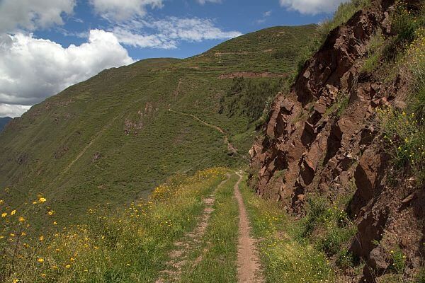
Moray Avalanche
Quechua
-
 Combination
 -
Moderate
-
Full-day
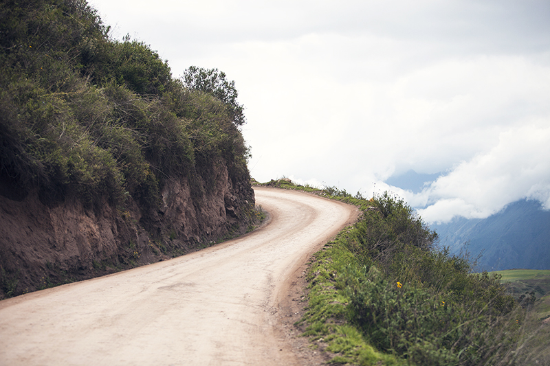
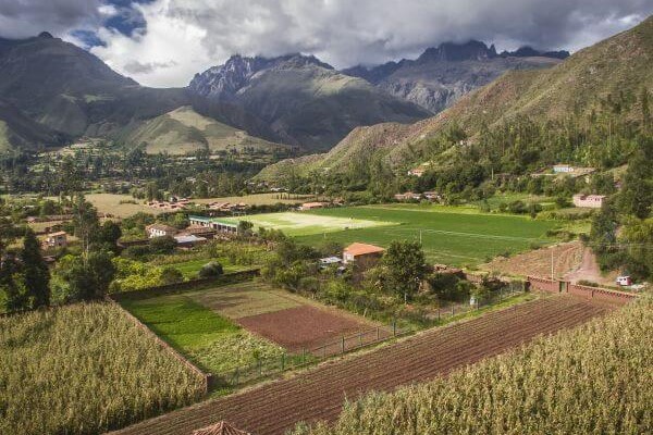
Our exploration begins with a hike through a community located in the hills, and descends to the Inca ruins of Moray, a special site...
More details >Moray Avalanche


-
Exploration Path
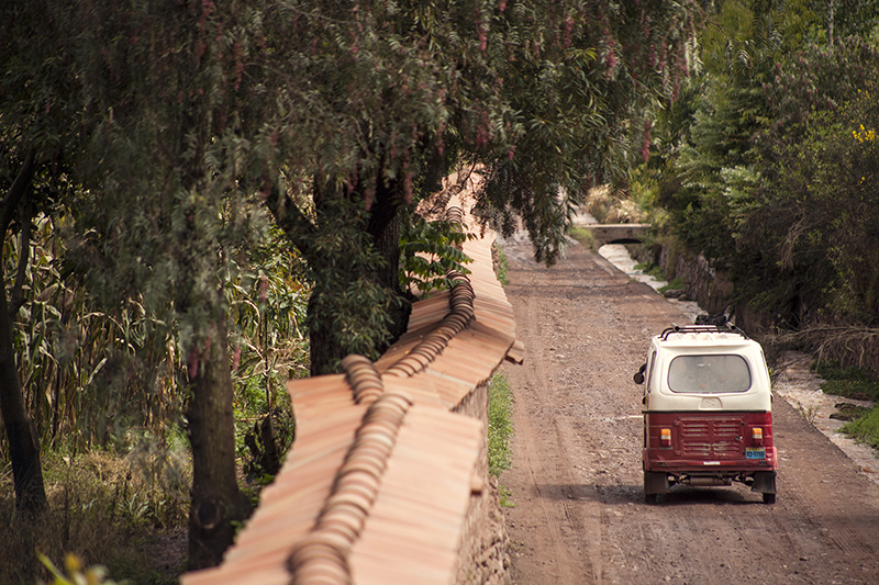
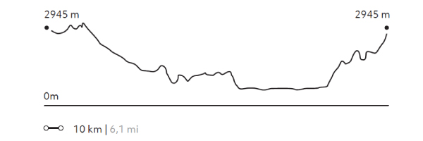
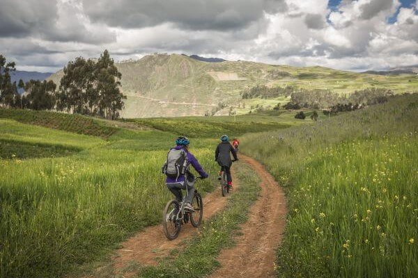
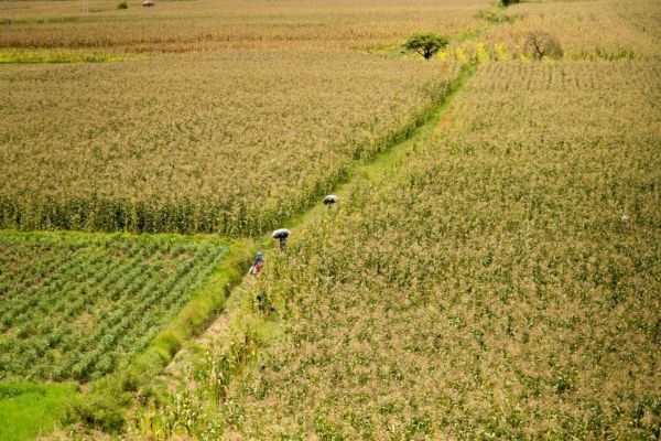
Our exploration begins with a hike through a community located in the hills, and descends to the Inca ruins of Moray, a special site that was used as an agricultural research center. Afterwards, we continue on bicycle, from the top of the slopes of the valley we descend on a wide path kept in good condition. The journey offers interesting views towards the mountains and the Urubamba river. Once the descent is finished, we continue along land parallel to the river, an area full of orchards and cornfields, as well as a great density of Inca terraces.
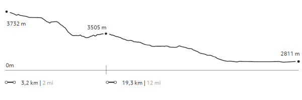
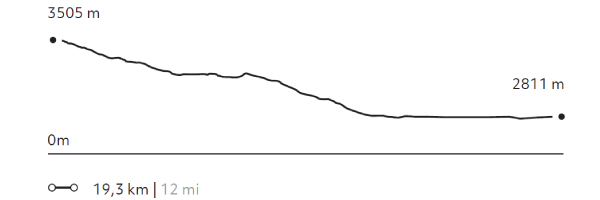
239 m 782 ft
-1.160 m -3.806 ft
3.732 m 12.244 ft
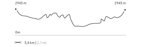
2.811 m 9.222 ftElevation Profile
Silvayoc
Quechua
-
Self Guided
-
Easy
-
Half-day
The hike visits archaeological sites with great historical value helping us connect with those who once inhabited the Sacred Valley.
More details >Silvayoc


-
Exploration Path
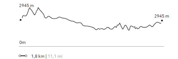
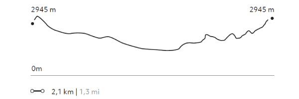
Explora’s plot is located in Urubamba, considered Peru’s archaeological capital. This 32-hectare area –encompassing four ancient properties– includes archaeological evidence that proves occupation since pre-Incan times. The hike visits archaeological sites with great historical value helping us connect with those who once inhabited the Sacred Valley.
28 m 99 ft
-28 m -99 ft
2.939 m 9.642 ft
2.914 m 9.560 ftElevation Profile
Huayabamba
Quechua
-
Self Guided
-
Easy
-
Half-day
Riding a bicycle through the explora’s surroundings is a good option for getting to know Urquillos, as well as getting to Huayllamba...
More details >Huayabamba
-
Exploration Path
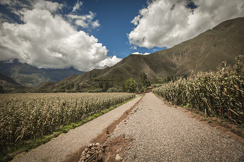
Riding a bicycle through the Explora’s surroundings is a good option for getting to know Urquillos, as well as getting to Huayllamba by following the course of the Urubamba River. This tour shows the farming nature of the area and the contrasts between one locality and the other.
267 m 876 ft
-275 m -902 ft
2.969 m 9.741 ft
2.867 m 9.406 ftElevation Profile
Urquillos
Quechua
-
Self Guided
-
Easy
-
Half-day
A good way to get to know the surroundings of Explora Valle Sagrado and the community of Urquillos, a hike where the active use of...
More details >Urquillos
-
Exploration Path
A good way to get to know the surroundings of Explora Valle Sagrado and the community of Urquillos, a hike where the active use of irrigation channels for local farming can be observed, where the quiet way of life and work prevailing in this area of the Sacred Valley is maintained.
72 m 236 ft
-71 m -233 ft
2.951 m 9.682 ft
2.904 m 9.528 ftElevation Profile
La Capilla
Quechua
-
Self Guided
-
Easy
-
Half-day
This hike up to the chapel located on the hillside behind the hotel offers views of the valley, cornfields and mountains. The chapel...
More details >La Capilla
-
Exploration Path
This hike up to the chapel located on the hillside behind the hotel offers views of the valley, cornfields and mountains. The chapel is a sample of the religious syncretism of this area where Catholicism and local traditions converge.
143 m 469 ft
-143 m -469 ft
2.948 m 9.672 ft
2.891 m 9.485 ftElevation Profile
Ayni
Quechua
-
Overland
-
Easy
-
Full-day
We will visit the community of Huayllafara in the valley of Lamay, stopping along the way for a briefing on existing conservation projects...
More details >Ayni

-
Exploration Path
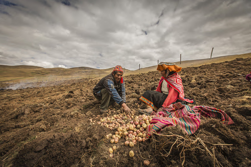
We will visit the community of Huayllafara in the valley of Lamay, stopping along the way for a briefing on existing conservation projects and then reaching the hike’s starting point. Once in the community, we will take part in farm work –based on the Andean calendar– learning about different local plants and crops. We will also get to know farming tools and techniques passed down through generations. Lunch will be prepared by community members using local produce.
Valle Sur
Quechua
-
Overland
-
Easy
-
Full-day
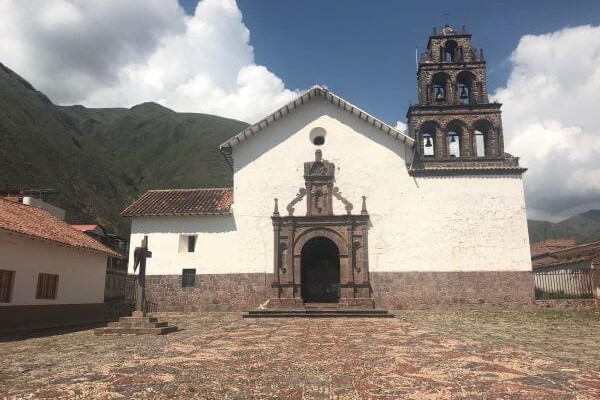
This exploration reveals the influence of the Spanish conquest in the region, embedded in art and in the religious syncretism that resulted...
More details >Valle Sur
-
Exploration Path
This exploration reveals the influence of the Spanish conquest in the region, embedded in art and in the religious syncretism that resulted from the encounter of these cultures. We begin by touring the first of three Canincunca churches that we visit in this exploration. We then walk to the Huaro church and take a van to the Andahuaylillas church, where we tour the choir and the museum. Next, we hop on a van towards an Inca road, where we take a light trek to a wetland, perfect for bird watching and having lunch. Finally, we take the van to the Tipón archaeological center, a token of the Inca’s knowledge of fluid power.
Machu-Picchu
Quechua
-
Overland
-
Easy
-
Full-day
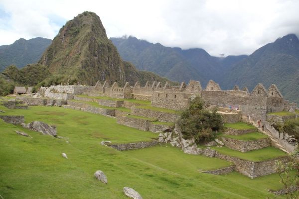
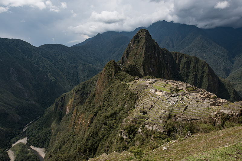
We explore the famous historical sanctuary of Machu Picchu, one of the most impressive architectural expressions of the Inca civilization.
More details >Machu-Picchu
-
Exploration Path
We explore the famous historical sanctuary of Machu Picchu, one of the most impressive architectural expressions of the Inca civilization. We leave the hotel towards the train station in Ollantaytambo, where we take the train to the town of Aguas Calientes to ascend to Machu Picchu by bus. We explore this magical place for approximately three hours. This version does not include the hike to Puerta del Sol or Inti Punku. Once we’ve visited the sanctuary, we leave Machu Picchu and head towards the station to take the train back.
*This exploration combines Explora services with third-party services, meaning it must be confirmed with our booking team at least 50 days before the visit. It has an additional cost of USD $400 for adults and USD $350 for children (up to 11 years). The exploration to Machu Picchu is provided through the rail company Perú Rail in the “Vistadome” or “Expedition” modality, depending on availability. The entrance to Machu Picchu must be at 11am.
To make your reservation, contact us by email at reserve@explora.com or phone us at +56 2 2395 2800.
Between Mountains
Quechua
-
Combination
-
Moderate
-
Full-day
From the heights of the slopes of Sacred Valley we will descend by bicycle on a track in good condition. The journey offers...
More details >Between Mountains
-
Exploration Path
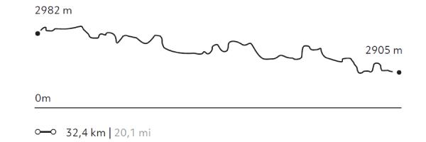
From the heights of the slopes of Sacred Valley we will descend by bicycle on a track in good condition. The journey offers very interesting views towards the mountains and the Urubamba river. Once the descent is finished, we will continue along a land parallel to the river, an area full of orchards and cornfields, as well as a great density of Inca terrace. We continue walking through Ollantaytambo, ascending a path with vegetation next to houses and orchards. The Pumamarca remains pose a conundrum to archeologists and explorers: their origins and functions are still unknown.
814 m 2.671 ft
-1.072 m -3.517 ft
3.510 m 11.516 ft
2.811 m 9.222 ftElevation Profile
Machu-Picchu Inti Punku
Quechua
-
Hike
-
Moderate
-
Full-day
We begin in Ollantaytambo, where we take the train to Aguas Calientes. There, we take the bus up to Machu Picchu. We walk towards...
More details >Machu-Picchu Inti Punku

-
Exploration Path
We begin in Ollantaytambo, where we take the train to Aguas Calientes. There, we take the bus up to Machu Picchu. We walk towards Inti Punku or Puerta del Sol, an old check point, to enter the citadel. Then we descend and explore this magical place for approximately three hours. Once we have thoroughly explored the sanctuary, we leave Machu Picchu and head towards the station to take the train back.
*This exploration combines Explora services with third-party services, meaning it must be confirmed with our booking team at least 50 days before the visit. It has an additional cost of USD $400 for adults and USD $350 for children (up to 11 years). The exploration to Machu Picchu is provided through the rail company Perú Rail in the “Vistadome” or “Expedition” modality, depending on availability. The entrance to Machu Picchu must be at 11am.
To make your reservation, contact us by email at reserve@explora.com or phone us at +56 2 2395 2800.
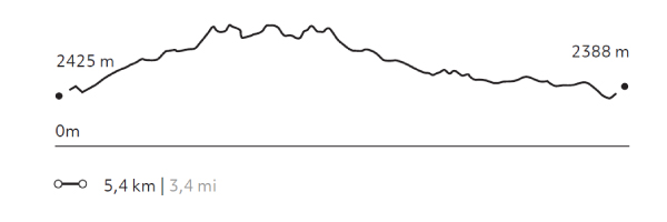
695 m 2.280 ft
-698 m -2.290 ft
2.720 m 8.924 ft
2.388 m 7.835 ftElevation Profile
Cuesta del Sapo
Quechua
-
Bike
-
Moderate
-
Half-day
From the heights of the Sacred Valley’s slopes we descend over a track in good conditions. The road offers very interesting views to the mountains...
More details >Cuesta del Sapo

-
Exploration Path
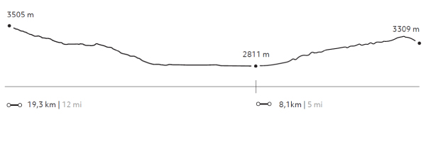
From the heights of the Sacred Valley’s slopes we descend over a track in good conditions. The road offers very interesting views to the mountains and the Urubamba river. Once downhill, we will continue bordering the river through an area of cornfields and orchards and densely packed Inca terraces.
163 m 535 ft
-858 m -2.815 ft
3.505 m 11.499 ft
2.811 m 9.222 ftElevation Profile
Rio Urubamba
Quechua
-
Bike
-
Easy
-
Half-day
The road used for this exploration goes down the south side of the Urubamba River, a quiet area of cornfields, old haciendas and manors from...
More details >Rio Urubamba
-
Exploration Path
The road used for this exploration goes down the south side of the Urubamba River, a quiet area of cornfields, old haciendas and manors from the 19th and 20th centuries. This bike ride is recommended for families wishing to take a long walk or for those who want to take on a sport.
858 m 2.815 ft
-928 m -3.045 ft
2.996 m 9.829 ft
2.811 m 9.222 ftElevation Profile
Pumatambo
Quechua
-
Hike
-
Moderate
-
Full-day
The first part of the exploration is right through the living Inca city of Ollantaytambo. Then, we ascend to the archaeological site to...
More details >Pumatambo
-
Exploration Path
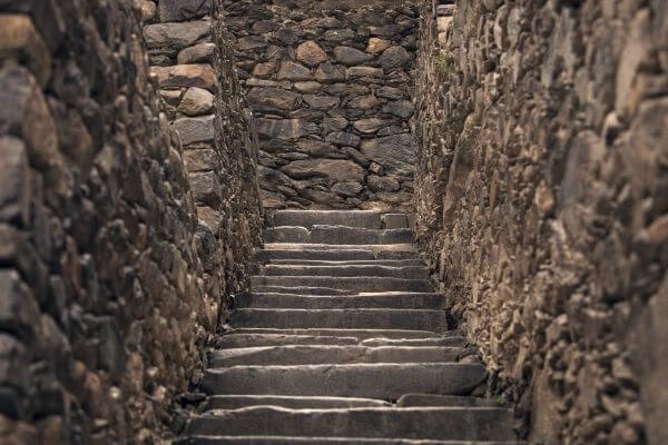
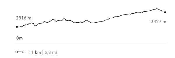
The first part of the exploration is right through the living Inca city of Ollantaytambo. Then, we ascend to the archaeological site to get to know its terraces, the ceremonial center and the Royal House. The second part is a hike through the Patacancha valley, ascending progressively along a path to the vestiges of Pumamarca, one of the most enigmatic archaeological sites in the region.
828 m 2.717 ft
-360 m -1.181 ft
3.427 m 11.243 ft
2.816 m 9.239 ftElevation Profile
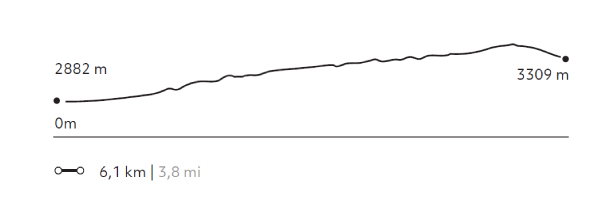
Pumamarca
Quechua
-
Hike
-
Moderate
-
Half-day
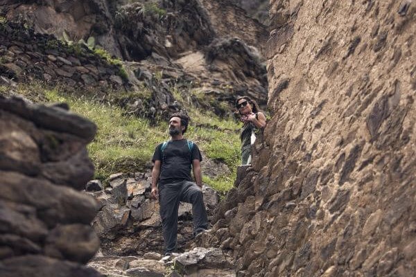
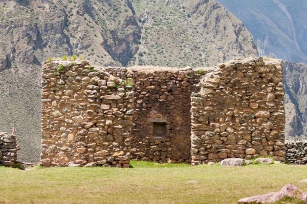
This exploration is an opportunity to discover one of the area’s most puzzling and isolated Inca remains. The walk takes us through the...
More details >Pumamarca
-
Exploration Path
This exploration is an opportunity to discover one of the area’s most puzzling and isolated Inca remains. The walk takes us through the Patacancha valley. The walk begin outside of Ollantaytambo, ascending through a verdant trail along local farm houses and orchards. The Pumamarca remains pose a conundrum to archeologists and explorers: their origins and functions are still unknown.
651 m 2.136 ft
-214 m -702 ft
3.427 m 11.243 ft
2.882 m 9.455 ftElevation Profile
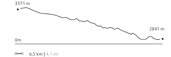
Salineras
Quechua
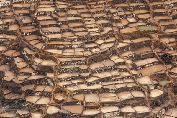
-
Hike
-
Moderate
-
Half-day
Hiking begins visiting the colonial town of Maras. After crossing the village, the trail descends among potato fields to the community’s salt...
More details >Salineras
-
Exploration Path
Hiking begins visiting the colonial town of Maras. After crossing the village, the trail descends among potato fields to the community’s salt mines.
Not recommended for travelers with fear of heights.
162 m 531 ft
-681 m -2.234 ft
3.371 m 11.060 ft
2.841 m 9.321 ftElevation Profile
-
Other options: