Sacred Valley
Machu Picchu & Sacred Valley, Peru
Explorations in
Sacred Valley
Activity
Difficulty
Areas
Pirka
Suni
-
 Overland
 -
Easy
-
Full-day
This route first takes us to Ollantaytambo, also known as the “living Inca city”. From there we travel to the archaeological site of Moray...
More details >Pirka


-
Exploration Path
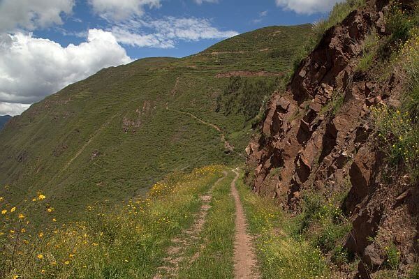
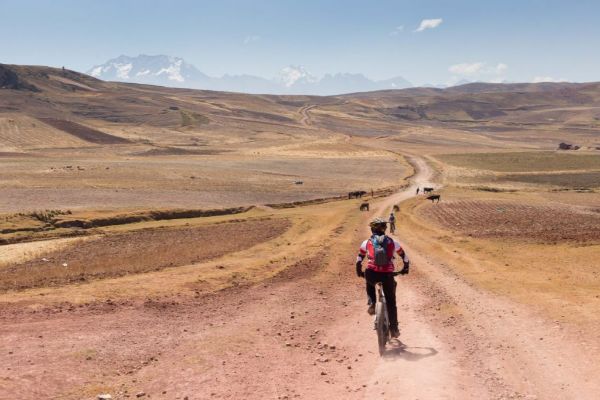
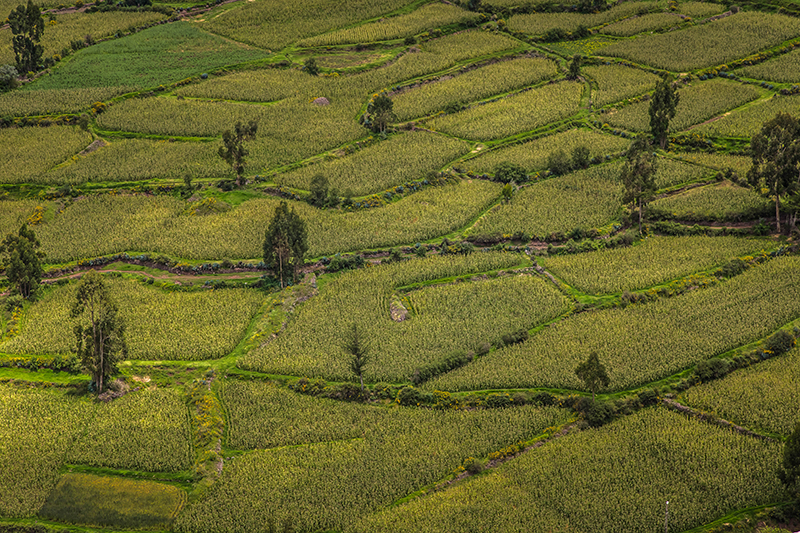
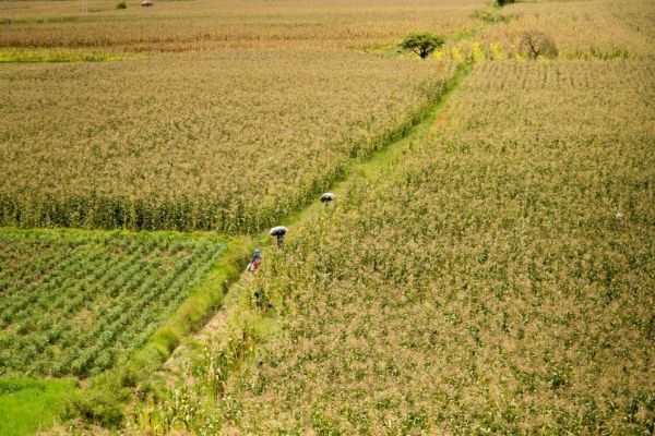
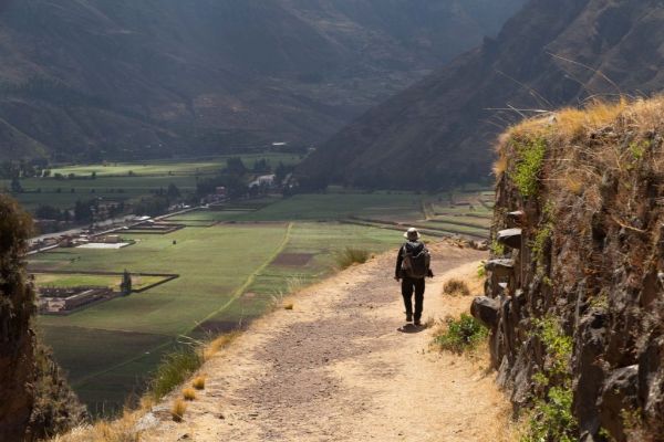
This route first takes us to Ollantaytambo, also known as the “living Inca city”. From there we travel to the archaeological site of Moray, a laboratory of experimental farming where different microclimates are used to grow crops. From here we continue to Maras and a large lagoon, an ideal place to take a stroll and have lunch, to then follow to the town of Chinchero. The road crosses several fields where we will see farmers working or looking after their animals.
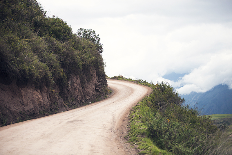
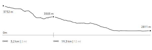
Cuesta del Sapo
Quechua
-
Bike
-
Moderate
-
Half-day
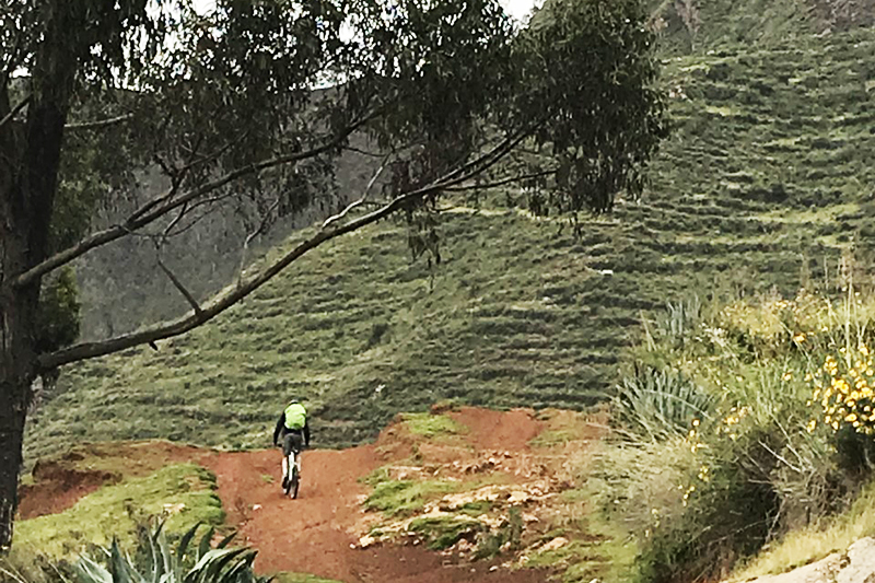
From the heights of the Sacred Valley’s slopes we descend over a track in good conditions. The road offers very interesting views to the mountains...
More details >Cuesta del Sapo


-
Exploration Path
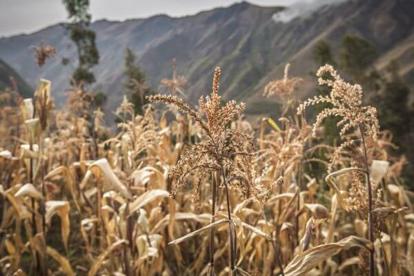
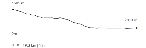
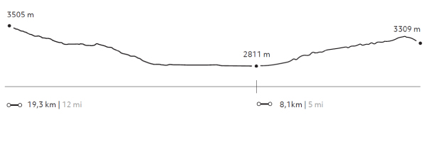
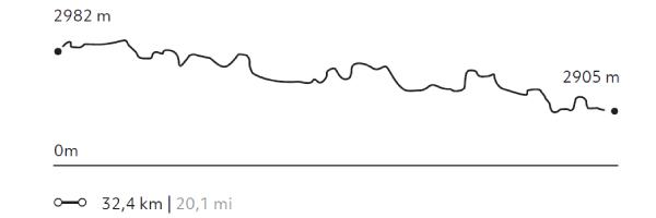
From the heights of the Sacred Valley’s slopes we descend over a track in good conditions. The road offers very interesting views to the mountains and the Urubamba river. Once downhill, we will continue bordering the river through an area of cornfields and orchards and densely packed Inca terraces.
163 m 535 ft
-858 m -2.815 ft
3.505 m 11.499 ft
2.811 m 9.222 ftElevation Profile
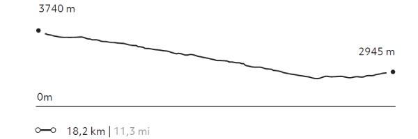
Huayna Kolka
Suni
-
Bike
-
Moderate
-
Half-day
After visiting the archaeological site of Machu Kolka, we get on our bikes and begin a descent among trees and adobe houses towards...
More details >Huayna Kolka
-
Exploration Path
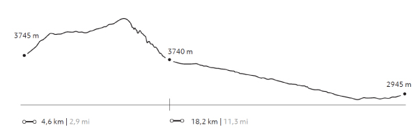
After visiting the archaeological site of Machu Kolka, we get on our bikes and begin a descent among trees and adobe houses towards the town of Racchi. There, we pedal in ascent towards the viewpoint of Huayna Kolka to contemplate the valley. We descend by a winding dirt road to Huayllabamba. At this point, we skirt around different crop fields until we reach explora.
403 m 1.322 ft
-1.198 m -3.930 ft
3.740 m 12.270 ft
2.867 m 9.406 ftElevation Profile
Huaypo Views
Suni
-
Bike
-
Advanced
-
Full-day
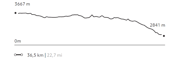
This exploration crosses the farmlands of Chinchero, visiting vegetable gardens, small farms and villages. It takes the traveler...
More details >Huaypo Views

-
Exploration Path
This exploration crosses the farmlands of Chinchero, visiting vegetable gardens, small farms and villages. It takes the traveler to the remains of the Moray experimental crop center, the colonial town of Maras and its Inca salt-mines, to finalize with a descent to the Urubamba River. This exploration is recommended for travelers in good physical conditions and experienced in mountain biking.
735 m 2.411 ft
-1.557 m -5.108 ft
3.710 m 12.172 ft
2.841 m 9.321 ftElevation Profile
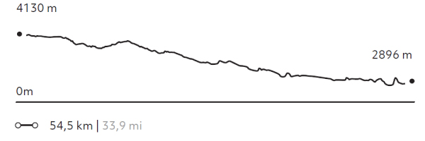
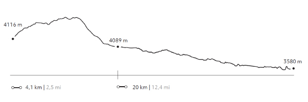
Qenqo
Puna
-
Bike
-
Expert
-
Full-day
The exploration begins in the heights of the pampas and then descends – over a vehicle road – among Quechua communities and farmlands...
More details >Qenqo

-
Exploration Path
The exploration begins in the heights of the pampas and then descends – over a vehicle road – among Quechua communities and farmlands with views to the Sacred Valley and Pisac. In the afternoon, the ride goes follows the south side of the Urubamba river among cornfields, old haciendas and manors from the 19th and 20th century.
997 m 3.271 ft
-2.209 m -7.247 ft
4.130 m 13.550 ft
2.896 m 9.501 ftElevation Profile
Moray Avalanche
Quechua
-
Combination
-
Moderate
-
Full-day
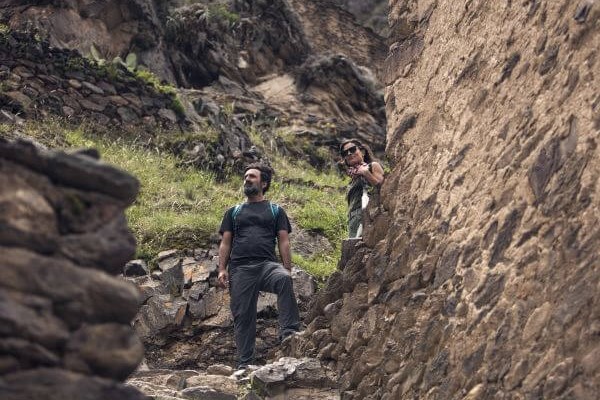
Our exploration begins with a hike through a community located in the hills, and descends to the Inca ruins of Moray, a special site...
More details >Moray Avalanche

-
Exploration Path
Our exploration begins with a hike through a community located in the hills, and descends to the Inca ruins of Moray, a special site that was used as an agricultural research center. Afterwards, we continue on bicycle, from the top of the slopes of the valley we descend on a wide path kept in good condition. The journey offers interesting views towards the mountains and the Urubamba river. Once the descent is finished, we continue along land parallel to the river, an area full of orchards and cornfields, as well as a great density of Inca terraces.
239 m 782 ft
-1.160 m -3.806 ft
3.732 m 12.244 ft
2.811 m 9.222 ftElevation Profile
Between Mountains
Quechua
-
Combination
-
Moderate
-
Full-day
From the heights of the slopes of Sacred Valley we will descend by bicycle on a track in good condition. The journey offers...
More details >Between Mountains
-
Exploration Path
From the heights of the slopes of Sacred Valley we will descend by bicycle on a track in good condition. The journey offers very interesting views towards the mountains and the Urubamba river. Once the descent is finished, we will continue along a land parallel to the river, an area full of orchards and cornfields, as well as a great density of Inca terrace. We continue walking through Ollantaytambo, ascending a path with vegetation next to houses and orchards. The Pumamarca remains pose a conundrum to archeologists and explorers: their origins and functions are still unknown.
814 m 2.671 ft
-1.072 m -3.517 ft
3.510 m 11.516 ft
2.811 m 9.222 ftElevation Profile
The Mita
Suni
-
Combination
-
Moderate
-
Full-day
We leave by van to Chinchero, where we start an uphill hike through crop fields overlooking the valley and the snowy peaks that crown...
More details >The Mita
-
Exploration Path
We leave by van to Chinchero, where we start an uphill hike through crop fields overlooking the valley and the snowy peaks that crown the mountains. We walk to the Machu Kolka archaeological site, formerly used as a product storage warehouse. We visit the place and enjoy a privileged view of the valley where we will have lunch. Then, we get on our bikes and start our descent down a winding dirt road to Huayllabamba. At this point, we skirt around different crop fields and bike back to Explora.
639 m 2.096 ft
-1.441 m -4.728 ft
3.933 m 12.904 ft
2.867 m 9.406 ftElevation Profile
InkaTracks
Puna
-
Combination
-
Expert
-
Full-day
During the morning, this exploration considers a 3,3 mi walk over a mountain trail with 360º views to Cusco and the Sacred Valley.
More details >InkaTracks
-
Exploration Path
During the morning, this exploration considers a 3,3 mi walk over a mountain trail with 360º views to Cusco and the Sacred Valley. The descent is through potato plantations and pampas where shepherds tend their animals. In the afternoon, biking starts on the heights of the pampas, then going down through Quechua communities and farmlands, with views to the Sacred Valley.
1.208 m 3.963 ft
-2.484 m -8.150 ft
4.263 m 13.986 ft
3.738 m 12.264 ftElevation Profile
Machu-Picchu
Quechua
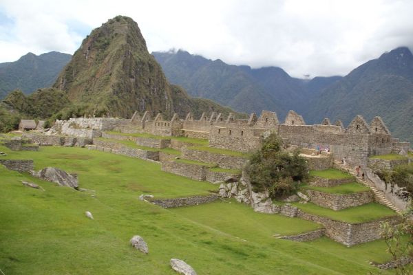
-
Overland
-
Easy
-
Full-day
We explore the famous historical sanctuary of Machu Picchu, one of the most impressive architectural expressions of the Inca civilization.
More details >Machu-Picchu
-
Exploration Path
We explore the famous historical sanctuary of Machu Picchu, one of the most impressive architectural expressions of the Inca civilization. We leave the hotel towards the train station in Ollantaytambo, where we take the train to the town of Aguas Calientes to ascend to Machu Picchu by bus. We explore this magical place for approximately three hours. This version does not include the hike to Puerta del Sol or Inti Punku. Once we’ve visited the sanctuary, we leave Machu Picchu and head towards the station to take the train back.
*This exploration combines Explora services with third-party services, meaning it must be confirmed with our booking team at least 50 days before the visit. It has an additional cost of USD $400 for adults and USD $350 for children (up to 11 years). The exploration to Machu Picchu is provided through the rail company Perú Rail in the “Vistadome” or “Expedition” modality, depending on availability. The entrance to Machu Picchu must be at 11am.
To make your reservation, contact us by email at reserve@explora.com or phone us at +56 2 2395 2800.
Cusco
Suni
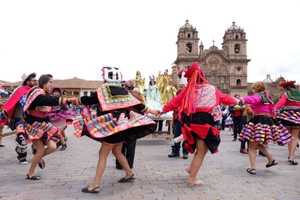
-
Overland
-
Easy
-
Full-day
This exploration shows the best of Cusco in one day. We will descend from the fortress of Saqsaywaman down crossing the al leys...
More details >Cusco
-
Exploration Path
This exploration shows the best of Cusco in one day. We will descend from the fortress of Saqsaywaman down crossing the al leys of the colonial quarter of San Blas to the main square. After lunch, the traveler can continue walking through Cusco with one of our guides or on his/her own. The temple of Corincan cha, on which the Santo Domingo convent was built, Museum of Pre-Columbian Art, the San Pedro Market, some Art Galleries or the hundreds of souvenirs stores are some of the options we recommend. * Tickets to the evening atractions are not included.
Valle Sur
Quechua
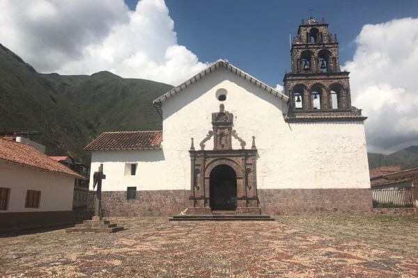
-
Overland
-
Easy
-
Full-day
This exploration reveals the influence of the Spanish conquest in the region, embedded in art and in the religious syncretism that resulted...
More details >Valle Sur
-
Exploration Path
This exploration reveals the influence of the Spanish conquest in the region, embedded in art and in the religious syncretism that resulted from the encounter of these cultures. We begin by touring the first of three Canincunca churches that we visit in this exploration. We then walk to the Huaro church and take a van to the Andahuaylillas church, where we tour the choir and the museum. Next, we hop on a van towards an Inca road, where we take a light trek to a wetland, perfect for bird watching and having lunch. Finally, we take the van to the Tipón archaeological center, a token of the Inca’s knowledge of fluid power.
Rio Urubamba
Quechua
-
Bike
-
Easy
-
Half-day
The road used for this exploration goes down the south side of the Urubamba River, a quiet area of cornfields, old haciendas and manors from...
More details >Rio Urubamba
-
Exploration Path
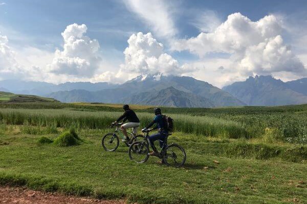
The road used for this exploration goes down the south side of the Urubamba River, a quiet area of cornfields, old haciendas and manors from the 19th and 20th centuries. This bike ride is recommended for families wishing to take a long walk or for those who want to take on a sport.
858 m 2.815 ft
-928 m -3.045 ft
2.996 m 9.829 ft
2.811 m 9.222 ftElevation Profile
Pisac
Suni
-
Overland
-
Easy
-
Half-day
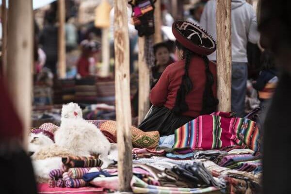
Known for its remarkable ruins, as well as for its colorful crafts market, the village of Pisac bears witness to the accomplishments and mysteries...
More details >Pisac
-
Exploration Path
Known for its remarkable ruins, as well as for its colorful crafts market, the village of Pisac bears witness to the accomplishments and mysteries of the Inca civilization.
This exploration allows travellers to discover, by foot, this key enclave of the Sacred Valley, showing an integral vision of the Inca cosmovision.
Chinchero
Suni
-
Overland
-
Easy
-
Half-day
Just 1 hour away from explora, between Urubamba and Cuzco, the village of Chinchero (3762 masl) is believed to be the birthplace...
More details >Chinchero
-
Exploration Path
Just 1 hour away from explora, between Urubamba and Cuzco, the village of Chinchero (3762 masl) is believed to be the birthplace of the Sacred Valley’s textile craftsmanship, as well as a hub for local trade.
This exploration takes travellers through the colonial streets of Chinchero by foot, visiting the village’s adobe church and discovering the unique murals preserved within.
-
Other options: