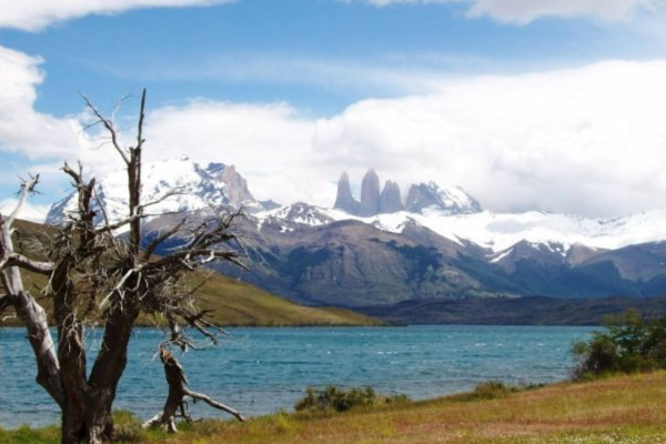
Torres del Paine
Patagonia, Chile
Explorations in
Torres del Paine
Activity
Difficulty
Areas
AONIKENK
Estepa
-
 Hike
Hike -
Moderate
-
Half-day
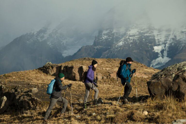
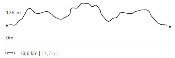
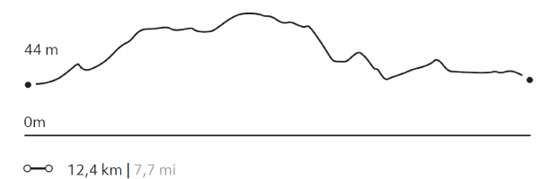
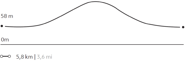
We travel by van to the eastern sector of the park, where we hike, exploring the wildlife. During the walk, we visit a cave...
More details >AONIKENK


-
Exploration Path
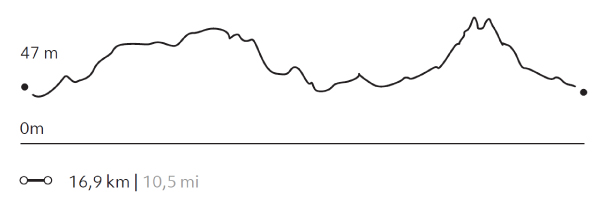
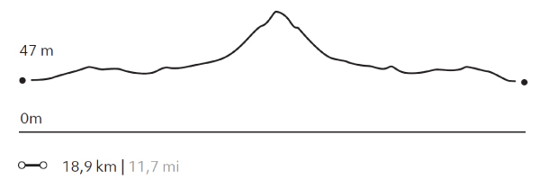
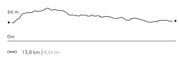
We travel by van to the eastern sector of the park, where we hike, exploring the wildlife. During the walk, we visit a cave with paintings that are over 4,000 years old. We can observe the geese, ducks and swans in the lagoons that are on the way. The terrain has various ascents and descents without steep slopes. Return by van.
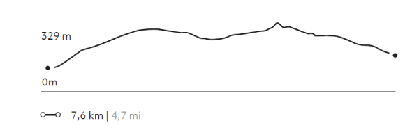
303 m 994 ft
-237 m -778 ft
329 m 1079 ft
95 m 312 ftElevation Profile
CAMPAMENTO BRITANICO
Glaciar
-
Hike
-
Expert
-
Full-day
This exploration is one of the stretches of the W. We cross Pehoé Lake by catamaran to the Paine Grande refuge where we start our trek...
More details >CAMPAMENTO BRITANICO

-
Exploration Path
This exploration is one of the stretches of the W. We cross Pehoé Lake by catamaran to the Paine Grande refuge where we start our trek to the heart of the Francés Valley. We arrive at the Britanico viewpoint while trekking through lenga forests, approaching the Paine Horns.
872 m 2861 ft
-872 m -2861 ft
712 m 2.336 ft
39 m 128 ftElevation Profile
GUARDAS
Glaciar
-
Hike
-
Expert
-
Full-day
We cross Pehoé Lake on a catamaran to the Paine Grande refuge where we begin our trek to the Grey refuge...
More details >GUARDAS
-
Exploration Path
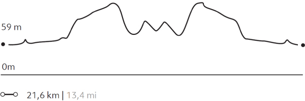
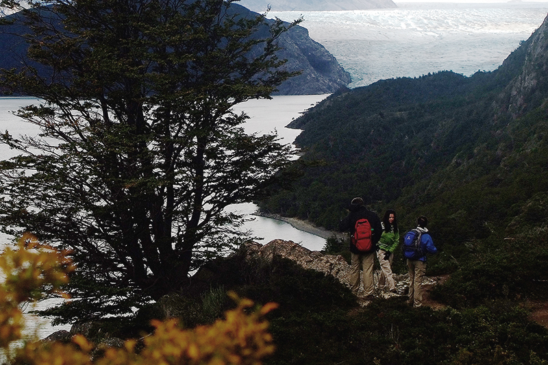
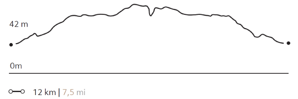
We cross Pehoé Lake on a catamaran to the Paine Grande refuge where we begin our trek to the Grey refuge. From there, we walk towards the viewpoint at Guardas camp with panoramic views of the glacier. We return to the refuge. There we board a boat that will take us to the glacier and then leave us on the other side of Grey Lake. We walk back to the van.
*Browsing is subject to the availability of Explora's external operator.
857 m 2812 ft
-849 m -2785 ft
306 m 1.004 ft
39 m 128 ftElevation Profile
VALLE DEL RÍO PINGO
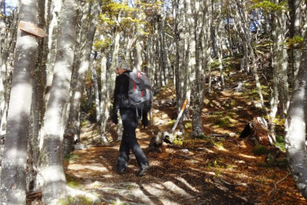
Bosque
-
Hike
-
Advanced
-
Full-day
We travel by van to the Grey Lake refuge where we start walking along the Pingo River. We cross the river to reach forests...
More details >VALLE DEL RÍO PINGO

-
Exploration Path
We travel by van to the Grey Lake refuge where we start walking along the Pingo River. We cross the river to reach forests through which the Paine Grande can be seen. We return on the same road to the refuge to get on the van and return to Explora.
745 m 2444 ft
-745 m -2444 ft
313 m 1.027 ft
57 m 187 ftElevation Profile
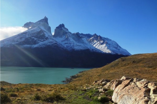
CUERNOS
Encuentro
-
Hike
-
Advanced
-
Full-day
We travel by van to the Cerro Paine estancia, where we begin our trek. We walk along Nordenskjöld Lake...
More details >CUERNOS
-
Exploration Path
We travel by van to the Cerro Paine estancia, where we begin our trek. We walk along Nordenskjöld Lake until we reach the uphill path of the Bader Valley with views of the horns, the Pehoé, Sarmiento and Nordenskjöld lakes and the Almirante Nieto glacier.
664 m 2178 ft
-664 m -2178 ft
269 m 883 ft
123 m 404 ftElevation Profile
Cornisas
Encuentro
-
Hike
-
Advanced
-
Half-day
We walk towards the Paine River until we reach the cliffs that give name to this exploration. As we gain altitude...
More details >Cornisas
-
Exploration Path
We walk towards the Paine River until we reach the cliffs that give name to this exploration. As we gain altitude, we have panoramic views from different perspectives. We see the Paine River, Pehoé Lake and at the top, we can contemplate the Paine mountain range and the surrounding valleys.
414 m 1358 ft
-427 m -1401 ft
373 m 1.224 ft
28 m 92 ftElevation Profile
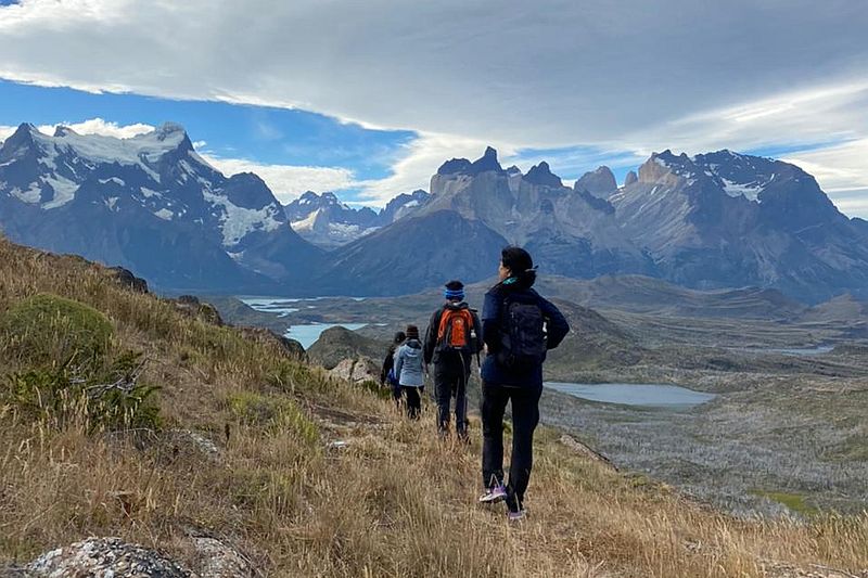
PLATEAU
Glaciar
-
Hike
-
Advanced
-
Full-day
We travel on our catamaran to the Francés Valley where we start our trek to the plateau. We arrive at the Italian Camp...
More details >PLATEAU
-
Exploration Path
We travel on our catamaran to the Francés Valley where we start our trek to the plateau. We arrive at the Italian Camp and then to an overlook from where we have privileged views of the towers and the Francés Glacier. This hike follows a rocky path through the moraine of the glacier.
700 m 2297 ft
-700 m -2297 ft
485 m 1.591 ft
39 m 128 ftElevation Profile
ALTO DEL TORO
Encuentro
-
Hike
-
Moderate
-
Full-day
We travel by van to a steep path facing the Paine River. We begin our trek towards the mountain range passing through an old forest...
More details >ALTO DEL TORO
-
Exploration Path
We travel by van to a steep path facing the Paine River. We begin our trek towards the mountain range passing through an old forest. We continue ascending to an overlook with unparalleled views of the Paine massif and the lakes that surround it. Then, we begin the descent towards the van.
570 m 1870 ft
-578 m -1896 ft
411 m 1.348 ft
38 m 125 ftElevation Profile
ORÍGENES
Encuentro
-
Hike
-
Moderate
-
Full-day
The hike starts at the lodge through a well-marked upward track, surrounded by low shrubs and ample views...
More details >ORÍGENES
-
Exploration Path
The hike starts at the lodge through a well-marked upward track, surrounded by low shrubs and ample views. Orchids follow along during the summertime. We get to see some hidden lagoons in the Torres del Paine National Park, condor nesting sites, and some forests. We get a front view of the Paine massif, until we get to the Sarmiento Chico Lake to examine rock formations of a protracted geological history. We return to the lodge by van.
515 m 1138 ft
-478 m -1568 ft
347 m 1.138 ft
64 m 210 ftElevation Profile
MIRADOR GREY
Glaciar
-
Hike
-
Easy
-
Full-day
We cross the Pehoé lake in the Explora catamaran towards the northwest bank. From there we will ascend to observe the Grey Glacier...
More details >MIRADOR GREY

-
Exploration Path
We cross the Pehoé lake in the Explora catamaran towards the northwest bank. From there we will ascend to observe the Grey Glacier and the extraordinary extension of the Southern Ice Fields. Then, we will return along the trail with views of icebergs. We return by catamaran to Explora.
488 m 1601 ft
-488 m -1601 ft
276 m 906 ft
39 m 128 ftElevation Profile
GLACIAR GREY
Glaciar

-
Hike
-
Moderate
-
Full-day
We cross the Pehoé Lake by catamaran to the Paine Grande refuge to cross one of the stretches of the W. Around the midpoint...
More details >GLACIAR GREY
-
Exploration Path
We cross the Pehoé Lake by catamaran to the Paine Grande refuge to cross one of the stretches of the W. Around the midpoint of the hike, we can see the Grey Glacier and the Southern Ice Fields. We continue walking to the beach of Grey Lake where we board a boat that brings us to the glacier and then leaves us on the other side of the lake. We walk along the beach and through a forest to the van.
*Browsing is subject to the availability of Explora's external operator.
538 m 1765 ft
-516 m -1693 ft
273 m 896 ft
29 m 95 ftElevation Profile
VALLE DEL FRANCÉS
Glaciar

-
Hike
-
Moderate
-
Full-day
We cross the Pehoé Lake by catamaran to the Paine Grande refuge where we start the trek. We enter the Francés Valley...
More details >VALLE DEL FRANCÉS
-
Exploration Path
We cross the Pehoé Lake by catamaran to the Paine Grande refuge where we start the trek. We enter the Francés Valley through a forest, cross the suspension bridge over the Francés River and continue to the Italian Camp. From there, we see the glacier and the granite peaks that frame the area. We return by the same trail.
473 m 1552 ft
-473 m -1552 ft
275 m 902 ft
39 m 128 ftElevation Profile
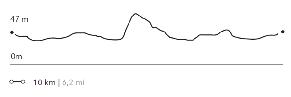
Juncales
Encuentro
-
Hike
-
Moderate
-
Full-day
We travel by van to an area rich in wildlife and birds. We begin the walk bordering a lagoon with reed islets...
More details >Juncales
-
Exploration Path
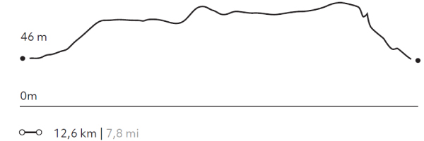
We travel by van to an area rich in wildlife and birds. We begin the walk bordering a lagoon with reed islets, where a natural habitat for different types of birds has been formed. We will continue walking with views of the Toro Lake and the hills of Castillo and Tenerife. We recommend this exploration to travelers interested in bird watching.
241 m 791 ft
-239 m -784 ft
85 m 279 ft
30 m 98 ftElevation Profile
FERRIER
Bosque
-
Hike
-
Expert
-
Half-day
We travel by van to the Grey Lake where we begin a demanding ascent during which we get views of the Lake...
More details >FERRIER
-
Exploration Path
We travel by van to the Grey Lake where we begin a demanding ascent during which we get views of the Lake and the huge ice mass of the South Ice Fields. We cross a forest and continue to the top with panoramic views of the Grey and Pehoé lakes. We descend and return by van.
612 m 2008 ft
-612 m -2008 ft
642 m 2.106 ft
56 m 184 ftElevation Profile
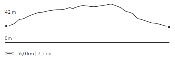
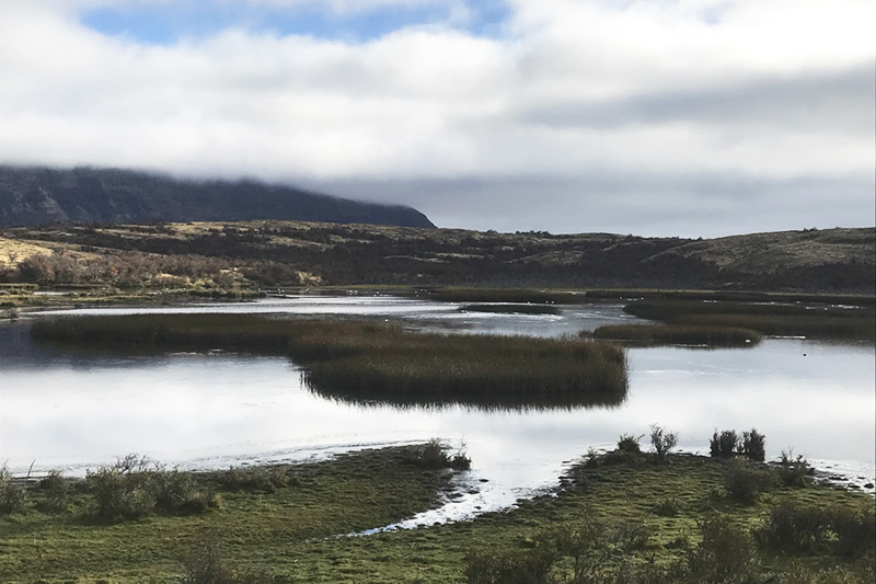
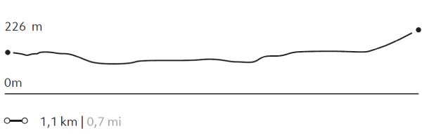
LAGUNA AZUL
Bosque
-
Hike
-
Easy
-
Half-day
We start at our quincho where we take a van to the Azul Lagoon. From there we walk around a wetland...
More details >LAGUNA AZUL
-
Exploration Path
We start at our quincho where we take a van to the Azul Lagoon. From there we walk around a wetland inhabited by multiple birds and cross the beach of the lagoon watching the Torres del Paine peek above the horizon. Finally, we arrive at a viewpoint and return by van.
22 m 72 ft
-16 m -52 ft
234 m 768 ft
223 m 732 ftElevation Profile
-
Other options: