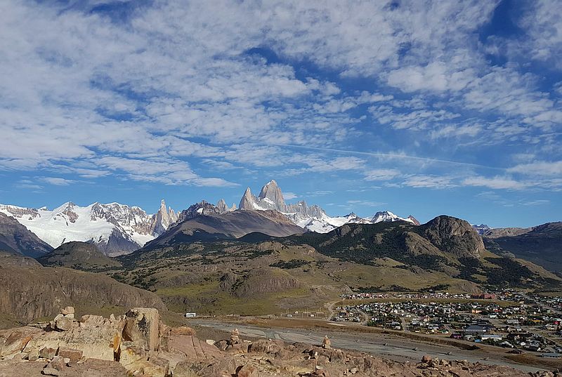
El Chaltén
Patagonia, Argentina
Explorations in
El Chaltén
Activity
Difficulty
Areas
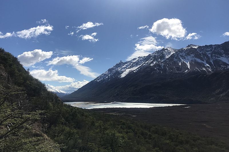
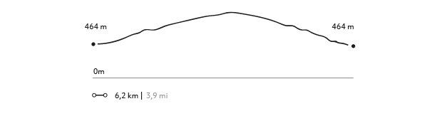
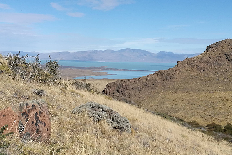
Laguna Cóndor
Los Huemules Conservation Reserve
-
 Self Guided
 -
Easy
-
Half-day
Un antiguo bosque de Lengas nos da la bienvenida a esta exploración, donde las aves se toman el protagonismo en varios sectores. El trayecto continúa con un leve ascenso por un filo de roca, que nos dará vistas y perspectivas únicas del valle del río de las Vueltas.
More details >Laguna Cóndor


-
Exploration Path
Un antiguo bosque de Lengas nos da la bienvenida a esta exploración, donde las aves se toman el protagonismo en varios sectores. El trayecto continúa con un leve ascenso por un filo de roca, que nos dará vistas y perspectivas únicas del valle del río de las Vueltas.
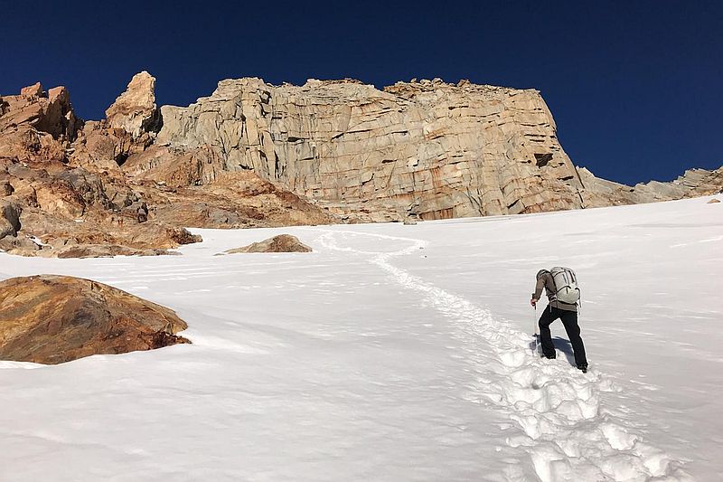
Paso del Cuadrado
Parque Nacional Los Glaciares
-
High Mountain Ascent
-
Advanced
-
Full-day
An ideal exploration for travelers wishing to have a different experience and perspective of the Patagonia.
More details >Paso del Cuadrado


-
Exploration Path
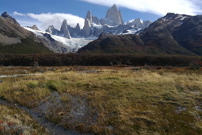
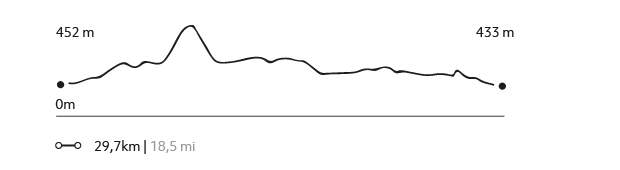
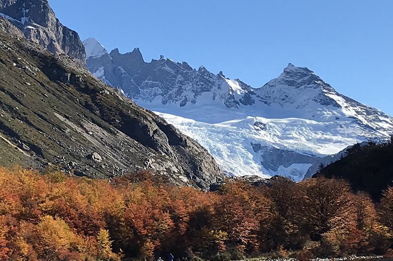
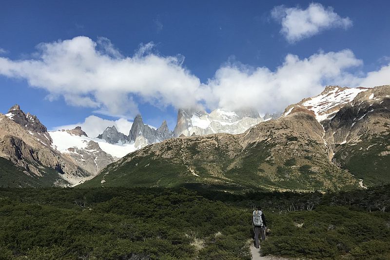
An ideal exploration for travelers wishing to have a different experience and perspective of the Patagonia. Surrounded by mountains, we will border the Eléctrico River through a Patagonia forest while enjoying a view to the Marconi Glacier. We then hike up a steep slope, leaving the forest behind and approaching the impressive mountains that seem to grow in height as we get closer. The north side of Mount Fitz Roy is waiting from a lookout that is the highest point of this exploration.
*Exploration subject to availability upon check-in.
1570 m 5151 ft
-1573 m -5161 ft
1.733 m 5.686 ft
449 m 1.473 ftElevation Profile
Cerro Madsen
Parque Nacional Los Glaciares
-
High Mountain Ascent
-
Expert
-
Full-day
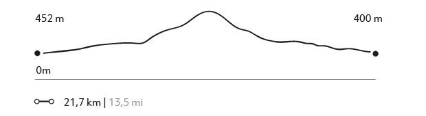
The ascent to Cerro Madsen, in the Fitz Roy area, is a perfect challenge for beginners in the mountains or for those who want to make their first summit in Patagonia.
More details >Cerro Madsen

-
Exploration Path
The ascent to Cerro Madsen, in the Fitz Roy area, is a perfect challenge for beginners in the mountains or for those who want to make their first summit in Patagonia and treat themselves to one of the most wonderful views in the world.
*Exploration subject to availability upon check-in.
1492 m 4895 ft
-1492 m -4895 ft
1.715 m 5.627 ft
452 m 1.483 ftElevation Profile
Los Valles
Parque Nacional Los Glaciares
-
Hike
-
Expert
-
Full-day
We cross the Blanco river valley, then we hike up to the los tres lagoon. Enjoy an impressive view of Mount Fitz Roy.
More details >Los Valles

-
Exploration Path
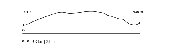
An Explora van will take us to the northernmost tip of the Los Glaciares National Park. From there, we begin crossing the Blanco River valley. We then hike up to the Los Tres Lagoon, enjoying an impressive view of Mount Fitz Roy. We then follow the valley to the Torre Lagoon. We reach El Chaltén after one day with different lookouts within the Los Glaciares National Park, to return to the lodge by van.
1222 m 4009 ft
-1249 m -4098 ft
1.178 m 3.865 ft
426 m 1.398 ftElevation Profile
El Filo
Los Huemules Conservation Reserve
-
Hike
-
Advanced
-
Full-day
El Filo
-
Exploration Path
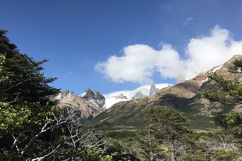
This exploration provides an overhead view of the north face of Mount Fitz Roy. We hike along the edge of one of the hills bordering the Diablo River, arriving to an altitude ecosystem with shrub-like forests, rocks, and sand fields. We get a great view of the glaciers, mountains, and valleys of the Diablo and Las Vueltas rivers.
574 m 1883 ft
-574 m -1883 ft
1.022 m 3.353 ft
463 m 1.519 ftElevation Profile
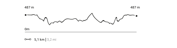
Corazón de la reserva
Los Huemules Conservation Reserve

-
Hike
-
Easy
-
Half-day
A brief hike from the lodge will take us to the entrance of the Los Huemules Nature Reserve forest.
More details >Corazón de la reserva
-
Exploration Path
A brief hike from the lodge will take us to the entrance of the Los Huemules Nature Reserve forest. Along the way are lenga and ñirres trees, and lagoons, as well as the company of native birds.
151 m 495 ft
-151 m -495 ft
567 m 1.860 ft
459 m 1.506 ftElevation Profile
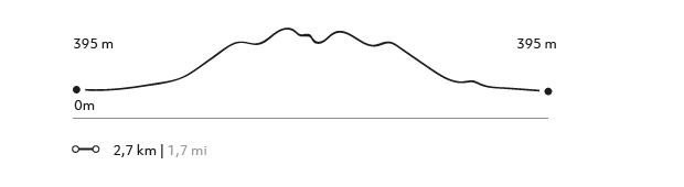
Los Cóndores
Parque Nacional Los Glaciares
-
Hike
-
Easy
-
Half-day
A walk that enters the Los Glaciares National Park with a connection and views to the Patagonia.
More details >Los Cóndores
-
Exploration Path
A walk that enters the Los Glaciares National Park with a connection and views to the Patagonia. We will enjoy breath-taking views to El Chaltén and the impressive Los Andes mountain range, while large condors follow us along the way.
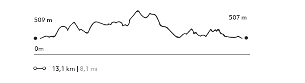
155 m 509 ft
-155 m -509 ft
509 m 1.670 ft
396 m 1.299 ftElevation Profile
Las Águilas
Parque Nacional Los Glaciares
-
Hike
-
Moderate
-
Full-day
Views to the Los Andes Mountain Range, the Viedma Lake, and surrounding mountain ranges.
More details >Las Águilas

-
Exploration Path
From El Chaltén we head up to the Los Glaciares National Park, with broad views to the Los Andes Mountain Range, the Viedma Lake, and surrounding mountain ranges. Shrublands and different types of birds can be sighed during the exploration.
271 m 889 ft
-271 m -889 ft
568 m 1.864 ft
396 m 1.299 ftElevation Profile
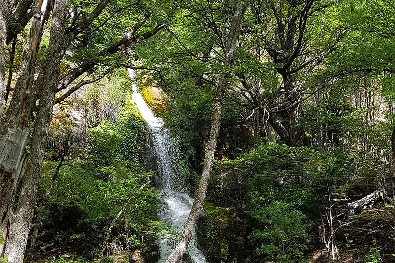
Valle Eléctrico
Los Huemules Conservation Reserve
-
Hike
-
Moderate
-
Full-day
The splashing of the Eléctrico River will follow along faithfully during the entire exploration, as we enjoy the contrasting views.
More details >Valle Eléctrico
-
Exploration Path
We walk from the lodge to enter a forest of lenga and ñirre trees, with the company of native birds in their habitat. The splashing of the Eléctrico River will follow along faithfully during the entire exploration, as we enjoy the contrasting views offered by the valley’s glaciers and hills.
Laguna del Diablo
Los Huemules Conservation Reserve
-
Hike
-
Advanced
-
Full-day
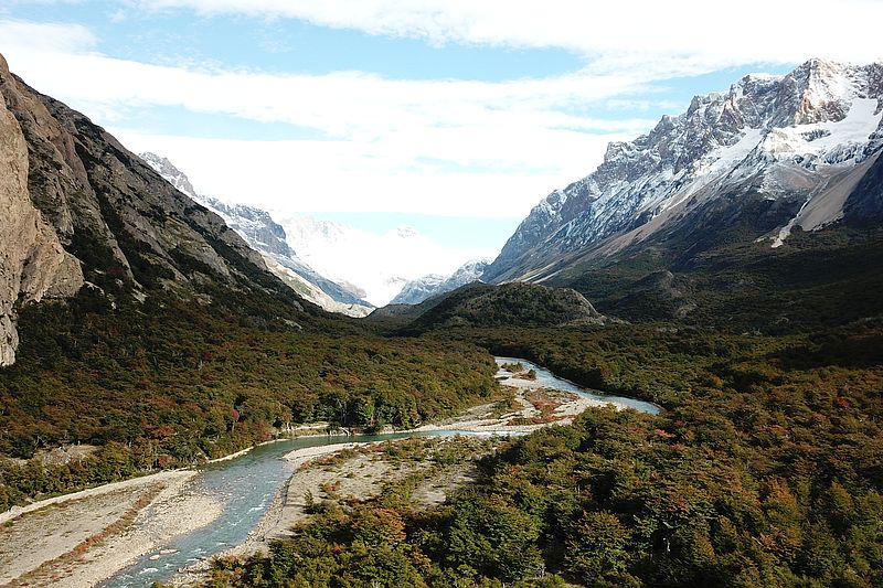
We start hiking through a trail surrounded by forests. We finally get views to the Cagliero Glacier and the Diablo Lagoon.
More details >Laguna del Diablo
-
Exploration Path
We start hiking through a trail surrounded by forests, with a view to the north face of Mount Fitz Roy. The route follows the Diablo River, where we can sight torrent ducks. As we go up, we get views to the Cagliero Glacier and the Diablo Lagoon. There are two options to return: Walking down to a spot to be picked up by a van or hiking back to the lodge.
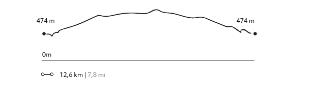
532 m 1745 ft
-525 m -1722 ft
812 m 2.664 ft
474 m 1.555 ftElevation Profile
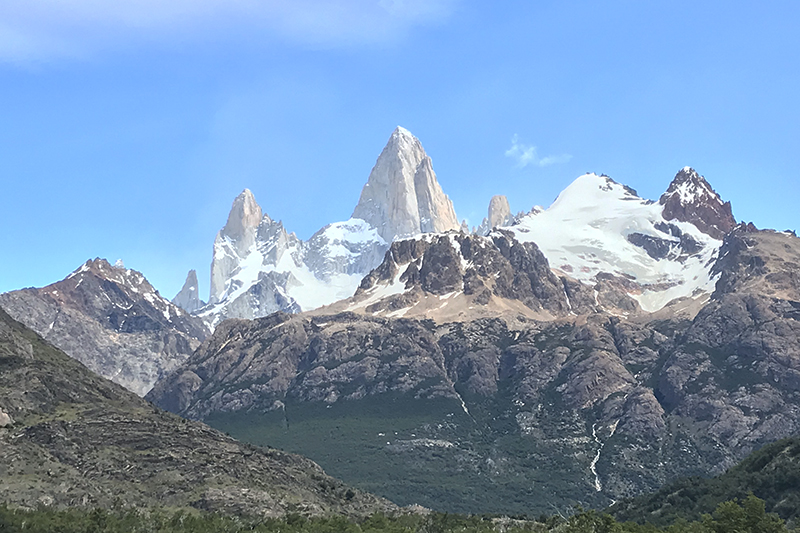
Mirador Fitz Roy
Parque Nacional Los Glaciares
-
Hike
-
Moderate
-
Full-day
In the Los Glaciares National Park, we cross the forests to get a great view of the Los Andes Mountain Range’s massifs.
More details >Mirador Fitz Roy
-
Exploration Path
We take a van from the lodge to the Los Glaciares National Park, where we cross the forests to get a great view of the Los Andes Mountain Range’s massifs. On clear days, we can watch Mount Fitz Roy and the Agujas Mermoz and Poincenot in all their glory. Finally, we reach the viewpoint to Mount Fitz Roy, with a unique perspective of this rock formation and all the mountains around it.
481 m 1578 ft
-483 m -1585 ft
772 m 2.533 ft
397 m 1.302 ftElevation Profile
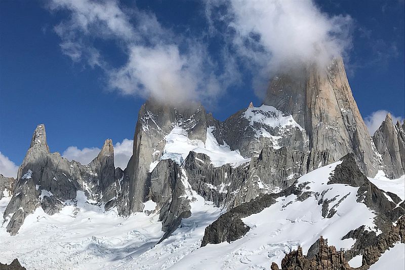
Mirador Cerro Torre
Parque Nacional Los Glaciares
-
Hike
-
Moderate
-
Full-day
In this exploration we can observe the marks of a retreating glacier and the impressive Los Andes Mountain Range.
More details >Mirador Cerro Torre
-
Exploration Path
We begin the hike from an access to the Los Glaciares National Park, taking an upward trail sided by bushes that provides ample views to the Torre Mountain. In this exploration we can observe the marks of a retreating glacier and the impressive Los Andes Mountain Range. We will also have time to photograph in detail the Patagonia landscapes and wildlife.
258 m 846 ft
-258 m -846 ft
613 m 2.011 ft
425 m 1.394 ftElevation Profile
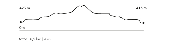
Bahía Tranquila
Lago del Desierto
-
Hike
-
Moderate
-
Full-day
Bahía Tranquila
-
Exploration Path
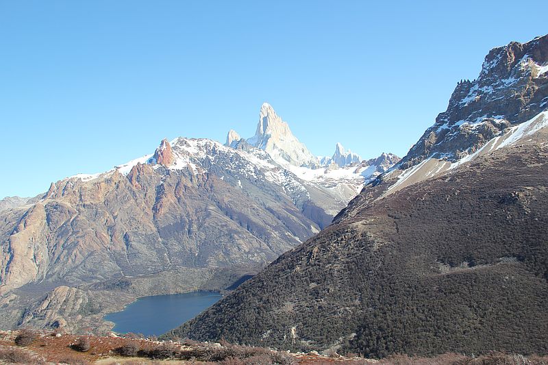
Following the Las Vueltas River amidst ancient forests, we will go to the northern area of El Chaltén. We will border the Desierto Lake, a watershed adjacent to forests and foothills of the Los Andes Mountain Range, to enjoy the views to two glaciers: Vespigniani and Huemul. Finally, we return through the same track to the van that will take us back to the lodge.
423 m 1388 ft
-415 m -1362 ft
593 m 1.946 ft
510 m 1.673 ftElevation Profile
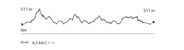
Lago del desierto
Lago del Desierto
-
Hike
-
Advanced
-
Full-day
We hike in the northernmost tip of the lake and take a rugged track through the forest, reaching some of the most unexplored parts of this area.
More details >Lago del desierto
-
Exploration Path
We take a van from the lodge to the south shore of the Desierto Lake. From there, we cross this historical lake while enjoying the view of the Vespigniani Glacier. We land on the northernmost tip of the lake and take a rugged track through the forest, reaching some of the most unexplored parts of this area. We reach the southern edge of the lake and finalize the exploration taking a van back to the lodge.
592 m 1942 ft
-588 m -1929 ft
660 m 2.165 ft
505 m 1.657 ftElevation Profile
Valle de Granito
Parque Nacional Los Glaciares
-
Hike
-
Moderate
-
Full-day
We walk to the Los Glaciares National Park through a trail surrounded by forests with views to the area’s glaciers.
More details >Valle de Granito
-
Exploration Path
We walk to the Los Glaciares National Park through a trail surrounded by forests with views to the area’s glaciers. We will get an ample view of the Los Andes Mountain Range, with Mount Fitz Roy taking center stage. We finalize the hike at the town of El Chaltén and take the van back to the lodge.
-
Other options: