Atacama
Desert & Altiplano, Chile
Explorations in
Atacama
Activity
Difficulty
Areas
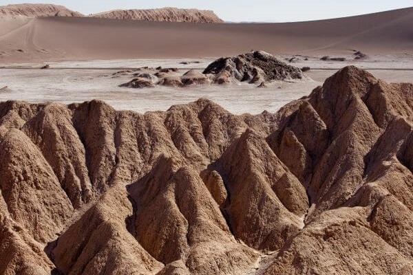
Cuchabrache
Cuenca del salar
-
 Hike
Hike -
Moderate
-
Half-day
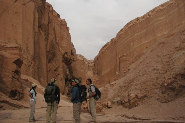
We take a van up to the Catarpe Valley, where we begin ascending the Salt Mountain Range. On the way, we’ll see petroglyphs...
More details >Cuchabrache


-
Exploration Path
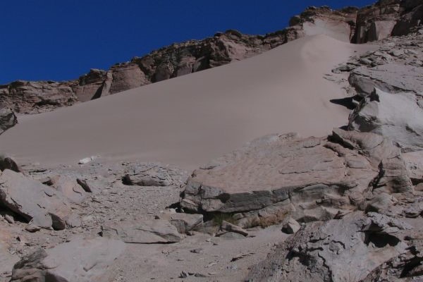
We take a van up to the Catarpe Valley, where we begin ascending the Salt Mountain Range. On the way, we’ll see petroglyphs and from the top, we can admire the green valley landscapes contrasting with the colors of Salt and Andes Mountain Ranges. This is an ideal introduction to the Atacama region. We return by van.
*Temporarily unavailable. Consult other exploration options with your Explora guide at the destination.
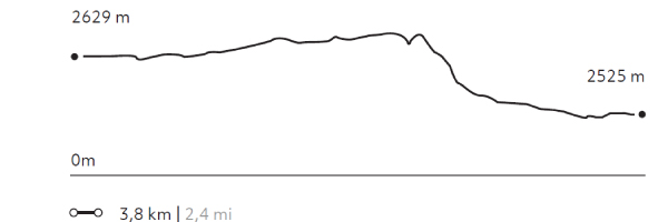
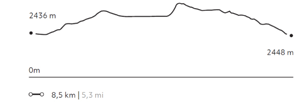
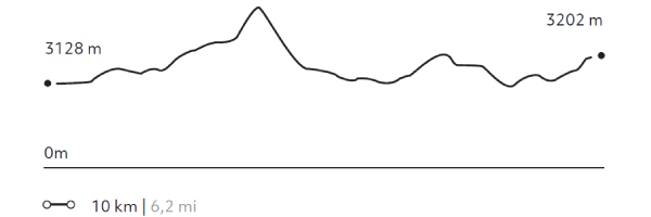
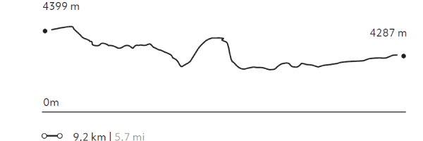
283 m 928 ft
-292 m -958 ft
2.693 m 8.833 ft
2.550 m 8.364 ftElevation Profile
Kari
Cuenca del salar
-
Hike
-
Easy
-
Half-day
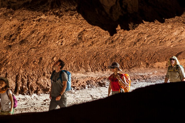
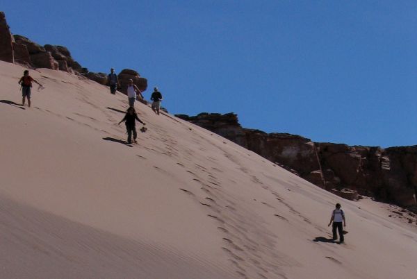
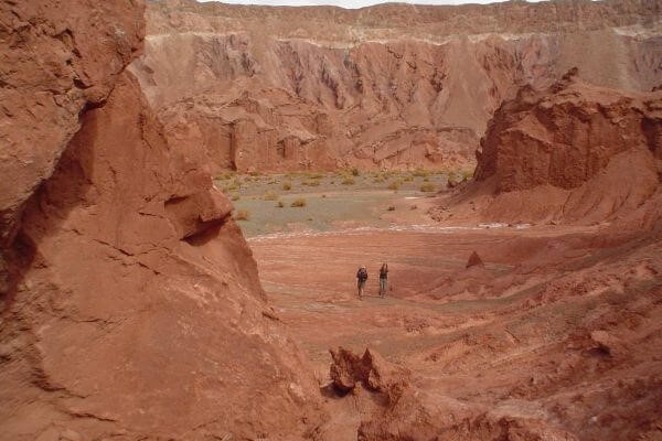
We take a van to the Salt Mountain Range. We begin our walk at a viewpoint with panoramic views to the Moon Valley...
More details >Kari

-
Exploration Path
We take a van to the Salt Mountain Range. We begin our walk at a viewpoint with panoramic views to the Moon Valley. We go down a dune and walk along Kari creek, a canyon carved by the erosion of water and surrounded by sedimentary walls of clay, plaster, and salt. We return by van.
*Temporarily unavailable. Consult other exploration options with your Explora guide at the destination.
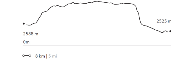
160 m 525 ft
-339 m -1112 ft
2.610 m 8.561 ft
2.423 m 7.947 ftElevation Profile
Puricamar
Cuenca del salar
-
Hike
-
Easy
-
Half-day
We take a van to the Moon Valley. Once there, we begin walking throughout this reserve, among moon-like landscapes with rock formations...
More details >Puricamar
-
Exploration Path
We take a van to the Moon Valley. Once there, we begin walking throughout this reserve, among moon-like landscapes with rock formations, natural sculptures and huge sand dunes. We end up with a 360° view of the desert. We return by van.
*Temporarily unavailable. Consult other exploration options with your Explora guide at the destination.
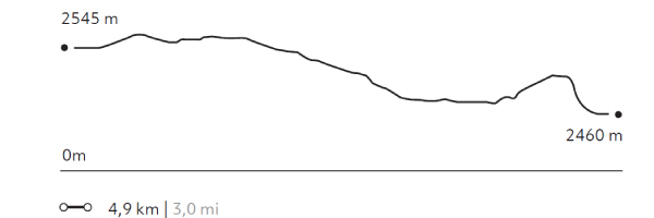
99 m 325 ft
-184 m -604 ft
2.579 m 8.459 ft
2.460 m 8.069 ftElevation Profile
Kezar
Quebradas Intermedias
-
Hike
-
Easy
-
Half-day
We start our exploration at the Puritama River creek. We descend to walk along the creek following the river bed between large rock walls...
More details >Kezar
-
Exploration Path
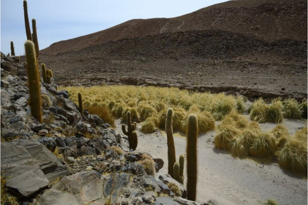
We start our exploration at the Puritama River creek. We descend to walk along the creek following the river bed between large rock walls, shrubs and cacti over an irregular terrain. At the end, we arrive at the Puritama Hot Springs to enjoy the amazing properties of these thermal waters.
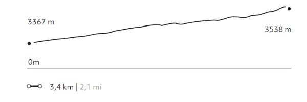
231 m 758 ft
-60 m -198 ft
3.538 m 11.605 ft
3.365 m 11.037 ftElevation Profile
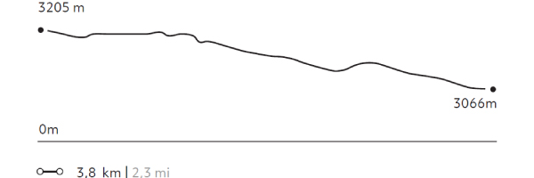
Punta del Inca
Quebradas Intermedias
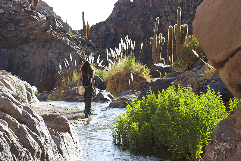
-
Hike
-
Moderate
-
Half-day
We take a van to Guatín, a grazing area and junction point of the Puritama and Purifica rivers, and source of the Vilama River...
More details >Punta del Inca
-
Exploration Path
We take a van to Guatín, a grazing area and junction point of the Puritama and Purifica rivers, and source of the Vilama River. There, we walk along a canyon known as the Valley of the Cacti due to the existence of giant cacti. We cut cross the canyon crossing the river several times and descending along different waterfalls.
84 m 275 ft
-223 m -731 ft
3.205 m 10.512 ft
3.066 m 10.056 ftElevation Profile
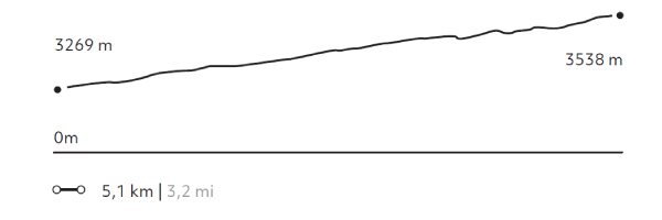
Puritama
Quebradas Intermedias
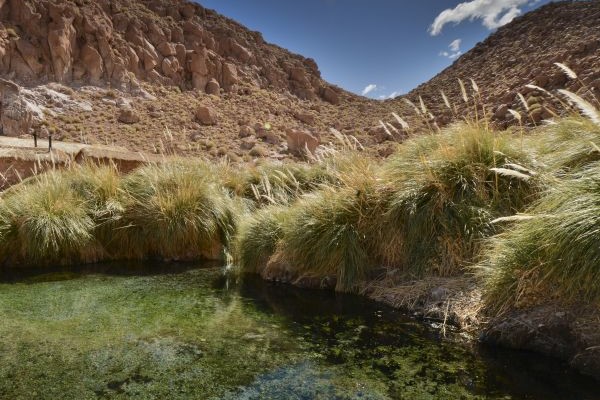
-
Hike
-
Moderate
-
Half-day
We take a van to Guatín where we begin an ascending walk. We walk for almost 30 minutes along giant cacti up to the Puritama River creek...
More details >Puritama
-
Exploration Path
We take a van to Guatín where we begin an ascending walk. We walk for almost 30 minutes along giant cacti up to the Puritama River creek. There, we descend to walk along the river, through rock walls and vegetation. We arrive to the Puritama Hot Springs were we will have some time to relax.
327 m 1073 ft
-58 m -192 ft
3.538 m 11.605 ft
3.269 m 10.722 ftElevation Profile
Huayra
Cuenca del salar
-
Hike
-
Easy
-
Half-day
We take a van to the Mars Valley in the Salt Mountain Range, where we begin a walk with views to the different mountain ranges...
More details >Huayra
-
Exploration Path
We take a van to the Mars Valley in the Salt Mountain Range, where we begin a walk with views to the different mountain ranges in the region and felling the wind of the area. We descend through sand dunes and continue walking across the valley, where the van will be waiting to take us back.
*Temporarily unavailable. Consult other exploration options with your Explora guide at the destination.
145 m 476 ft
-249 m -817 ft
2.710 m 8.889 ft
2.614 m 8.574 ftElevation Profile
Cornisas
Cuenca del salar
-
Hike
-
Moderate
-
Half-day
We take a van to the Catarpe Valley, where we will walk along the edges of the Salt Mountain Range, with views to the oasis...
More details >Cornisas
-
Exploration Path
We take a van to the Catarpe Valley, where we will walk along the edges of the Salt Mountain Range, with views to the oasis, the salt field and the mountain ranges that define the geography of this destination. We then cross different dunes of the Mars Valley and return by van.
*Temporarily unavailable. Consult other exploration options with your Explora guide at the destination.
224 m 735 ft
-279 m -915 ft
2.710 m 8.889 ft
2.514 m 8.246 ftElevation Profile
Kamur
Cuenca del salar
-
Hike
-
Moderate
-
Half-day
We take a van to the Moon Valley to appreciate the different landscapes of the Salt Mountain Range, where erosion by water...
More details >Kamur
-
Exploration Path
We take a van to the Moon Valley to appreciate the different landscapes of the Salt Mountain Range, where erosion by water and wind has originated dunes and unique geological formations that can only be seen here. This hike, from west to east, goes through a path that is not frequently used.
*Temporarily unavailable. Consult other exploration options with your Explora guide at the destination.
197 m 646 ft
-185 m -607 ft
2.564 m 8.410 ft
2.432 m 7.977 ftElevation Profile
Matancilla
Quebradas Intermedias
-
Hike
-
Easy
-
Half-day
We take a van to the Domeyko Mountain Range where we walk following a creek that used to be a route for gathering and bartering caravans...
More details >Matancilla
-
Exploration Path
We take a van to the Domeyko Mountain Range where we walk following a creek that used to be a route for gathering and bartering caravans. The walk ends at the Rainbow Valley formed by huge multicolored walls of mineral-rich soils. We return by van.
204 m 669 ft
-263 m -863 ft
3.231 m 10.598 ft
3.134 m 10.280 ftElevation Profile
Wanaku
Quebradas Intermedias
-
Hike
-
Moderate
-
Full-day
We take a van to the Domeyko Mountain Range, where we walk through trails that were formerly used as transit and bartering routes...
More details >Wanaku
-
Exploration Path
We take a van to the Domeyko Mountain Range, where we walk through trails that were formerly used as transit and bartering routes and where we can still see remains of the Atacameño culture. We continue to the Rainbow Valley, a place with huge multicolored walls that explain the geological shaping of the Atacama region.
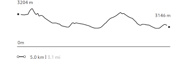
410 m 1345 ft
-336 m -1102 ft
3.292 m 10.798 ft
3.198 m 10.489 ftElevation Profile
Incahuasi
Quebradas Intermedias
-
Hike
-
Advanced
-
Full-day
We start walking in an old farmhouse at the foot of the volcanoes of the Andes mountain range. We will enter the Jorquencal gorge...
More details >Incahuasi

-
Exploration Path
We start walking in an old farmhouse at the foot of the volcanoes of the Andes mountain range. We will enter the Jorquencal gorge where we will explore the varied vegetation, history and study of the Andean cat in the Puritama reserve. After crossing a varied landscape we will arrive at the Puritama hot springs, to rest there. Return by van to Explora.
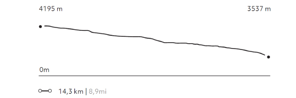
181 m 594 ft
-832 m -2729 ft
4.195 m 13.760 ft
3.537 m 11.601 ftElevation Profile
Rio Blanco
Altiplano
-
Hike
-
Advanced
-
Full-day
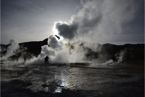
We take a van to the Tatio Geysers, where we first walk up and then down a creek to reach an unknown warm water river, the Blanco River...
More details >Rio Blanco
-
Exploration Path
We take a van to the Tatio Geysers, where we first walk up and then down a creek to reach an unknown warm water river, the Blanco River. We walk along the river’s bed near geysers and mineral formations unique to this geological landscape.
31 m 101 ft
-421 m -1381 ft
4.408 m 14.458 ft
4.226 m 13.861 ftElevation Profile
Peñaliri
Quebradas Intermedias
-
Hike
-
Moderate
-
Full-day
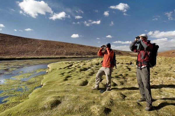
We take a van to Machuca, an Andean Plateau village. We begin exploring a wetland and then walk along a creek to the Grande River...
More details >Peñaliri
-
Exploration Path
We take a van to Machuca, an Andean Plateau village. We begin exploring a wetland and then walk along a creek to the Grande River. In this exploration we can see fauna and typical Andean farming terraces. We have lunch at Peñaliri, an abandoned village.
*Temporarily unavailable. Consult other exploration options with your Explora guide at the destination.
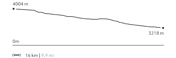
273 m 895 ft
-1056 m -3464 ft
4.012 m 13.159 ft
3.218 m 10.555 ftElevation Profile
-
Other options: