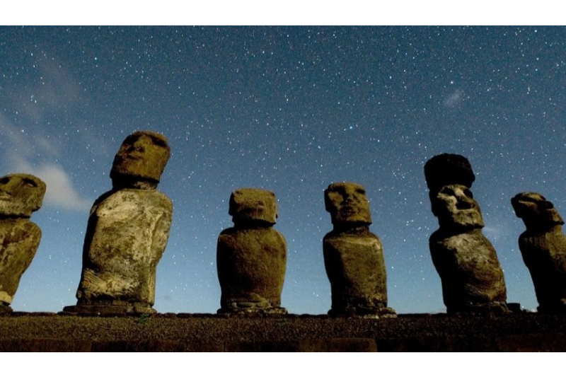
Easter Island
Easter Island, Chile
Explorations in
Easter Island
Activity
Difficulty
Areas
Bird cult
Rano Kau
-
 Overland
 -
Easy
-
Half-day
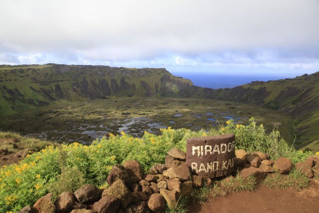
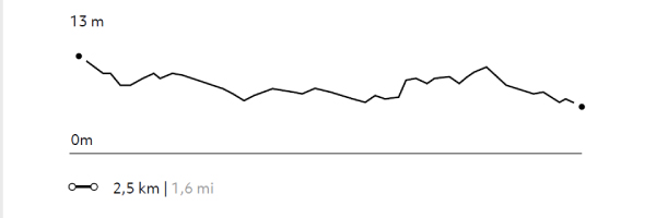
Departure by van to Vinapu to visit its Ahu and its unique construction. Afterwards, we head by van to Rano Kau, the island’s largest crater...
More details >Bird cult


-
Exploration Path
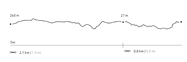
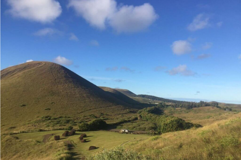
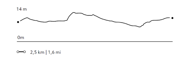
Departure by van to Vinapu to visit its Ahu and its unique construction. Afterwards, we head by van to Rano Kau, the island’s largest crater. We hike around part of the crater where we watch the biodiversity of the wetland within it and continue to the ceremonial town of Orongo, known for the Birdman competition. Subsequently, we visit the Mateveri area with its unique volcanic landscapes and its relationship with Orongo.
159 m 522 ft
-146 m -479 ft
294 m 965 ft
213 m 699 ftElevation Profile
Rapa Nui Sanctuaries
Lava Flows
-
Overland
-
Easy
-
Half-day
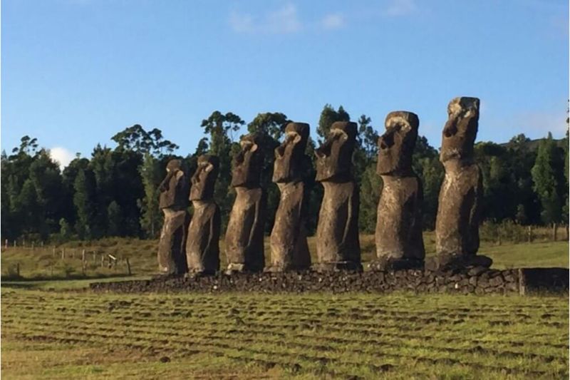
We visit Akivi with the Ahu of the 7 moai facing the sea. We walk the Roiho lava field, where we visit a lava tunnel, the Ana Te Pahu cave...
More details >Rapa Nui Sanctuaries
-
Exploration Path
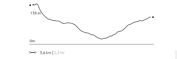
We visit Akivi with the Ahu of the 7 moai facing the sea. We walk the Roiho lava field, where we visit a lava tunnel, the Ana Te Pahu cave. We continue by van to visit the Ahu Huri A Urenga, a platform located in the interior of the island that is aligned with the sunrise on the winter solstice. We return by van.
38 m 123 ft
-56 m -182 ft
138 m 453 ft
89 m 292 ftElevation Profile
Hanga
Miru
-
Overland
-
Easy
-
Half-day
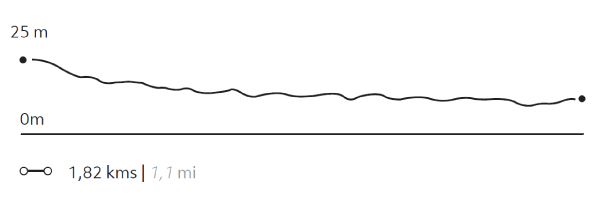
We take a van to Papa Vaka, an archaeological site with petroglyphs. We hike and go by a cove and continue hiking up to Tepito Kura...
More details >Hanga
-
Exploration Path
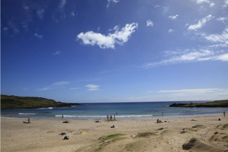
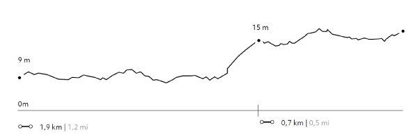
We take a van to Papa Vaka, an archaeological site with petroglyphs. We hike (1) and go by a cove and continue hiking up to Tepito Kura, a site featuring a huge tumbled moai and a magnetic stone associated to Rapa Nui’s origins. We continue by van to Anakena, the landing area of the first Polynesian settlers (2). Time to enjoy the beach. Bring your swimsuit.
34 m 112 ft
-17 m -55 ft
26 m 85 ft
4 m 13 ftElevation Profile
Pukao
The South
-
Overland
-
Easy
-
Half-day
In this exploration we see the traces of the path of the Pukao (“top knot” in Rapa Nui) towards the moai...
More details >Pukao
-
Exploration Path
In this exploration we see the traces of the path of the Pukao (“top knot” in Rapa Nui) towards the moai. We start in Puna Pau, the quarry of the Pukao, we continue by van to the South coast to visit Hanga Poukura, the largest non-restored platform or Ahu on the island and Hanga Te'e with an interpretive center where we walk to learn more about the history and the landscape of a less explored area of Rapa Nui. Return by van.
23 m 75 ft
-25 m -83 ft
16 m 52 ft
3 m 10 ftElevation Profile
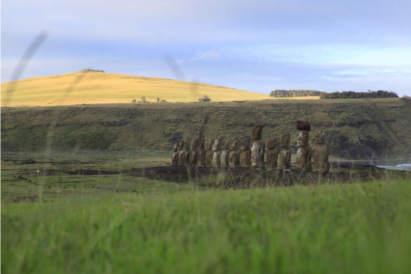
Tongariki
Hotu Iti
-
Overland
-
Easy
-
Half-day
We take a van to Ahu One Makihi with its huge tumbled moai. We continue to Tongariki to learn the history of Rapa Nui’s largest Ahu...
More details >Tongariki
-
Exploration Path
We take a van to Ahu One Makihi with its huge tumbled moai. We continue to Tongariki to learn the history of Rapa Nui’s largest Ahu and we explore its surroundings, after which we understand the division between east and west in Rapa Nui.
26 m 86 ft
-35 m -113 ft
18 m 59 ft
4 m 13 ftElevation Profile
Cook´s Bay
Rano Kau
-
Overland
-
Easy
-
Half-day
We go by van to the Hanga Kioe archaeological site, where the Ahu Akapu is located on the west coast near the town of Hanga Roa...
More details >Cook´s Bay
-
Exploration Path
We go by van to the Hanga Kioe archaeological site, where the Ahu Akapu is located on the west coast near the town of Hanga Roa. We continue by van to the anthropological museum to visit it. We continue walking from the museum along the coast to the village cove, passing through the Tahai archaeological complex and other attractive historical sites.
14,7 m 48 ft
-33,9 m -111 ft
25 m 82 ft
3 m 10 ftElevation Profile
-
Other options: