Atacama
Desert & Altiplano, Chile
Explorations in
Atacama
Activity
Difficulty
Areas
3 Cordilleras
Cuenca del salar
-
 Horseback Ride
 -
Advanced
-
Half-day
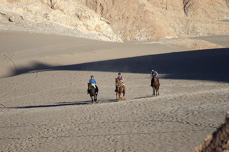
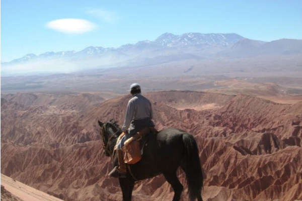
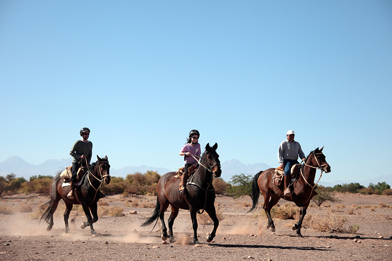
We horseback ride to the Catarpe Valley through a road immersed in the oasis, where we will be able to trot and gallop before climbing up...
More details >3 Cordilleras


-
Exploration Path
We horseback ride to the Catarpe Valley through a road immersed in the oasis, where we will be able to trot and gallop before climbing up a ledge in the Salt Mountain Range. On our return to Explora, we ride around the ledge with panoramic views of the three mountain ranges and descend through dunes to the Mars Valley.
For experienced and advanced riders only. This exploration is only available for advanced riders who have mastered rising trot and canter over uneven terrain in open spaces and on all types of horses. A test in the hotel is required before going out into the desert.
*Temporarily unavailable. Consult other exploration options with your Explora guide at the destination.
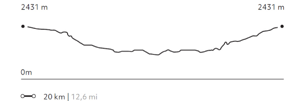
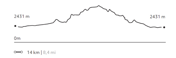
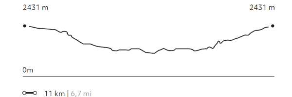
424 m 1391 ft
-424 m -1391 ft
2.709 m 8.886 ft
2.431 m 7.974 ftElevation Profile
Beter
Cuenca del salar
-
Horseback Ride
-
Advanced
-
Half-day
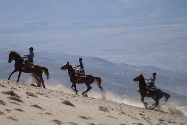
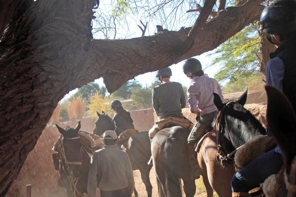
In this exploration, we visit the two ayllus, ancient Atacameño farm communities, where we can see the local lifestyle...
More details >Beter
-
Exploration Path
In this exploration, we visit the two ayllus, ancient Atacameño farm communities, where we can see the local lifestyle, vegetable gardens and archeological remains. To begin, we will go to the ayllu in Solor. Next we continue to the ayllu dunes of Beter, one of the first Atacameño settlement.
For experienced and advanced riders only. This exploration is only available for advanced riders who have mastered rising trot and canter over uneven terrain in open spaces and on all types of horses. A test in the hotel is required before going out into the desert.
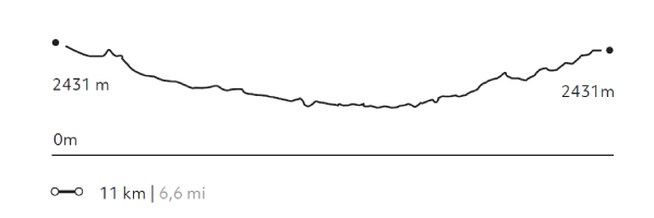
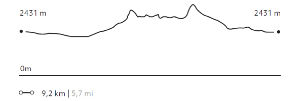
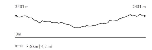
106 m 348 ft
-106 m -348 ft
2.431 m 7.974 ft
2.388 m 7.833 ftElevation Profile
Valle de Marte
Cuenca del salar
-
Horseback Ride
-
Advanced
-
Half-day
We leave the hotel to go to the Mars Valley, where we horseback ride among typical desert landscapes: dunes...
More details >Valle de Marte
-
Exploration Path
We leave the hotel to go to the Mars Valley, where we horseback ride among typical desert landscapes: dunes, reddish sedimentary rock formations and clay grounds. This exploration is perfect to get an idea of the geography and origin of the Salt Ridge.
For experienced and advanced riders only. This exploration is only available for advanced riders who have mastered rising trot and canter over uneven terrain in open spaces and on all types of horses. A test in the hotel is required before going out into the desert.
*Temporarily unavailable. Consult other exploration options with your Explora guide at the destination.
241 m 790 ft
-241 m -790 ft
2.556 m 8.384 ft
2.428 m 7.964 ftElevation Profile
Dunas de la Chula
Cuenca del salar
-
Horseback Ride
-
Easy
-
Half-day
We horseback ride to the Salt Mountain Range. We go across the San Pedro River and sand dunes, from where we have panoramic views...
More details >Dunas de la Chula

-
Exploration Path
We horseback ride to the Salt Mountain Range. We go across the San Pedro River and sand dunes, from where we have panoramic views of the Andes Mountain Range and the oasis. Afterwards, we follow through a dry riverbed and comeback to Explora through the pampa.
114 m 374 ft
-114 m -374 ft
2.481 m 8.138 ft
2.410 m 7.905 ftElevation Profile
Solor
Cuenca del salar
-
Horseback Ride
-
Easy
-
Half-day
We travel to the ayllu in Solor, located to the south of San Pedro. Here we can see one of the oasis’s most developed farming areas...
More details >Solor
-
Exploration Path
We travel to the ayllu in Solor, located to the south of San Pedro. Here we can see one of the oasis’s most developed farming areas. On our way, we can see typical desert constructions –using adobe and straw roofs– and we go across a small irrigation canal. Before we return, we visit the mythical Librería del desierto.
64 m 211 ft
-64 m -211 ft
2.431 m 7.974 ft
2.400 m 7.872 ftElevation Profile
Séquitor
Cuenca del salar
-
Horseback Ride
-
Easy
-
Half-day
We horseback ride to the ayllus located in Séquitor, Yaye, and Checar, Atacameño social and farming communities that are also...
More details >Séquitor
-
Exploration Path
We horseback ride to the ayllus located in Séquitor, Yaye, and Checar, Atacameño social and farming communities that are also considered small oasis in the middle of the desert. Here, vegetable gardens still prevail and the Atacama construction technique using adobe and straw roofs is still seen.
42 m 137,4 ft
-42 m -137 ft
2.431 m 7.974 ft
2.410 m 7.905 ftElevation Profile
Kamur
Cuenca del salar
-
Hike
-
Moderate
-
Half-day
We take a van to the Moon Valley to appreciate the different landscapes of the Salt Mountain Range, where erosion by water...
More details >Kamur


-
Exploration Path
We take a van to the Moon Valley to appreciate the different landscapes of the Salt Mountain Range, where erosion by water and wind has originated dunes and unique geological formations that can only be seen here. This hike, from west to east, goes through a path that is not frequently used.
*Temporarily unavailable. Consult other exploration options with your Explora guide at the destination.
197 m 646 ft
-185 m -607 ft
2.564 m 8.410 ft
2.432 m 7.977 ftElevation Profile
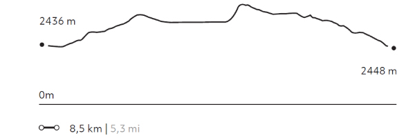
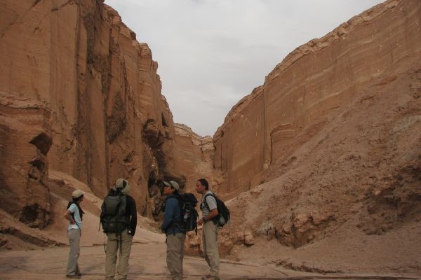
Cornisas
Cuenca del salar
-
Hike
-
Moderate
-
Half-day
We take a van to the Catarpe Valley, where we will walk along the edges of the Salt Mountain Range, with views to the oasis...
More details >Cornisas
-
Exploration Path
We take a van to the Catarpe Valley, where we will walk along the edges of the Salt Mountain Range, with views to the oasis, the salt field and the mountain ranges that define the geography of this destination. We then cross different dunes of the Mars Valley and return by van.
*Temporarily unavailable. Consult other exploration options with your Explora guide at the destination.
224 m 735 ft
-279 m -915 ft
2.710 m 8.889 ft
2.514 m 8.246 ftElevation Profile
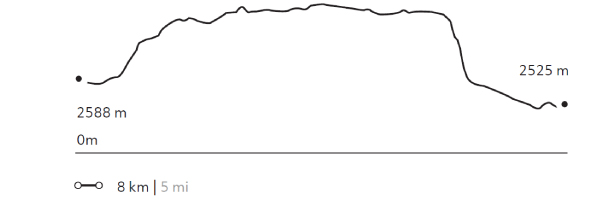
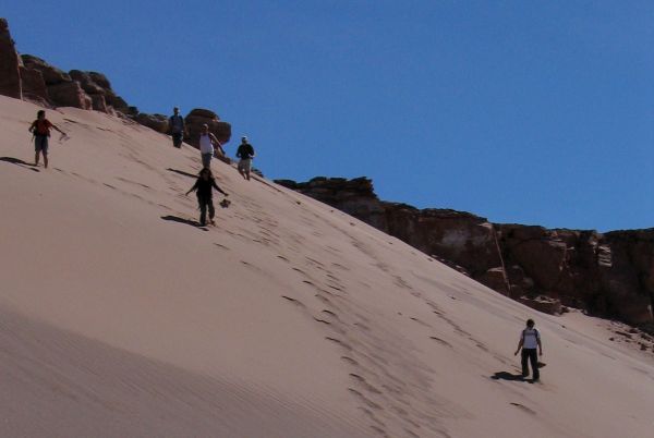
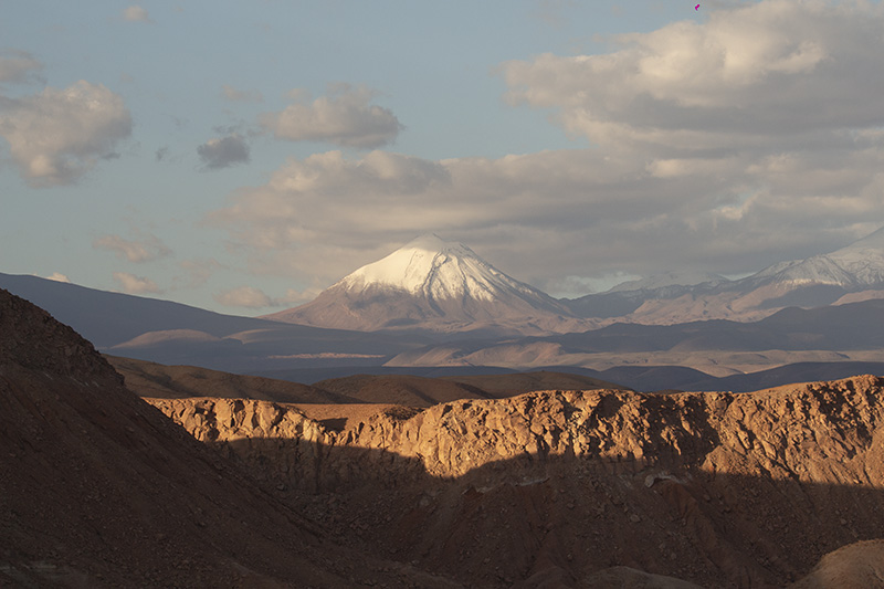
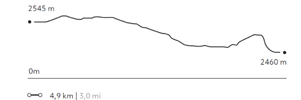
Huayra
Cuenca del salar
-
Hike
-
Easy
-
Half-day
We take a van to the Mars Valley in the Salt Mountain Range, where we begin a walk with views to the different mountain ranges...
More details >Huayra
-
Exploration Path
We take a van to the Mars Valley in the Salt Mountain Range, where we begin a walk with views to the different mountain ranges in the region and felling the wind of the area. We descend through sand dunes and continue walking across the valley, where the van will be waiting to take us back.
*Temporarily unavailable. Consult other exploration options with your Explora guide at the destination.
145 m 476 ft
-249 m -817 ft
2.710 m 8.889 ft
2.614 m 8.574 ftElevation Profile
Puricamar
Cuenca del salar
-
Hike
-
Easy
-
Half-day
We take a van to the Moon Valley. Once there, we begin walking throughout this reserve, among moon-like landscapes with rock formations...
More details >Puricamar
-
Exploration Path
We take a van to the Moon Valley. Once there, we begin walking throughout this reserve, among moon-like landscapes with rock formations, natural sculptures and huge sand dunes. We end up with a 360° view of the desert. We return by van.
*Temporarily unavailable. Consult other exploration options with your Explora guide at the destination.
99 m 325 ft
-184 m -604 ft
2.579 m 8.459 ft
2.460 m 8.069 ftElevation Profile
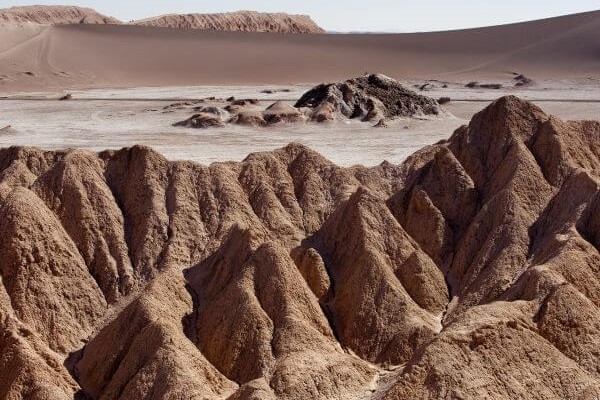
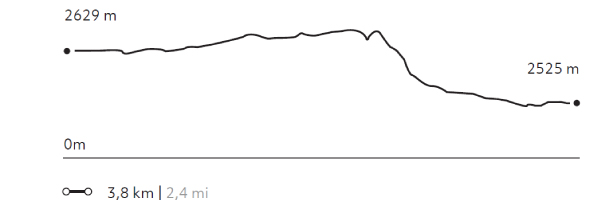
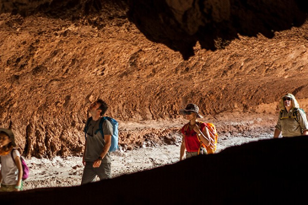
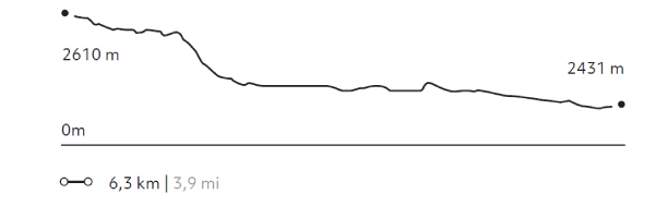
Kari
Cuenca del salar
-
Hike
-
Easy
-
Half-day
We take a van to the Salt Mountain Range. We begin our walk at a viewpoint with panoramic views to the Moon Valley...
More details >Kari
-
Exploration Path
We take a van to the Salt Mountain Range. We begin our walk at a viewpoint with panoramic views to the Moon Valley. We go down a dune and walk along Kari creek, a canyon carved by the erosion of water and surrounded by sedimentary walls of clay, plaster, and salt. We return by van.
*Temporarily unavailable. Consult other exploration options with your Explora guide at the destination.
160 m 525 ft
-339 m -1112 ft
2.610 m 8.561 ft
2.423 m 7.947 ftElevation Profile
-
Other options: