Atacama
Desert & Altiplano, Chile
Explorations in
Atacama
Activity
Difficulty
Areas
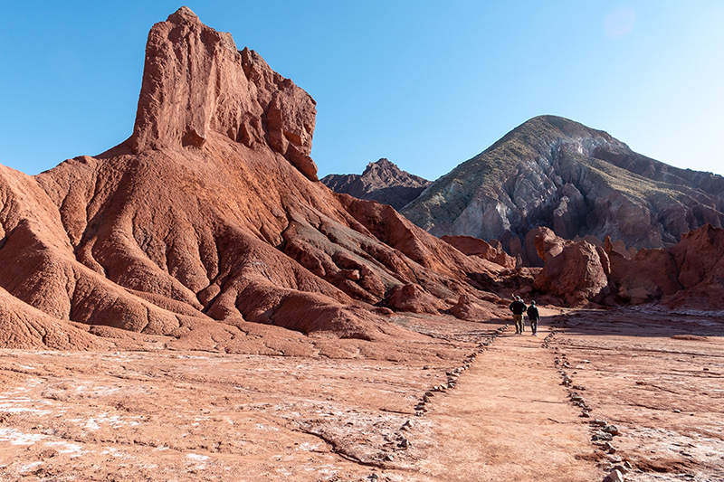
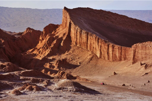
Arcoiris
Quebradas Intermedias
-
 Bike
Bike -
Moderate
-
Half-day
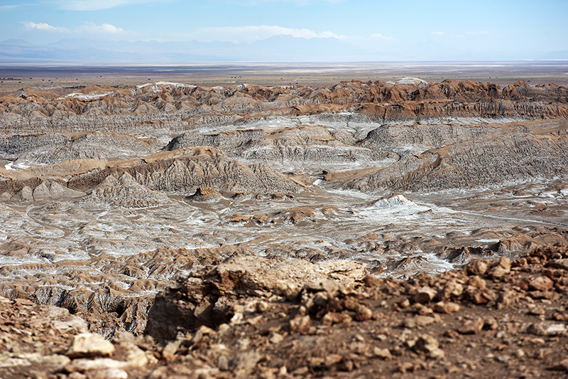
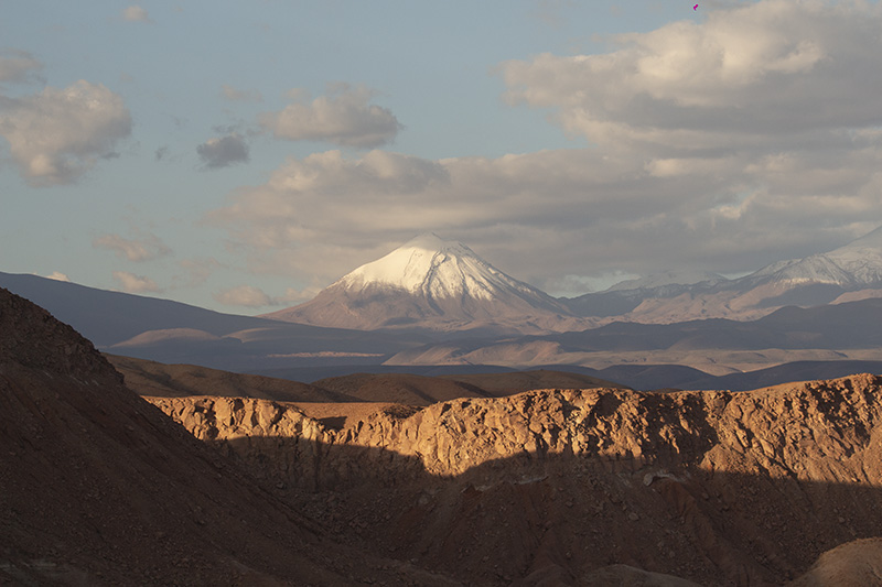
We take a van to the Domeyko Mountain Range (one hour travel), where we will pedal through a path to the valley creek between multicolored...
More details >Arcoiris


-
Exploration Path
We take a van to the Domeyko Mountain Range (one hour travel), where we will pedal through a path to the valley creek between multicolored walls. Guanacos, other typical fauna and the varied flora of the area can be seen during this exploration. We return by van.
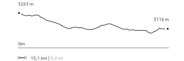
249 m 816,7 ft
-396 m -1299 ft
3.269 m 10.722 ft
3.067 m 10.060 ftElevation Profile
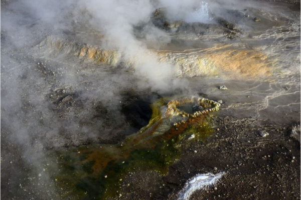
Reserva Tatio
Altiplano
-
Overland
-
Easy
-
Half-day
We take a van to the Tatio Geysers. Along the way, an important part of the Andean Plateau fauna –including vicuñas, flamingos, foxes...
More details >Reserva Tatio


-
Exploration Path
We take a van to the Tatio Geysers. Along the way, an important part of the Andean Plateau fauna –including vicuñas, flamingos, foxes, and others– can be appreciated. We walk across the reserve feeling the inner activities of the land with views to the Andes Mountain Range and the hot water springs from where steam rises. We return by van.
Kunza
Cuenca del salar
-
Overland
-
Easy
-
Half-day
In this exploration we learn about the Atacameño history and culture. We start with a guided tour of an archaeological deposit...
More details >Kunza
-
Exploration Path
In this exploration we learn about the Atacameño history and culture. We start with a guided tour of an archaeological deposit where we can see ceramic pieces and other historical artifacts fit for a museum. Later on, we move on to the village of Tulor, one of the first settlements. We end the exploration at the mythical desert bookstore.
Cardones
Quebradas Intermedias
-
Overland
-
Easy
-
Half-day
We go by van to the town of Guatin, where we will walk through the beginning of the Vilama canyon, with various species of cactaceae...
More details >Cardones
-
Exploration Path
We go by van to the town of Guatin, where we will walk through the beginning of the Vilama canyon, with various species of cactaceae, flora and fauna of this area. We continue by van to the Puritama Reserve.
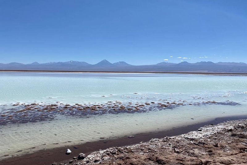
Tebenquinche
Cuenca del salar
-
Overland
-
Easy
-
Half-day
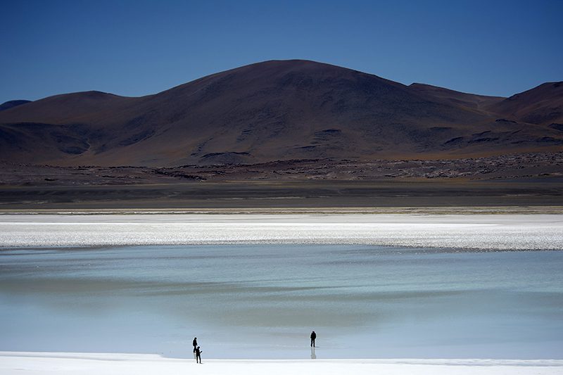
Departure from Explora by van to the northern part of the Salar de Atacama arriving at the Tebenquinche lagoon, habitat for various birds...
More details >Tebenquinche
-
Exploration Path
Departure from Explora by van to the northern part of the Salar de Atacama arriving at the Tebenquinche lagoon, habitat for various birds in the area. We can walk along the lagoons to learn more about these special formations with views of the Andes. We will continue by van to Céjar, the salty lagoon where we can bathe and float.
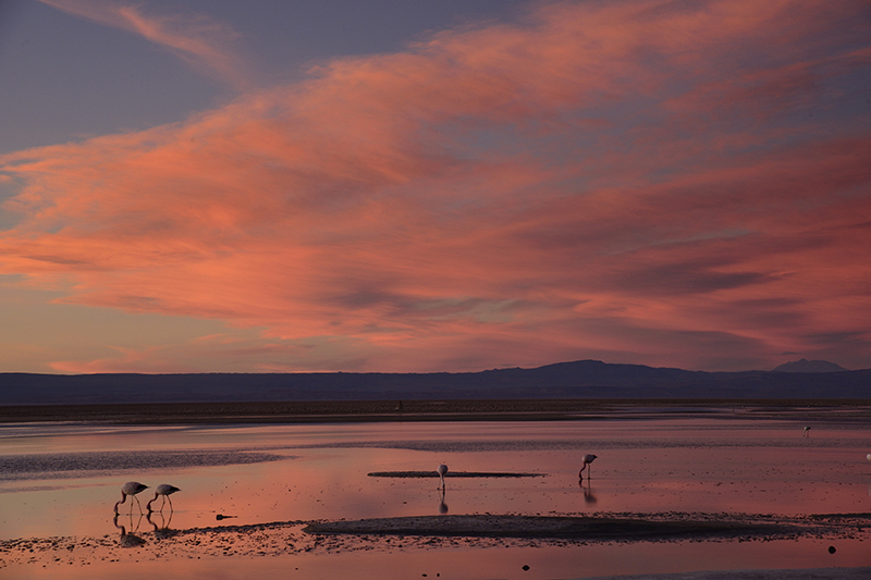
Gran Salar
Cuenca del salar
-
Overland
-
Easy
-
Half-day
We leave in a van to Toconao, located to the south of San Pedro de Atacama. We walk to the village square and then through an area...
More details >Gran Salar
-
Exploration Path
We leave in a van to Toconao, located to the south of San Pedro de Atacama. We walk to the village square and then through an area of vegetable gardens. We finally take a van to the Chaxa Lagoon, located in the Los Flamencos National Reserve, an ideal place for bird watching within Atacama’s Salt Flat.
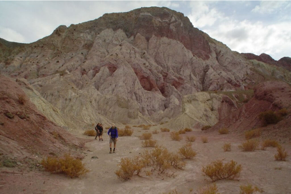
Quebradas
Quebradas Intermedias
-
Overland
-
Easy
-
Half-day
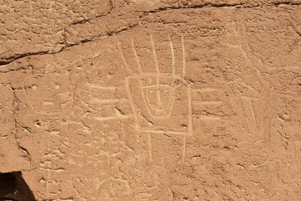
We take a van to the Yerbas Buenas archaeological site located in the Domeyko Mountain Range. Here we can see...
More details >Quebradas
-
Exploration Path
We take a van to the Yerbas Buenas archaeological site located in the Domeyko Mountain Range. Here we can see different styles of petroglyphs.
We continue to the Rainbow Valley, where a special formation with varied shades of colors welcomes us to walk through the valley.
Cordillera de la Sal
Cuenca del salar
-
Overland
-
Easy
-
Half-day
We take a van to the Salt Mountain Range to see typical desert landscapes: open reddish clay grounds, sand dunes...
More details >Cordillera de la Sal
-
Exploration Path
We take a van to the Salt Mountain Range to see typical desert landscapes: open reddish clay grounds, sand dunes, and sedimentary rock formations. We walk up to the highest point of this mountain range to see the panoramic views. We will take a 30 minute walk through one the least known mountainsides of the Salt Ridge.
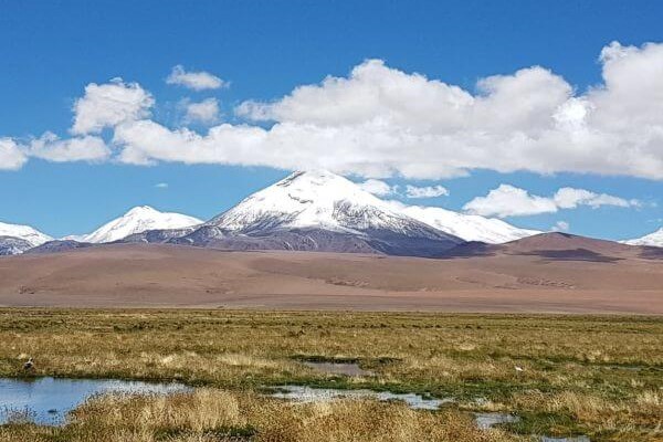
Altiplano
Altiplano
-
Overland
-
Easy
-
Full-day
We leave in a van and travel to the borderline with Argentina to appreciate multicolored landscapes and the Andean Plateau Salt Flats....
More details >Altiplano
-
Exploration Path
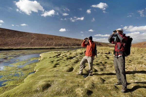
We leave in a van and travel to the borderline with Argentina to appreciate multicolored landscapes and the Andean Plateau Salt Flats. We explore different ecological floors, which allow us to see the diversity in flora and fauna. We come down from the van to feel what is like to walk over 4,000 m.a.s.l (13,123 f.a.s.l).
Nómade
Altiplano
-
Overland
-
Easy
-
Full-day
We take a van to Talabre, where we visit the archaeological site of Kezala with petroglyphs as old as 800 - 400 B.C. We continue our journey...
More details >Nómade
-
Exploration Path
We take a van to Talabre, where we visit the archaeological site of Kezala with petroglyphs as old as 800 - 400 B.C. We continue our journey through solitary pathways into the heart of the mountain range in the Andes Plateau. We have lunch in the middle of a natural environment and then come back to Explora.
Lagunas
Altiplano
-
Overland
-
Easy
-
Full-day
Departure of Explora by van to the central area of the Atacama Saltflat reaching the Laguna Chaxa, habitat for various birds in the area....
More details >Lagunas
-
Exploration Path
Departure of Explora by van to the central area of the Atacama Saltflat reaching the Laguna Chaxa, habitat for various birds in the area. We can walk along a path immersed in the Salar de Atacama. We will continue by van towards the altiplano, visiting lagoons and natural scenes of the Altiplano on the Andes, where a special habitat is generated for different species of birds and fauna. We will have lunch and then return to Explora.
Peñaliri
Quebradas Intermedias
-
Hike
-
Moderate
-
Full-day
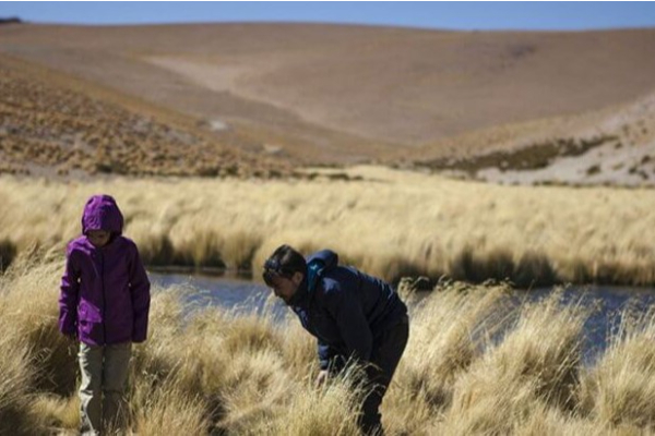
We take a van to Machuca, an Andean Plateau village. We begin exploring a wetland and then walk along a creek to the Grande River...
More details >Peñaliri

-
Exploration Path
We take a van to Machuca, an Andean Plateau village. We begin exploring a wetland and then walk along a creek to the Grande River. In this exploration we can see fauna and typical Andean farming terraces. We have lunch at Peñaliri, an abandoned village.
*Temporarily unavailable. Consult other exploration options with your Explora guide at the destination.
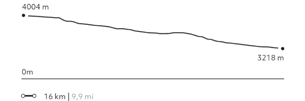
273 m 895 ft
-1056 m -3464 ft
4.012 m 13.159 ft
3.218 m 10.555 ftElevation Profile
Kari
Cuenca del salar
-
Hike
-
Easy
-
Half-day
We take a van to the Salt Mountain Range. We begin our walk at a viewpoint with panoramic views to the Moon Valley...
More details >Kari
-
Exploration Path
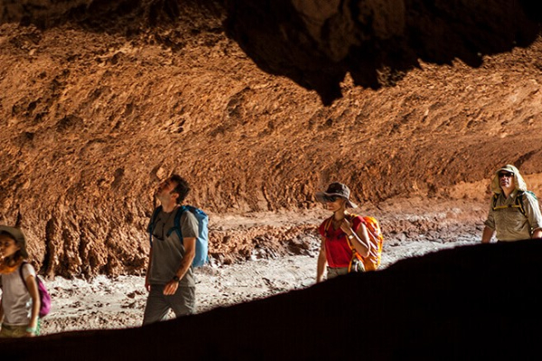
We take a van to the Salt Mountain Range. We begin our walk at a viewpoint with panoramic views to the Moon Valley. We go down a dune and walk along Kari creek, a canyon carved by the erosion of water and surrounded by sedimentary walls of clay, plaster, and salt. We return by van.
*Temporarily unavailable. Consult other exploration options with your Explora guide at the destination.
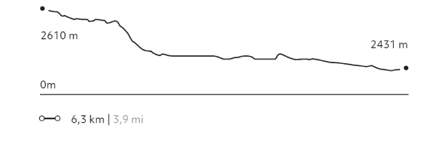
160 m 525 ft
-339 m -1112 ft
2.610 m 8.561 ft
2.423 m 7.947 ftElevation Profile
Puricamar
Cuenca del salar
-
Hike
-
Easy
-
Half-day
We take a van to the Moon Valley. Once there, we begin walking throughout this reserve, among moon-like landscapes with rock formations...
More details >Puricamar
-
Exploration Path
We take a van to the Moon Valley. Once there, we begin walking throughout this reserve, among moon-like landscapes with rock formations, natural sculptures and huge sand dunes. We end up with a 360° view of the desert. We return by van.
*Temporarily unavailable. Consult other exploration options with your Explora guide at the destination.
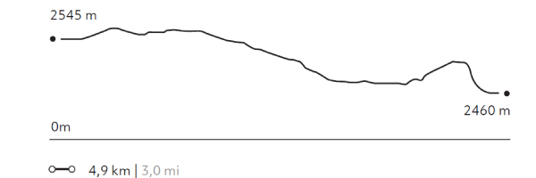
99 m 325 ft
-184 m -604 ft
2.579 m 8.459 ft
2.460 m 8.069 ftElevation Profile
Kezar
Quebradas Intermedias
-
Hike
-
Easy
-
Half-day
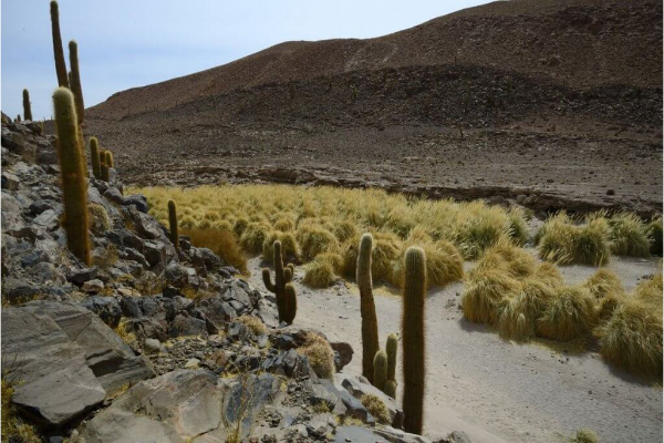
We start our exploration at the Puritama River creek. We descend to walk along the creek following the river bed between large rock walls...
More details >Kezar
-
Exploration Path
We start our exploration at the Puritama River creek. We descend to walk along the creek following the river bed between large rock walls, shrubs and cacti over an irregular terrain. At the end, we arrive at the Puritama Hot Springs to enjoy the amazing properties of these thermal waters.
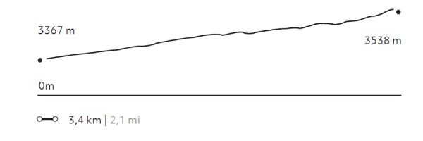
231 m 758 ft
-60 m -198 ft
3.538 m 11.605 ft
3.365 m 11.037 ftElevation Profile
-
Other options: