Atacama
Desert & Altiplano, Chile
Explorations in
Atacama
Activity
Difficulty
Areas
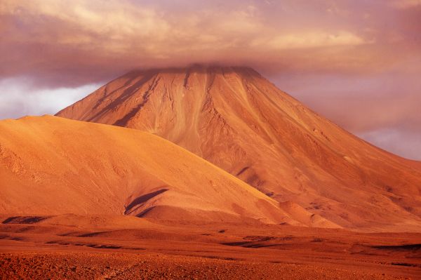
Sairecabur
Montaña
-
 High Mountain Ascent
 -
Expert
-
Full-day
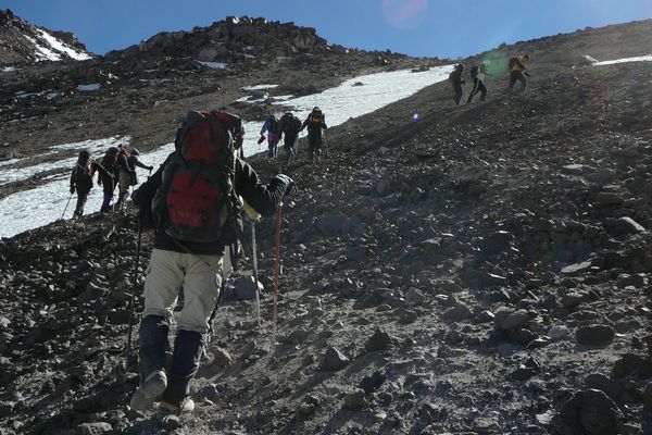
After a one-and-a-half hour drive by van, we reach the Sairecabur Volcano’s caldera, where we begin ascending. We walk through rocks...
More details >Sairecabur


-
Exploration Path
After a one-and-a-half hour drive by van, we reach the Sairecabur Volcano’s caldera, where we begin ascending. We walk through rocks, stones and loose crags and cross a former sulfur mine before taking the final steep hike.
We will reach the highest point of our explorations at the summit of the "mountain of rain", the meaning of its name.
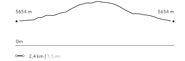
294 m 964,3 ft
-292 m -958 ft
5.984 m 19.628 ft
5.654 m 18.545 ftElevation Profile
Colorado
Montaña
-
High Mountain Ascent
-
Expert
-
Full-day
We take a van during two hours up to the base of the Colorado Volcano to begin ascending an increasingly steep slope...
More details >Colorado
-
Exploration Path
We take a van during two hours up to the base of the Colorado Volcano to begin ascending an increasingly steep slope. We’ll walk among loose rocks up to the summit. We’ll hike down a scree slope.
934 m 3064 ft
-983 m -3224 ft
5.780 m 18.958 ft
4.800 m 15.744 ftElevation Profile
Licancabur
Montaña
-
Expedition
-
Expert
-
Full-day
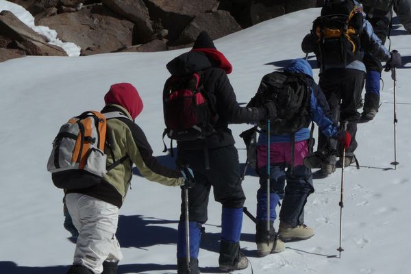
After having conducted several explorations at more than 4,000 m.a.s.l. and gradually acclimatizing our body, we leave by van...
More details >Licancabur

-
Exploration Path
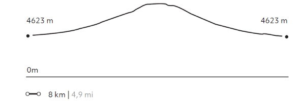
After having conducted several explorations at more than 4,000 m.a.s.l. (13,123 f.a.s.l) and gradually acclimatizing our body, we leave by van from explora to a remote camp in Bolivia on the sixth day. Once settled in the camp, we take a walk across the areas of the Verde and Blanca lagoons, from where we have a good view of the Licancabur Volcano. The next day we wake up early to begin walking before dawn. We use headlamps to light a well-marked trail. Halfway along the ascent we watch the dawn over the Blanca and Verde lagoons. We reach the summit after walking for several hours. From here, we have a view to the crater and the world’s highest lagoon. Descent can be challenging due to steep slopes and unstable terrain. We cross oldInca ruins on the way back.
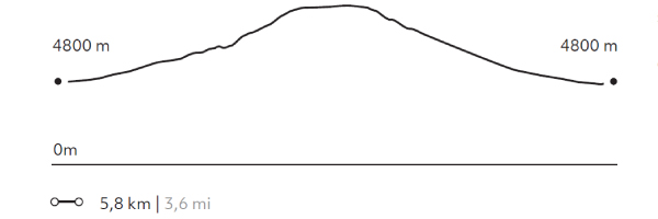
1298 m 4257 ft
-1295 m -4248 ft
5.916 m 19.404 ft
4.623 m 15.163 ftElevation Profile
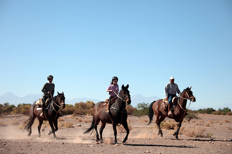
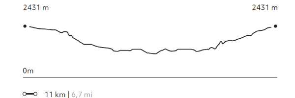
Séquitor
Cuenca del salar
-
Horseback Ride
-
Easy
-
Half-day
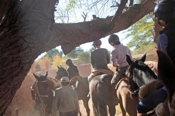
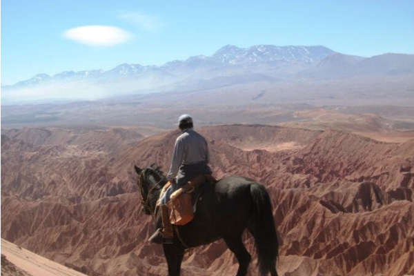
We horseback ride to the ayllus located in Séquitor, Yaye, and Checar, Atacameño social and farming communities that are also...
More details >Séquitor


-
Exploration Path
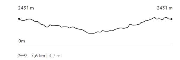
We horseback ride to the ayllus located in Séquitor, Yaye, and Checar, Atacameño social and farming communities that are also considered small oasis in the middle of the desert. Here, vegetable gardens still prevail and the Atacama construction technique using adobe and straw roofs is still seen.
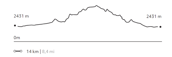
42 m 137,4 ft
-42 m -137 ft
2.431 m 7.974 ft
2.410 m 7.905 ftElevation Profile
Solor
Cuenca del salar
-
Horseback Ride
-
Easy
-
Half-day
We travel to the ayllu in Solor, located to the south of San Pedro. Here we can see one of the oasis’s most developed farming areas...
More details >Solor
-
Exploration Path
We travel to the ayllu in Solor, located to the south of San Pedro. Here we can see one of the oasis’s most developed farming areas. On our way, we can see typical desert constructions –using adobe and straw roofs– and we go across a small irrigation canal. Before we return, we visit the mythical Librería del desierto.
64 m 211 ft
-64 m -211 ft
2.431 m 7.974 ft
2.400 m 7.872 ftElevation Profile
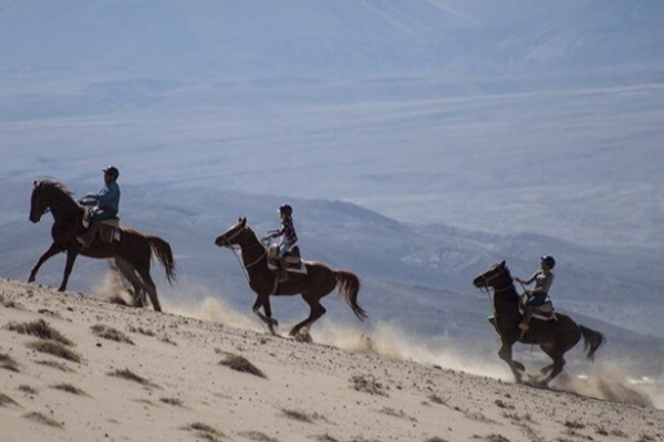
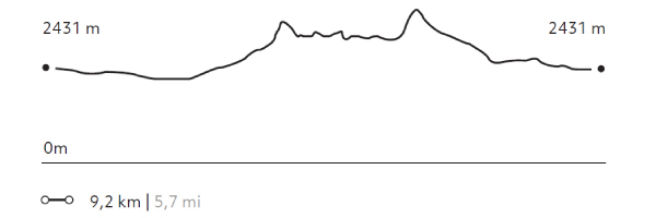
Dunas de la Chula
Cuenca del salar
-
Horseback Ride
-
Easy
-
Half-day
We horseback ride to the Salt Mountain Range. We go across the San Pedro River and sand dunes, from where we have panoramic views...
More details >Dunas de la Chula
-
Exploration Path
We horseback ride to the Salt Mountain Range. We go across the San Pedro River and sand dunes, from where we have panoramic views of the Andes Mountain Range and the oasis. Afterwards, we follow through a dry riverbed and comeback to Explora through the pampa.
114 m 374 ft
-114 m -374 ft
2.481 m 8.138 ft
2.410 m 7.905 ftElevation Profile
Valle de Marte
Cuenca del salar
-
Horseback Ride
-
Advanced
-
Half-day
We leave the hotel to go to the Mars Valley, where we horseback ride among typical desert landscapes: dunes...
More details >Valle de Marte

-
Exploration Path
We leave the hotel to go to the Mars Valley, where we horseback ride among typical desert landscapes: dunes, reddish sedimentary rock formations and clay grounds. This exploration is perfect to get an idea of the geography and origin of the Salt Ridge.
For experienced and advanced riders only. This exploration is only available for advanced riders who have mastered rising trot and canter over uneven terrain in open spaces and on all types of horses. A test in the hotel is required before going out into the desert.
*Temporarily unavailable. Consult other exploration options with your Explora guide at the destination.
241 m 790 ft
-241 m -790 ft
2.556 m 8.384 ft
2.428 m 7.964 ftElevation Profile
-
Other options: