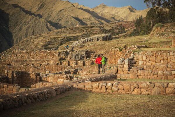
Sacred Valley
Machu Picchu & Sacred Valley, Peru
Explorations in
Sacred Valley
Activity
Difficulty
Areas
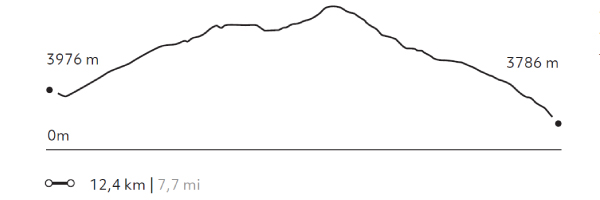
La Verónica
Puna
-
 Hike
Hike -
Moderate
-
Full-day
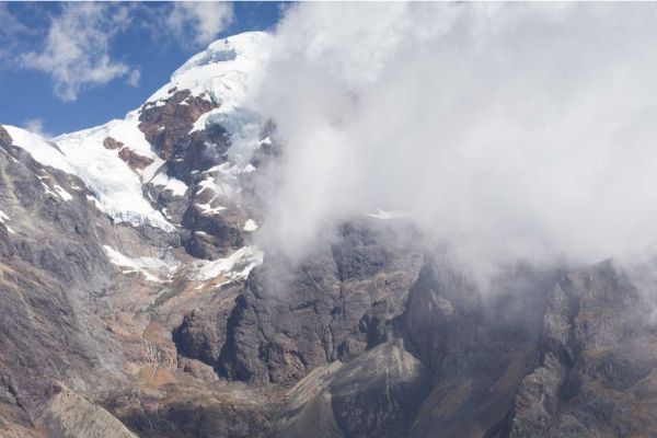
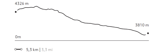
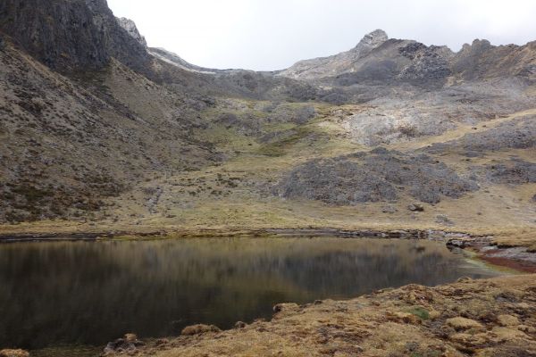
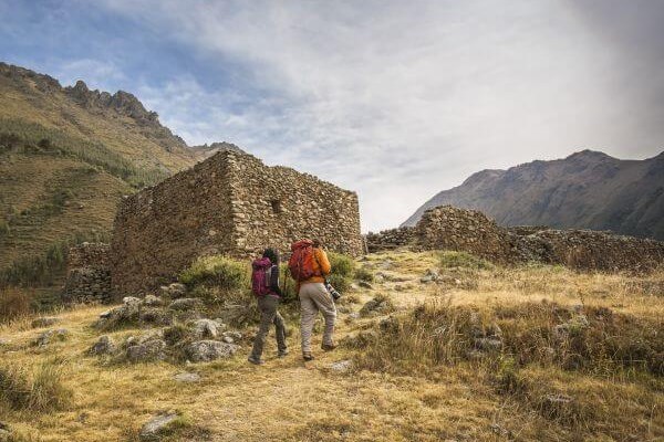
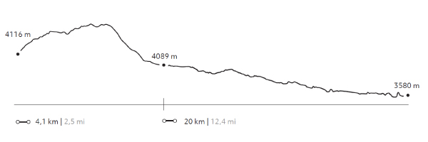
This hiking takes us through a reserve aimed at preserving forests and endangered birds. In the dry season, the snow-capped Verónica...
More details >La Verónica


-
Exploration Path
This hiking takes us through a reserve aimed at preserving forests and endangered birds. In the dry season, the snow-capped Verónica hill and the mountains surrounding it are the main attractions. During the rainy season, views may be obstructed by clouds, but then the ground steals the limelight.
164 m 538 ft
-680 m -2.231 ft
4.418 m 14.495 ft
3.810 m 12.500 ftElevation Profile
Paru
Puna
-
Hike
-
Moderate
-
Full-day
This exploration transports travelers to paths where only shepherds pass. There they will walk to more than 13000 ft. Then, following some water...
More details >Paru
-
Exploration Path
This exploration transports travelers to paths where only shepherds pass. There they will walk to more than 13000 ft. Then, following some water courses, explore the slopes of the mountains and lagoons between ranches of Paru-Paru.
726 m 2.382 ft
-588 m -1.929 ft
4.242 m 13.917 ft
3.900 m 12.795 ftElevation Profile
5 Lagunas
Puna
-
Hike
-
Moderate
-
Full-day
This walk begins at an isolated community in the heights of the Andes. From there, the trail goes up to a broad pass from...
More details >5 Lagunas
-
Exploration Path
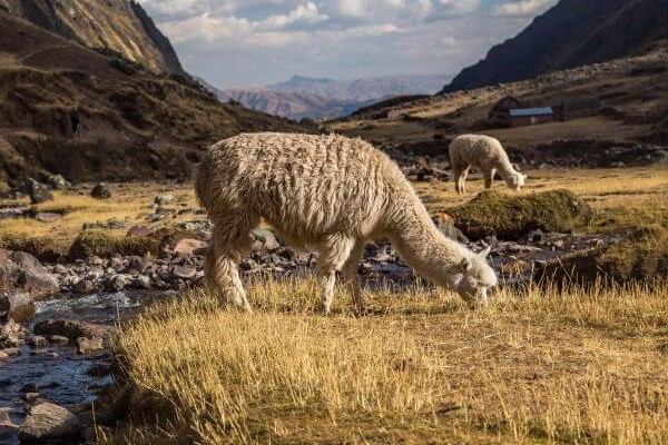
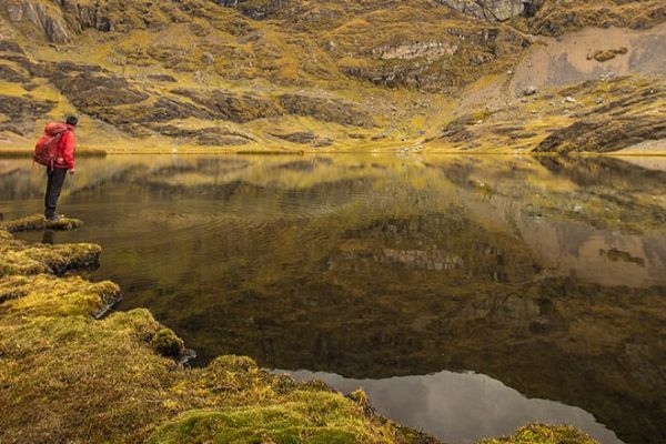
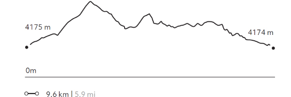
This walk begins at an isolated community in the heights of the Andes. From there, the trail goes up to a broad pass from where to observe the snow capped Sawasiray and other snowcapped peaks. The descent takes us through a ravine with llama and alpaca herds, passing beside several lagoons that reflect the large snowcapped peak in the background and the yellow-colored mountains.
432 m 1.417 ft
-435 m -1.427 ft
4.357 m 14.295 ft
4.174 m 13.694 ftElevation Profile
Lloclla
Puna
-
Hike
-
Moderate
-
Full-day
This mountain walk follows tracks used by local shepherds among lagoons serving as water deposits to sustain the area’s rural lifestyle...
More details >Lloclla
-
Exploration Path
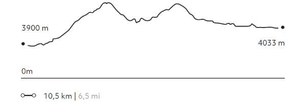
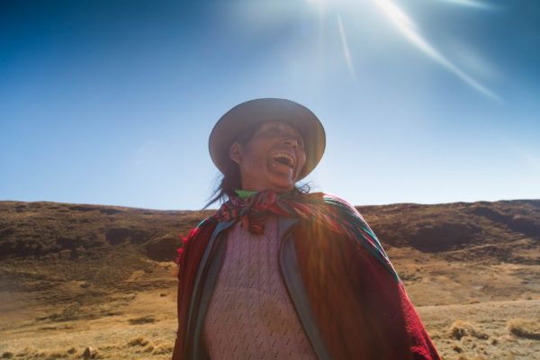
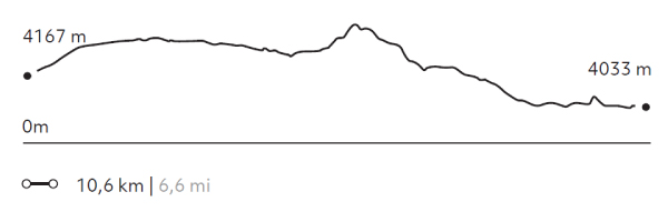
This mountain walk follows tracks used by local shepherds among lagoons serving as water deposits to sustain the area’s rural lifestyle between the valleys of Lamay and Pisac. Old mountain trails, mild slopes, views, and people, among others, invite travelers to relax, walk calmly, breathe deeply and enjoy different perspectives and colors.
432 m 1.417 ft
-583 m -1.913 ft
4.396 m 14.423 ft
4.033 m 13.232 ftElevation Profile
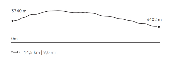
Tastayoc
Puna
-
Hike
-
Advanced
-
Full-day
We begin in the altitude, through a pastureland highly isolated from the rest of the valley. The trail includes several lagoons...
More details >Tastayoc

-
Exploration Path
We begin in the altitude, through a pastureland highly isolated from the rest of the valley. The trail includes several lagoons, some with turquoise waters due to thawing, and others with transparent waters, allowing travelers to learn about high-mountain water ecosystems.
892 m 2.927 ft
-1.085 m -3.560 ft
4.687 m 15.377 ft
3.786 m 12.421 ftElevation Profile
Stream to Cusco
Puna
-
Hike
-
Advanced
-
Full-day
The trail crosses the mountains that separate the Sacred Valley from Cusco and reaches the Town Square of the Inca’s imperial city. This road...
More details >Stream to Cusco
-
Exploration Path
The trail crosses the mountains that separate the Sacred Valley from Cusco and reaches the Town Square of the Inca’s imperial city. This road simulates the journey followed by the Incas and Spanish conquerors more than 500 years ago. Before completing the exploration, there is a guided tour to the huge walls of the Saqsaywaman and its archaeological and ceremonial centers.
630 m 2.067 ft
-968 m -3.176 ft
4.281 m 14.045 ft
3.402 m 11.161 ftElevation Profile
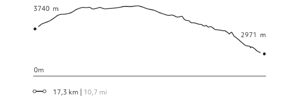
Huchuy Qosqo
Puna
-
Hike
-
Advanced
-
Full-day
This exploration offers breathtaking views to lagoons at different altitudes, to the farmlands of Chinchero and to the valleys. To reach...
More details >Huchuy Qosqo
-
Exploration Path
This exploration offers breathtaking views to lagoons at different altitudes, to the farmlands of Chinchero and to the valleys. To reach the remains of the Huchuy Qosqo Palaces, it goes down an Inca trail. Once in the remains, you cannot miss lying down in the gardens, taking a rest and enjoying the view towards Sacred Valley.
968 m 3.176 ft
-1.738 m -5.702 ft
4.318 m 14.167 ft
2.971 m 9.747 ftElevation Profile
Incañan
Puna
-
Hike
-
Expert
-
Full-day
This is the most physicallydemanding exploration and the one with the most spectacular landscapes. It crosses the Urubamba mountain...
More details >Incañan

-
Exploration Path
This is the most physicallydemanding exploration and the one with the most spectacular landscapes. It crosses the Urubamba mountain chain from north to south, over a trail that goes along the second highest peak in the region, the Sawasiray, with 19,088 ft.
1.129 m 3.704 ft
-1.497 m -4.911 ft
4.611 m 15.128 ft
3.287 m 10.784 ftElevation Profile
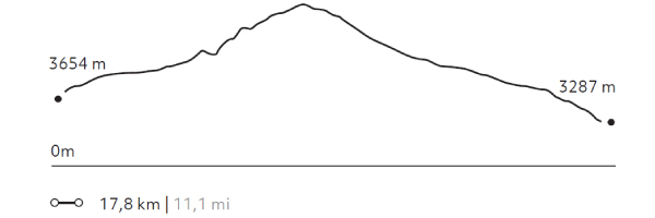
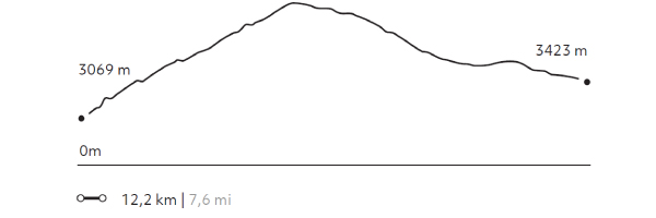
Pachatusan
Puna
-
Hike
-
Expert
-
Full-day
We begin our ascent by a path of agricultural and livestock use. During this exploration, we can see Cerro Pachatusan, considered in Inca culture...
More details >Pachatusan
-
Exploration Path
We begin our ascent by a path of agricultural and livestock use. During this exploration, we can see Cerro Pachatusan, considered in Inca culture to be the protector of the world. We walk to an open area with wide views of the Cusco Valley and finally, we descend to the archaeological centers of Pukara and Tipón, where agriculture was developed with an important Inca hydraulic system that is still in use today.
1.344 m 4.409 ft
-991 m -3.251 ft
4.179 m 13.711 ft
3.069 m 10.069 ftElevation Profile
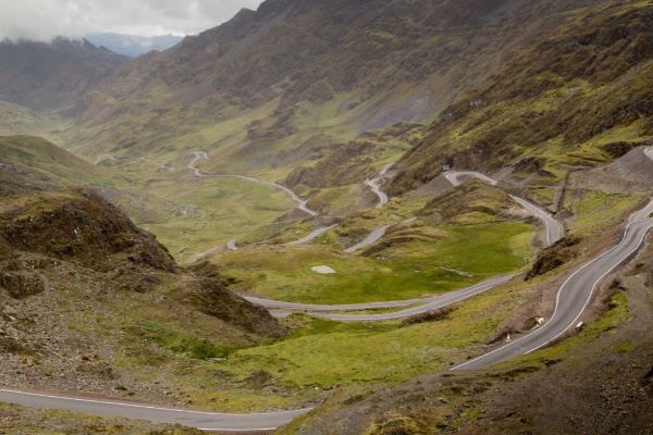
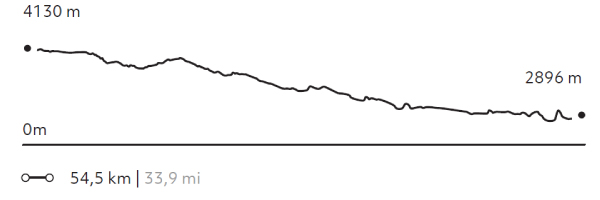
Qenqo
Puna
-
Bike
-
Expert
-
Full-day
The exploration begins in the heights of the pampas and then descends – over a vehicle road – among Quechua communities and farmlands...
More details >Qenqo

-
Exploration Path
The exploration begins in the heights of the pampas and then descends – over a vehicle road – among Quechua communities and farmlands with views to the Sacred Valley and Pisac. In the afternoon, the ride goes follows the south side of the Urubamba river among cornfields, old haciendas and manors from the 19th and 20th century.
997 m 3.271 ft
-2.209 m -7.247 ft
4.130 m 13.550 ft
2.896 m 9.501 ftElevation Profile
InkaTracks
Puna
-
Combination
-
Expert
-
Full-day
During the morning, this exploration considers a 3,3 mi walk over a mountain trail with 360º views to Cusco and the Sacred Valley.
More details >InkaTracks

-
Exploration Path
During the morning, this exploration considers a 3,3 mi walk over a mountain trail with 360º views to Cusco and the Sacred Valley. The descent is through potato plantations and pampas where shepherds tend their animals. In the afternoon, biking starts on the heights of the pampas, then going down through Quechua communities and farmlands, with views to the Sacred Valley.
1.208 m 3.963 ft
-2.484 m -8.150 ft
4.263 m 13.986 ft
3.738 m 12.264 ftElevation Profile
Valle de la Papa
Puna
-
Overland
-
Easy
-
Full-day
This exploration takes the traveler to one of the most fertile areas in the Sacred Valley. The journey begins towards the Quinsacocha lagoon...
More details >Valle de la Papa


-
Exploration Path
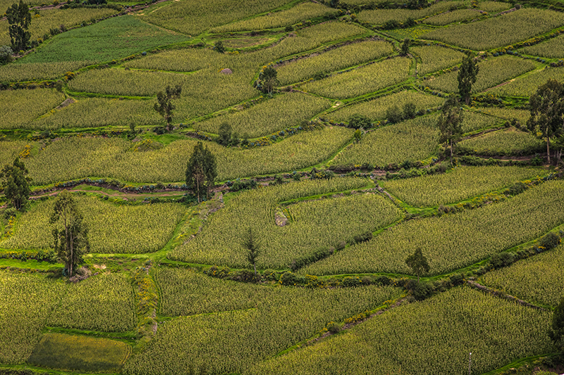
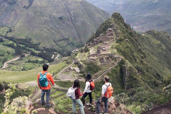
This exploration takes the traveler to one of the most fertile areas in the Sacred Valley. The journey begins towards the Quinsacocha lagoon, a sublime site that features the typical Cusco puna landscape. Going downhill, we will cross the el Valle de la Papa and next, visit the Quechua community of Chahuaytire, a place with an ancient textile tradition where we will learn about natural dying and back strap loom techniques. The trip ends with a visit to the stunning archaeological center of Pisaq, a city built on a mountain with hundreds of remarkable hanging farm terraces on its slopes.
-
Other options: