Atacama
Desert & Altiplano, Chile
Explorations in
Atacama
Activity
Difficulty
Areas
Kimal
Montaña
-
 High Mountain Ascent
 -
Moderate
-
Full-day
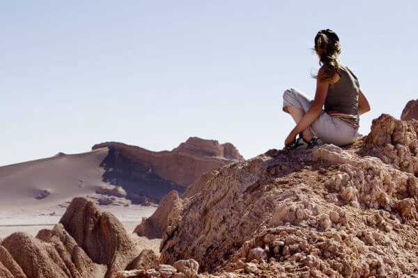
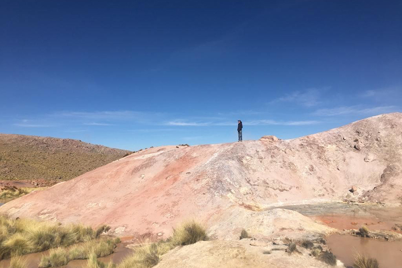
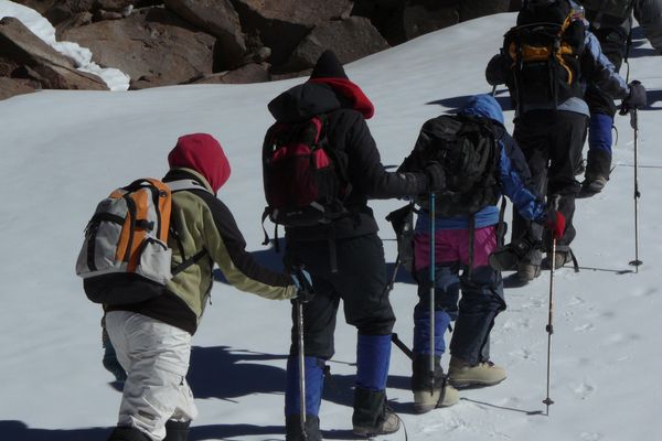
We ride a van for two hours to the Domeyko Mountain Range, until we reach the Kimal hill, the source of one of the most iconic Atacameño...
More details >Kimal


-
Exploration Path
We ride a van for two hours to the Domeyko Mountain Range, until we reach the Kimal hill, the source of one of the most iconic Atacameño legends. We walk up a steep trail to the summit with panoramic views to the salt field and the mythical Licancabur and Juriques volcanoes. We descend and return to the hotel.
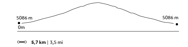
695 m 2280 ft
-752 m -2467 ft
4.266 m 13.992 ft
3.594 m 11.788 ftElevation Profile
Toco
Montaña
-
High Mountain Ascent
-
Moderate
-
Half-day
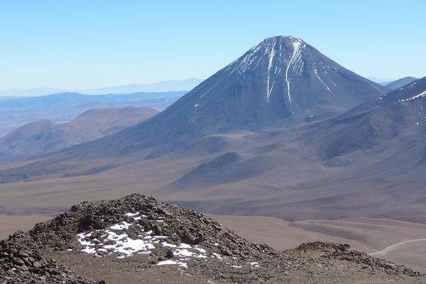
We leave by van and head to the Andes Mountains, an hour from Explora, where we begin ascending...
More details >Toco
-
Exploration Path
We leave by van and head to the Andes Mountains, an hour from Explora, where we begin ascending. We take a steep trail up to the summit with views to Bolivia, Argentina, and the surrounding volcanoes.
*Ideal introduction to high mountain.
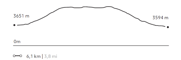
520 m 1706 ft
-520 m -1706 ft
5.610 m 18.401 ft
5086 m 16682 ftElevation Profile
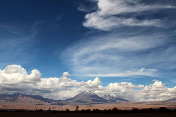
Láscar
Montaña
-
High Mountain Ascent
-
Moderate
-
Full-day
We take a van for two hours entering the altiplano of the Andes Mountain Range. At the base of the active Láscar volcano we begin our ascent...
More details >Láscar
-
Exploration Path
We take a van for two hours entering the altiplano of the Andes Mountain Range. At the base of the active Láscar volcano we begin our ascent through a soft terrain and gradually climb. At the summit we will have a wide view with different volcanoes and the Salar de Atacama basin.
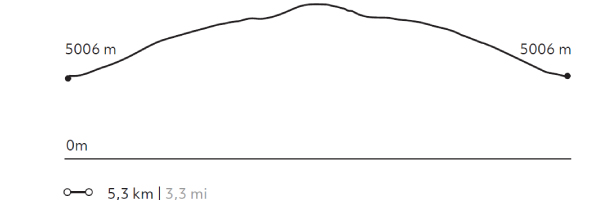
594 m 1948 ft
-594 m -1948 ft
5.592 m 18.342 ft
5.006 m 16.420 ftElevation Profile
Corona
Montaña
-
High Mountain Ascent
-
Advanced
-
Full-day
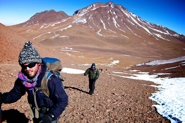
We take a van for two hours up to the base of the Corona Hill. There, we begin ascending through a challenging terrain due to the presence of...
More details >Corona

-
Exploration Path
We take a van for two hours up to the base of the Corona Hill. There, we begin ascending through a challenging terrain due to the presence of crags and loose sand that make movement difficult. At the summit, we see different volcanoes, among them the Lascar with its typical vent.
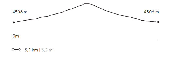
769 m 2522 ft
-769 m -2522 ft
5.262 m 17.259 ft
4.506 m 14.780 ftElevation Profile
Soquete
Montaña
-
High Mountain Ascent
-
Advanced
-
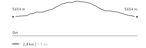
Full-day
We start walking through mud geysers, crossing green valleys with high Andean flora and fauna. After passing through different geological...
More details >Soquete
-
Exploration Path
We start walking through mud geysers, crossing green valleys with high Andean flora and fauna. After passing through different geological formations we reach the needle, its particular summit formed by eruptions and carved by the erosion of wind and water.
883 m 2896 ft
-883 m -2896 ft
5.366 m 17.600 ft
4.487 m 14.717 ftElevation Profile
Sairecabur
Montaña
-
High Mountain Ascent
-
Expert
-
Full-day
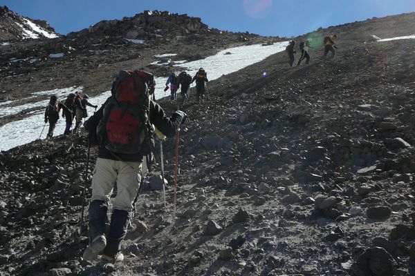
After a one-and-a-half hour drive by van, we reach the Sairecabur Volcano’s caldera, where we begin ascending. We walk through rocks...
More details >Sairecabur

-
Exploration Path
After a one-and-a-half hour drive by van, we reach the Sairecabur Volcano’s caldera, where we begin ascending. We walk through rocks, stones and loose crags and cross a former sulfur mine before taking the final steep hike.
We will reach the highest point of our explorations at the summit of the "mountain of rain", the meaning of its name.
294 m 964,3 ft
-292 m -958 ft
5.984 m 19.628 ft
5.654 m 18.545 ftElevation Profile
Colorado
Montaña
-
High Mountain Ascent
-
Expert
-
Full-day
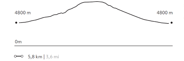
We take a van during two hours up to the base of the Colorado Volcano to begin ascending an increasingly steep slope...
More details >Colorado
-
Exploration Path
We take a van during two hours up to the base of the Colorado Volcano to begin ascending an increasingly steep slope. We’ll walk among loose rocks up to the summit. We’ll hike down a scree slope.
934 m 3064 ft
-983 m -3224 ft
5.780 m 18.958 ft
4.800 m 15.744 ftElevation Profile
-
Other options: